Graham · Glen Coe & Lochaber
Beinn Mheadhonach
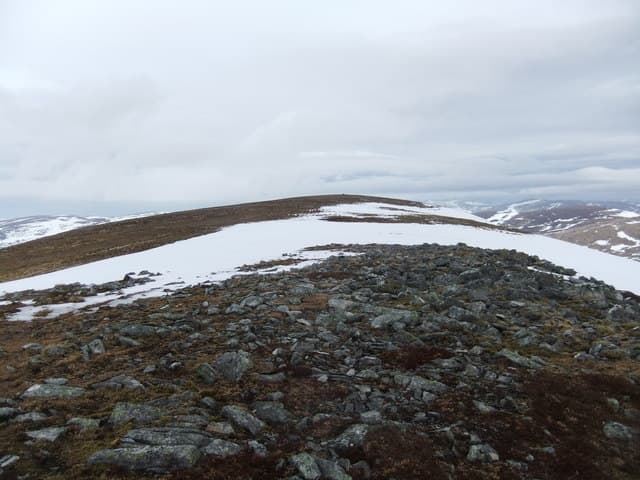
Beinn Mheadhonach (715m) — the middle hill — sits at NN01 north of Loch Etive between the Glen Kinglass corridor and the Bridge of Orchy hills. Its modest 252m re-ascent reflects a position wedged between higher Munros, but the cairn-marked summit offers a fine sightline along Loch Etive's long sea finger and across to the Cruachan horseshoe. The name (mheadhonach = middle) recurs across Scotland; this one is the Argyll example.
Quick facts
- Height
- 715m/ 2346ft
- Prominence
- 252 m
- Distance
- 13 km
- Ascent
- 586 m
- Time
- 3–6 hrs
- Grid ref
- NN019368
- Parking
- NN023376
- Nearest city
- Oban· 17km
- Dogs
- Dogs on lead required near livestockDog-friendly guide ↗
Height and prominence cross-checked against the Database of British and Irish Hills (CC BY).
No GPX track yet
Walked this route? Share your track to help other walkers.
Standard route
glen track 25% · deep heather 45% · grassy upper slopes 20% · summit area 10%
Approach from the Inverliever forestry road off the Loch Awe-side B845, gaining the western shoulder via a long but pleasant track-and-rough-grass ascent. Alternatively a longer day from Glen Kinglass via the bothy approach. 13km, 586m of climbing for the standard western round, with most of the elevation in the upper third.
Terrain
The Inverliever forestry road thins to a quad track and finally a stalkers' path. Above 500m the hill is broad rough grass with peat hags and occasional rock ribs; nothing technical. The summit is a low rocky outcrop on a shoulder, easily missed in cloud — note the GPS waypoint.
In winter
Snow accumulates on the broad east-facing shoulder, with localised windslab in deep northerlies; the Lochaber SAIS region is the appropriate reference for nearby corries. Loch Etive's humid air promotes rime build-up on fence posts and rocks even in marginal frost. Daylight is short but the southern aspect on the standard route catches what sun there is.
This hill is in the Glen Coe SAIS forecast area. Check SAIS forecasts in winter (December–April).
Best time of year
Getting there
- Glasgow2h 57m
- Edinburgh3h 57m
OS maps: OS Landranger 50
Mobile signal: Mostly absent on the approach; weak signal returns toward the Etive end of the summit
Current conditions
Daylight Today
- Sunrise
- 04:55
- Sunset
- 21:59
- Civil dawn
- 03:58
- Civil dusk
- 22:56
NOAA Solar Calculator · 17 July 2026
Around Beinn Mheadhonach on the SCOT network
Getting there, basing yourself, and what to do off the hill.
Getting there: Loch Awe station
East shore Loch Awe; Ben Cruachan; Kilchurn Castle
14km from the hill
tripscot.co.uk
On TripSCOTBase yourself in Oban
Argyll ferry hub — Mull, Lismore, Coll, Tiree, Barra
18km from the hill
tripscot.co.uk
On TasteSCOTAfter the hill: Oban
Oban town centre — tiny two-still distillery bridging Highland and West Coast styles
18km from the hill
tastescot.co.uk
Beinn Mheadhonach — common questions
- Is Beinn Mheadhonach a hard climb?
- Beinn Mheadhonach is rated 3/5 (moderately challenging) on the OutdoorSCOT scale. The standard route covers about 13km with 586m of ascent and takes most walkers 3-6 hours. Underfoot: The Inverliever forestry road thins to a quad track and finally a stalkers' path.
- What is Beinn Mheadhonach's prominence?
- 252m of prominence. That's the vertical drop from the summit to the col that links Beinn Mheadhonach to the next higher ground.
- Where do I park for Beinn Mheadhonach?
- Most walkers start from NN023376. Verify the grid reference on an OS map before you set off — space is tight on busy summer weekends.
- When is the best time to climb Beinn Mheadhonach?
- April, May, June, July, August, September, October give the most reliable conditions on Beinn Mheadhonach. Beyond that window the high ground turns wintry: carry full mountain kit, be confident navigating, and check the SAIS avalanche forecast for the area.
- Is Beinn Mheadhonach dog-friendly?
- Yes, but dogs must be kept on a lead — there is livestock or ground-nesting bird interest on the route.
- Is there mobile signal on Beinn Mheadhonach?
- Mostly absent on the approach; weak signal returns toward the Etive end of the summit
- Is Beinn Mheadhonach safe in winter?
- Snow accumulates on the broad east-facing shoulder, with localised windslab in deep northerlies; the Lochaber SAIS region is the appropriate reference for nearby corries. Loch Etive's humid air promotes rime build-up on fence posts and rocks even in marginal frost. Daylight is short but the southern aspect on the standard route catches what sun there is.
Get the OutdoorSCOT weekly
One email a week — new route, hill and bothy guides, seasonal conditions and the odd hard-won lesson. No spam, unsubscribe in one click.