Graham · Glen Coe & Lochaber
Mam Hael (Beinn Bhreac)
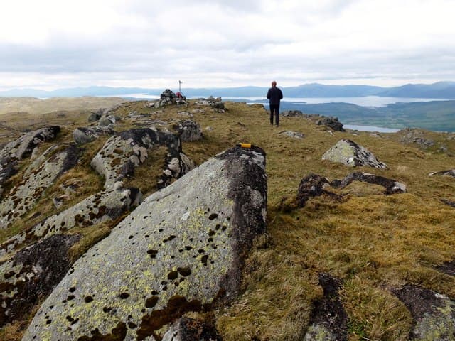
A heathery Graham on the north side of Glen Creran in Appin, looking south-west to Loch Creran and the Lismore islands. A quiet hill in a quiet glen — perfect for a short Argyll day.
Quick facts
- Height
- 723.8m/ 2375ft
- Prominence
- 159 m
- Distance
- 13 km
- Ascent
- 593 m
- Time
- 3–6 hrs
- Grid ref
- NN008408
- Parking
- NN018414
- Nearest city
- Oban· 18km
- Dogs
- Dogs on lead required near livestockDog-friendly guide ↗
Height and prominence cross-checked against the Database of British and Irish Hills (CC BY).
No GPX track yet
Walked this route? Share your track to help other walkers.
Standard route
glen path 20% · heather hillside 50% · grassy upper slopes 20% · summit area 10%
Park at the Glasdrum National Nature Reserve car park at the foot of Glen Creran. Follow the reserve path north into the oak woods, then break east on faint deer tracks up the south-west ridge to the broad summit.
Terrain
Atlantic oak woodland on the lower slopes — pleasant walking on root-laced paths. Higher up, deep heather and small crags. The summit is grassy and rounded.
In winter
Low-altitude Argyll Graham — snow rarely lies long but the oak woods become genuinely greasy after rain. Watch for fallen branches after winter storms.
This hill is in the Glen Coe SAIS forecast area. Check SAIS forecasts in winter (December–April).
Best time of year
Getting there
- Glasgow2h 2m
- Edinburgh3h 1m
OS maps: OS Landranger 50
Mobile signal: Patchy in Glen Creran; better near the Loch Creran shore
Current conditions
Daylight Today
- Sunrise
- 04:49
- Sunset
- 22:04
- Civil dawn
- 03:50
- Civil dusk
- 23:03
NOAA Solar Calculator · 13 July 2026
Around Mam Hael (Beinn Bhreac) on the SCOT network
Getting there, basing yourself, and what to do off the hill.
Getting there: Loch Awe station
East shore Loch Awe; Ben Cruachan; Kilchurn Castle
18km from the hill
tripscot.co.uk
On TripSCOTBase yourself in Oban
Argyll ferry hub — Mull, Lismore, Coll, Tiree, Barra
19km from the hill
tripscot.co.uk
On TasteSCOTAfter the hill: Oban
Oban town centre — tiny two-still distillery bridging Highland and West Coast styles
18km from the hill
tastescot.co.uk
Mam Hael (Beinn Bhreac) — common questions
- How hard is Mam Hael (Beinn Bhreac)?
- We grade Mam Hael (Beinn Bhreac) at 3/5, which puts it in moderately challenging territory. The usual route is around 13km with 593m of climbing; allow 3-6 hours. Underfoot: Atlantic oak woodland on the lower slopes — pleasant walking on root-laced paths.
- What is Mam Hael (Beinn Bhreac)'s prominence?
- 159m of prominence. That's the vertical drop from the summit to the col that links Mam Hael (Beinn Bhreac) to the next higher ground.
- Where do I park for Mam Hael (Beinn Bhreac)?
- Most walkers start from NN018414. Verify the grid reference on an OS map before you set off — space is tight on busy summer weekends.
- When is the best time to climb Mam Hael (Beinn Bhreac)?
- April, May, June, July, August, September, October give the most reliable conditions on Mam Hael (Beinn Bhreac). Beyond that window the high ground turns wintry: carry full mountain kit, be confident navigating, and check the SAIS avalanche forecast for the area.
- Is Mam Hael (Beinn Bhreac) dog-friendly?
- Yes, but dogs must be kept on a lead — there is livestock or ground-nesting bird interest on the route.
- Is there mobile signal on Mam Hael (Beinn Bhreac)?
- Patchy in Glen Creran; better near the Loch Creran shore
- Is Mam Hael (Beinn Bhreac) safe in winter?
- Low-altitude Argyll Graham — snow rarely lies long but the oak woods become genuinely greasy after rain. Watch for fallen branches after winter storms.
Get the OutdoorSCOT weekly
One email a week — new route, hill and bothy guides, seasonal conditions and the odd hard-won lesson. No spam, unsubscribe in one click.