Munro · Glen Coe & Lochaber
Ben Cruachan
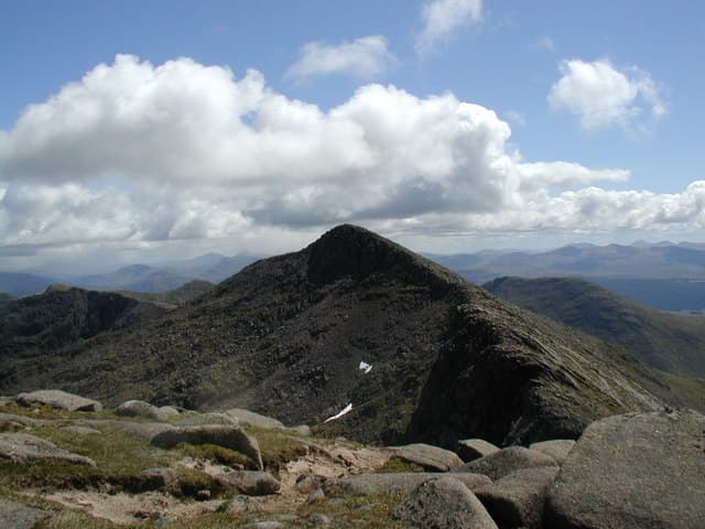
Ben Cruachan is the highest peak in Argyll at 1126m, the most dominant skyline feature on the west coast between Oban and Glen Coe. The mountain is a twin-peaked massif of seven tops — the "Cruachan Horseshoe" being one of the great ridge rounds in Scotland — with a hydroelectric reservoir on its eastern flank and the famous Ben Cruachan power station carved into the mountain itself. The summit is a small rocky knob beside a trig point, looking down 1100m to Loch Awe and out west across the firth to Mull.
Quick facts
- Height
- 1127m/ 3698ft
- Prominence
- 880 m
- Distance
- 18 km
- Ascent
- 992 m
- Time
- 6–9 hrs
- Grid ref
- NN069304
- Parking
- NN078267
- Nearest city
- Oban· 21km
- Dogs
- Dogs on lead required near livestockDog-friendly guide ↗
Height and prominence cross-checked against the Database of British and Irish Hills (CC BY).
No GPX track yet
Walked this route? Share your track to help other walkers.
Standard route
Glen / waterfall path 30% · Open hillside 35% · Rocky summit ridge 35%
The classic line is the Cruachan Horseshoe from the Falls of Cruachan halt on the A85. Climb steeply north through the falls to the Cruachan reservoir, then ascend the south ridge of Meall Cuanail and traverse the ridge over Cruachan and Stob Daimh — around 18km with 1500m of ascent for the full round. A shorter route does only Ben Cruachan via the south ridge from the reservoir; 13km return with 1000m up.
Terrain
The Falls of Cruachan path is steep through forestry to the reservoir then opens onto rough ground. The summit ridge is narrow with rocky steps; the connecting traverse to Stob Daimh involves a brief Grade 1 scramble in a couple of places. The summit cairn / trig perches on a small rocky knob with significant exposure on the north side above Coire Cruachan.
In winter
A major Argyll winter mountain. The Cruachan north faces hold Grade III-V winter climbs. Cornices form along the summit ridge and the connection to Stob Daimh. The reservoir access road is gritted for power station vehicles; the path up from the railway can ice over. SAIS Glen Coe is the closest regional report.
This hill is in the Glen Coe SAIS forecast area. Check SAIS forecasts in winter (December–April).
Best time of year
Getting there
- Glasgow2h 46m
- Edinburgh3h 48m
OS maps: OS Landranger 50
Mobile signal: Good signal at the Cruachan Power Station visitor centre and the A85 car park. Signal drops above 700m. The distinctive twin peaks of Cruachan are visible from much of Argyll.
Current conditions
Daylight Today
- Sunrise
- 05:05
- Sunset
- 21:49
- Civil dawn
- 04:12
- Civil dusk
- 22:42
NOAA Solar Calculator · 23 July 2026
Pair with
Curated multi-hill combinations from Ben Cruachan.
Around Ben Cruachan on the SCOT network
Getting there, basing yourself, and what to do off the hill.
Getting there: Loch Awe station
East shore Loch Awe; Ben Cruachan; Kilchurn Castle
6km from the hill
tripscot.co.uk
On TripSCOTBase yourself in Oban
Argyll ferry hub — Mull, Lismore, Coll, Tiree, Barra
21km from the hill
tripscot.co.uk
On TasteSCOTAfter the hill: Oban
Oban town centre — tiny two-still distillery bridging Highland and West Coast styles
21km from the hill
tastescot.co.uk
Ben Cruachan — common questions
- How hard is Ben Cruachan?
- We grade Ben Cruachan at 4/5, which puts it in challenging territory. The usual route is around 18km with 992m of climbing; allow 6-9 hours. Underfoot: The Falls of Cruachan path is steep through forestry to the reservoir then opens onto rough ground.
- What is Ben Cruachan's prominence?
- 880m of prominence. That's the vertical drop from the summit to the col that links Ben Cruachan to the next higher ground.
- Where do I park for Ben Cruachan?
- Most walkers start from NN078267. Verify the grid reference on an OS map before you set off — space is tight on busy summer weekends.
- When is the best time to climb Ben Cruachan?
- May, June, July, August, September, October give the most reliable conditions on Ben Cruachan. Beyond that window the high ground turns wintry: carry full mountain kit, be confident navigating, and check the SAIS avalanche forecast for the area.
- Is Ben Cruachan dog-friendly?
- Yes, but dogs must be kept on a lead — there is livestock or ground-nesting bird interest on the route.
- Is there mobile signal on Ben Cruachan?
- Good signal at the Cruachan Power Station visitor centre and the A85 car park. Signal drops above 700m. The distinctive twin peaks of Cruachan are visible from much of Argyll.
- Is Ben Cruachan safe in winter?
- A major Argyll winter mountain. The Cruachan north faces hold Grade III-V winter climbs. Cornices form along the summit ridge and the connection to Stob Daimh. The reservoir access road is gritted for power station vehicles; the path up from the railway can ice over. SAIS Glen Coe is the closest regional report.
Get the OutdoorSCOT weekly
One email a week — new route, hill and bothy guides, seasonal conditions and the odd hard-won lesson. No spam, unsubscribe in one click.