Corbett · Loch Awe
Beinn a' Bhuiridh
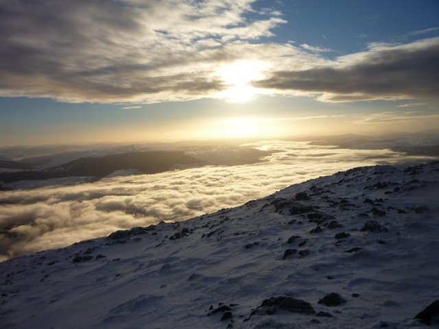
Beinn a' Bhuiridh — "the hill of the bellowing", referring to rutting stags — is the southern outlier of the Ben Cruachan massif, standing high above the Pass of Brander and the upper reaches of Loch Awe. At 898m it falls just short of Munro height and sits in the long shadow of the Cruachan Munros to the north, but its position above the loch gives one of the most photographed mountain skylines in Argyll. The summit is a small rocky platform with a steep drop south into Coire Ghlas.
Gaelic: “mountain, of the, roaring” · Pronunciation: bine uh bhuiridh
Quick facts
- Height
- 898.4m/ 2948ft
- Prominence
- 172 m
- Distance
- 16 km
- Ascent
- 790 m
- Time
- 5–8 hrs
- Grid ref
- NN094283
- Parking
- NN078267
- Nearest city
- Oban· 24km
- Dogs
- Dogs on lead required near livestockDog-friendly guide ↗
Height and prominence cross-checked against the Database of British and Irish Hills (CC BY).
No GPX track yet
Walked this route? Share your track to help other walkers.
Standard route
private road 20% · steep grass 40% · rocky ridge 30% · summit plateau 10%
Start from the Cruachan Power Station visitor centre lay-by on the A85 and take the steep zig-zag path up beside the railway to the Cruachan Reservoir dam. From the dam, follow the south shore briefly then turn south-east up open grass and rock onto the south ridge of Beinn a' Bhuiridh. The ridge climbs gradually with rocky steps to the summit. Around 16km return with 790m of ascent if combined with the Cruachan reservoir circuit; a direct out-and-back is shorter.
Terrain
The initial path beside the railway is steep and slippery on wet pine needles. The reservoir tarmac is straightforward but the climb out of the dam onto the ridge is on steep grass with rocky steps — slow going. The summit ridge has a few short scrambling moves over weathered schist blocks, easy in dry weather but treacherous when wet. The drop into Coire Ghlas is sudden; keep clear of the south edge.
In winter
A hill that catches the full west coast precipitation cycle — snow rarely persists for long but a freeze-thaw cycle can leave the south ridge glazed with verglas. Cornices form on the south face above Coire Ghlas. The reservoir access road is gritted by Scottish Power but the steep path from the A85 is icy when wet. Connecting traverses to the Cruachan Munros require full winter kit.
This hill is in the Glen Coe SAIS forecast area. Check SAIS forecasts in winter (December–April).
Best time of year
Getting there
- Glasgow2h 42m
- Edinburgh3h 44m
OS maps: OS Landranger 50
Mobile signal: No signal in the Loch Awe area hills; very brief coverage possible on the summit
Current conditions
Daylight Today
- Sunrise
- 04:49
- Sunset
- 22:03
- Civil dawn
- 03:51
- Civil dusk
- 23:01
NOAA Solar Calculator · 13 July 2026
Pair with
Curated multi-hill combinations from Beinn a' Bhuiridh.
Around Beinn a' Bhuiridh on the SCOT network
Getting there, basing yourself, and what to do off the hill.
Getting there: Loch Awe station
East shore Loch Awe; Ben Cruachan; Kilchurn Castle
3km from the hill
tripscot.co.uk
On TripSCOTBase yourself in Oban
Argyll ferry hub — Mull, Lismore, Coll, Tiree, Barra
24km from the hill
tripscot.co.uk
On TasteSCOTAfter the hill: Oban
Oban town centre — tiny two-still distillery bridging Highland and West Coast styles
24km from the hill
tastescot.co.uk
Beinn a' Bhuiridh — common questions
- How difficult is Beinn a' Bhuiridh?
- Beinn a' Bhuiridh carries a 4/5 (challenging) grade on the OutdoorSCOT scale. Count on about 16km, 790m of ascent and a 5-8 hour day on the standard route. Terrain: The initial path beside the railway is steep and slippery on wet pine needles.
- How prominent is Beinn a' Bhuiridh?
- Beinn a' Bhuiridh has 172m of topographic prominence — the height of its summit above the highest col connecting it to higher ground.
- Where should I park to climb Beinn a' Bhuiridh?
- Standard parking is at NN078267. Check the parking grid reference on an OS map before travel; informal laybys can fill on summer weekends.
- When should I climb Beinn a' Bhuiridh?
- The standard good-weather months for Beinn a' Bhuiridh are May, June, July, August, September, October. Outside those months, expect winter conditions on the high ground — full mountain kit, navigation skills, and a check of the SAIS avalanche forecast for the relevant region.
- Can I bring my dog up Beinn a' Bhuiridh?
- On a lead only — the route crosses ground with livestock or nesting-bird interest.
- What's mobile reception like on Beinn a' Bhuiridh?
- No signal in the Loch Awe area hills; very brief coverage possible on the summit
- Is Beinn a' Bhuiridh safe in winter?
- A hill that catches the full west coast precipitation cycle — snow rarely persists for long but a freeze-thaw cycle can leave the south ridge glazed with verglas. Cornices form on the south face above Coire Ghlas. The reservoir access road is gritted by Scottish Power but the steep path from the A85 is icy when wet. Connecting traverses to the Cruachan Munros require full winter kit.
Get the OutdoorSCOT weekly
One email a week — new route, hill and bothy guides, seasonal conditions and the odd hard-won lesson. No spam, unsubscribe in one click.