Corbett · Glen Etive
Glas Bheinn
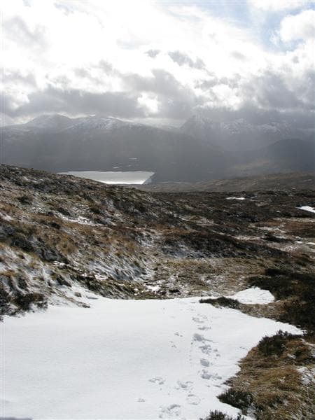
This Glas Bheinn — "green hill", a common Highland name — is the 789m Corbett on the eastern fringe of the Black Mount, in the rough country between Glen Etive and Loch Tulla. The hill is overshadowed by its Munro neighbours in the Black Mount but offers a quieter alternative with one of the most striking views of the Stob Ghabhar massif. The summit is a small cairn on a grassy dome with steep crag-broken flanks dropping into Glen Etive on its west side.
Gaelic: “grey-green” · Pronunciation: glass bheinn
Quick facts
- Height
- 789.8m/ 2591ft
- Prominence
- 387 m
- Distance
- 14 km
- Ascent
- 647 m
- Time
- 4–7 hrs
- Grid ref
- NN258641
- Parking
- NN271423
- Nearest city
- Fort William· 18km
- Dogs
- Dogs on lead required near livestockDog-friendly guide ↗
Height and prominence cross-checked against the Database of British and Irish Hills (CC BY).
No GPX track yet
Walked this route? Share your track to help other walkers.
Standard route
estate road 30% · rough heather 30% · grassy ridge 30% · summit dome 10%
The most direct approach starts from Forest Lodge at the head of Loch Tulla on the A82 and follows the estate road west toward Clashgour. About 3km along the road, step off and climb pathless heather and grass to gain the broad south ridge of Glas Bheinn. A steady plod up the ridge reaches the cairn. About 14km return with 647m of climbing. Sometimes combined with Beinn Mhic Mhonaidh or extended toward Stob Ghabhar for a major day.
Terrain
The Clashgour estate road is firm gravel. Above the track the lower hill is rough heather and peat; the upper ridge is short grass with intermittent crag bands. The summit dome is broad mossy grass. The west face is steep and crag-broken — keep east of the summit cairn on descent. No exposure on the standard line.
In winter
A reasonably serious winter hill — the west face becomes a serious snow slope after westerly storms, and the summit ridge can hold cornices on the west edge. The A82 corridor is gritted but the lay-by ices. Forest Lodge accessibility is reliable in any conditions. Best done as a clear-weather day.
This hill is in the Glen Coe SAIS forecast area. Check SAIS forecasts in winter (December–April).
Best time of year
Getting there
- Glasgow2h 13m
- Edinburgh3h 51m
OS maps: OS Landranger 41, OS Explorer 384
Mobile signal: Reasonable signal at Forest Lodge / A82; nothing on the upper hill
Current conditions
Daylight Today
- Sunrise
- 04:46
- Sunset
- 22:04
- Civil dawn
- 03:46
- Civil dusk
- 23:04
NOAA Solar Calculator · 13 July 2026
Around Glas Bheinn on the SCOT network
Getting there, basing yourself, and what to do off the hill.
Getting there: Corrour station
Highest mainline station; Loch Ossian, Ben Alder, Aonach Beag (Alder)
10km from the hill
tripscot.co.uk
On TripSCOTBase yourself in Fort William
Ben Nevis base, West Highland Line, gateway to Lochaber
18km from the hill
tripscot.co.uk
On TasteSCOTAfter the hill: Ben Nevis Distillery
Fort William — Lochaber distillery at the foot of the Ben; long-aged Japanese-owned classics
18km from the hill
tastescot.co.uk
Glas Bheinn — common questions
- How difficult is Glas Bheinn?
- Glas Bheinn carries a 2/5 (moderate) grade on the OutdoorSCOT scale. Count on about 14km, 647m of ascent and a 4-7 hour day on the standard route. Ground conditions: The Clashgour estate road is firm gravel.
- How much drop does Glas Bheinn have?
- The drop is 387m: measured from the summit of Glas Bheinn down to the saddle joining it to higher terrain.
- Where's the parking for Glas Bheinn?
- Park at NN271423. Double-check the grid reference on an OS map first; informal laybys here fill early in high season.
- What's the best month to climb Glas Bheinn?
- Aim for April, May, June, July, August, September, October on Glas Bheinn. In the remaining months treat it as a winter hill — full kit, solid navigation, and a look at the relevant SAIS avalanche forecast before you go.
- Can dogs go up Glas Bheinn?
- Dogs are fine on a lead. The route passes livestock or ground-nesting bird habitat, so keep them close throughout.
- Will I get phone signal on Glas Bheinn?
- Reasonable signal at Forest Lodge / A82; nothing on the upper hill
- Is Glas Bheinn safe in winter?
- A reasonably serious winter hill — the west face becomes a serious snow slope after westerly storms, and the summit ridge can hold cornices on the west edge. The A82 corridor is gritted but the lay-by ices. Forest Lodge accessibility is reliable in any conditions. Best done as a clear-weather day.
Get the OutdoorSCOT weekly
One email a week — new route, hill and bothy guides, seasonal conditions and the odd hard-won lesson. No spam, unsubscribe in one click.