Munro · Glen Coe & Lochaber
Binnein Mor
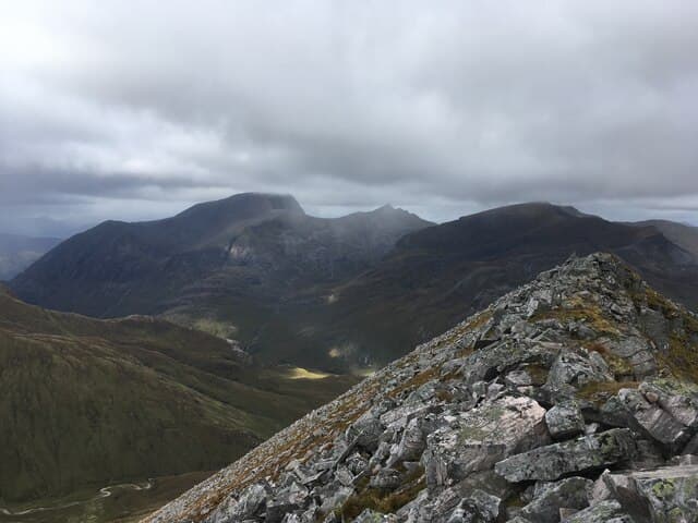
Binnein Mor is the highest of the Mamores at 1130m — the long sinuous chain of ten Munros that fills the country between Kinlochleven and Glen Nevis. The summit is a sharp pointed top reached by a narrow rocky ridge with serious exposure on the east side above Coire na Lochan. With 759m of prominence it stands clear of its Mamore neighbours and offers a striking near-equilateral pyramid profile from the south. Often climbed in tandem with its small but perfectly formed Munro cousin Binnein Beag.
Gaelic: “pointed peak, big” · Pronunciation: bin-yayn more
Quick facts
- Height
- 1130m/ 3707ft
- Prominence
- 759 m
- Distance
- 18 km
- Ascent
- 994 m
- Time
- 6–9 hrs
- Grid ref
- NN212663
- Parking
- NN187621
- Nearest city
- Fort William· 13km
- Dogs
- Dogs on lead required near livestockDog-friendly guide ↗
Height and prominence cross-checked against the Database of British and Irish Hills (CC BY).
No GPX track yet
Walked this route? Share your track to help other walkers.
Standard route
Glen track 30% · Open hillside 35% · Rocky ridge 35%
The classic line is from Kinlochleven, taking the path north up to the Loch Eilde Mor crossing, then climbing the south ridge of Binnein Mor via the Sgurr Eilde Beag bealach. Around 18km return with 994m of ascent. Often combined with Binnein Beag for an Eastern Mamores two-Munro day. Strong walkers continue along the Mamore ridge west over Na Gruagaichean and An Gearanach — the full Mamores Round is one of the great Lochaber traverses.
Terrain
The Loch Eilde Mor path is firm gravel. The climb up the south ridge is on heather and grass with rocky outcrops; the summit ridge is narrow and stony with significant exposure to the east. The summit cairn sits on a small rocky platform. The connection to Binnein Beag drops to a wide bealach then climbs steep rocky ground.
In winter
A serious winter mountain. The narrow summit ridge ices up readily and cornicing on the east side is consistent through the season. The Mamores cross-country traverse becomes a major undertaking. The Kinlochleven approach is reliable in winter; the B863 is gritted. SAIS Lochaber applies.
This hill is in the Glen Coe SAIS forecast area. Check SAIS forecasts in winter (December–April).
Best time of year
Getting there
- Glasgow2h 17m
- Edinburgh3h 58m
OS maps: OS Landranger 41
Mobile signal: No bars above 800m on most approaches from Kinlochleven or Mamore Lodge. The B863 Kinlochleven road has intermittent coverage. Download OS Maps offline before the drive.
Current conditions
Daylight Today
- Sunrise
- 05:03
- Sunset
- 21:50
- Civil dawn
- 04:08
- Civil dusk
- 22:45
NOAA Solar Calculator · 23 July 2026
Pair with
Curated multi-hill combinations from Binnein Mor.
Two-hill day
Binnein Mor + Binnein Beag
Classic pairing — Binnein Beag lies just to the north and is usually collected on the same outing via the connecting ridge from Binnein Mor's north top.
22km · 1400m ascent · 8 hrs
Two-hill day
Binnein Mor + Sgurr Eilde Mor
Sgurr Eilde Mor lies to the east; a long horseshoe round via Loch Eilde Mor takes in both peaks for a superb eastern Mamore day.
24km · 1600m ascent · 9 hrs
Around Binnein Mor on the SCOT network
Getting there, basing yourself, and what to do off the hill.
Getting there: Fort William station
Ben Nevis, Mamores, Aonachs, Knoydart ferry connection
13km from the hill
tripscot.co.uk
On TripSCOTBase yourself in Fort William
Ben Nevis base, West Highland Line, gateway to Lochaber
13km from the hill
tripscot.co.uk
On TasteSCOTAfter the hill: Ben Nevis Distillery
Fort William — Lochaber distillery at the foot of the Ben; long-aged Japanese-owned classics
13km from the hill
tastescot.co.uk
Binnein Mor — common questions
- What difficulty is Binnein Mor?
- On the OutdoorSCOT scale, Binnein Mor comes in at 4/5 — challenging. Expect roughly 18km and 994m of ascent on the usual route — 6-9 hours for most parties. Terrain: The Loch Eilde Mor path is firm gravel.
- How prominent is Binnein Mor?
- Binnein Mor has 759m of topographic prominence — the height of its summit above the highest col connecting it to higher ground.
- Where should I park to climb Binnein Mor?
- Standard parking is at NN187621. Check the parking grid reference on an OS map before travel; informal laybys can fill on summer weekends.
- When should I climb Binnein Mor?
- The standard good-weather months for Binnein Mor are May, June, July, August, September, October. Outside those months, expect winter conditions on the high ground — full mountain kit, navigation skills, and a check of the SAIS avalanche forecast for the relevant region.
- Can I bring my dog up Binnein Mor?
- On a lead only — the route crosses ground with livestock or nesting-bird interest.
- What's mobile reception like on Binnein Mor?
- No bars above 800m on most approaches from Kinlochleven or Mamore Lodge. The B863 Kinlochleven road has intermittent coverage. Download OS Maps offline before the drive.
- Is Binnein Mor safe in winter?
- A serious winter mountain. The narrow summit ridge ices up readily and cornicing on the east side is consistent through the season. The Mamores cross-country traverse becomes a major undertaking. The Kinlochleven approach is reliable in winter; the B863 is gritted. SAIS Lochaber applies.
Get the OutdoorSCOT weekly
One email a week — new route, hill and bothy guides, seasonal conditions and the odd hard-won lesson. No spam, unsubscribe in one click.