Munro · Glen Coe & Lochaber
Sgurr Eilde Mor
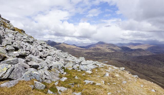
Sgùrr Eilde Mòr (1010m) — "big peak of the hinds" — is the easternmost Munro of the Mamores chain, sitting in its own corner above Loch Eilde Mòr and the head of Glen Nevis. The peak is the most isolated of the Mamores and gives commanding views across to the Grey Corries to the east and the Ring of Steall to the west. Most efficient as a pair with Binnein Beag to the west, or as part of a long six-Munro round of the eastern Mamores.
Gaelic: “sharp peak, big” · Pronunciation: skoor eilde more
Quick facts
- Height
- 1010m/ 3314ft
- Prominence
- 271 m
- Distance
- 17 km
- Ascent
- 889 m
- Time
- 5–8 hrs
- Grid ref
- NN230657
- Parking
- NN187622
- Nearest city
- Fort William· 15km
- Dogs
- Dogs on lead required near livestockDog-friendly guide ↗
Height and prominence cross-checked against the Database of British and Irish Hills (CC BY).
No GPX track yet
Walked this route? Share your track to help other walkers.
Standard route
Estate track 40% · Pathless hillside 35% · Rocky summit 25%
Start from Mamore Lodge above Kinlochleven (public footpath access; do not block the private road). Take the West Highland Way north for a short distance, then turn onto the high stalkers' path that contours along the south flank of the Mamores. Follow this east past Loch Eilde Mòr to the small lochan at the foot of Sgùrr Eilde Mòr, then climb the steep west ridge directly to the summit. Around 16km with 1100m of ascent — usually combined with Binnein Mòr or Binnein Beag.
Terrain
The Mamore Lodge access track is private — public footpath access only. The high stalkers' path contouring along the Mamores is one of the great Highland approach paths, well-built and easy underfoot. The Loch Eilde Mòr lochside is rough. The west ridge of Sgùrr Eilde Mòr is steep scree and broken quartzite — slippery on the descent. The summit is a small cairn perched at the edge of the steep north face.
In winter
A serious Mamores winter day with a long committing approach. The west ridge of Sgùrr Eilde Mòr becomes a steep snow climb in winter. The east-facing slopes hold significant avalanche risk after westerly storms. Cornicing along the summit ridge persists through the season. Kinlochleven on the south side offers some shelter and a sensible bail-out option. The relevant forecast is SAIS Lochaber; mobile reception fades above the 750m line.
This hill is in the Glen Coe SAIS forecast area. Check SAIS forecasts in winter (December–April).
Best time of year
Getting there
- Glasgow2h 16m
- Edinburgh3h 56m
OS maps: OS Landranger 41
Mobile signal: Signal vanishes above 750m on the eastern Mamore approaches. Kinlochleven has reasonable 4G. The Loch Eilde Mor track has very poor coverage throughout.
Current conditions
Daylight Today
- Sunrise
- 05:02
- Sunset
- 21:50
- Civil dawn
- 04:08
- Civil dusk
- 22:44
NOAA Solar Calculator · 23 July 2026
Pair with
Curated multi-hill combinations from Sgurr Eilde Mor.
Around Sgurr Eilde Mor on the SCOT network
Getting there, basing yourself, and what to do off the hill.
Getting there: Corrour station
Highest mainline station; Loch Ossian, Ben Alder, Aonach Beag (Alder)
13km from the hill
tripscot.co.uk
On TripSCOTBase yourself in Fort William
Ben Nevis base, West Highland Line, gateway to Lochaber
15km from the hill
tripscot.co.uk
On TasteSCOTAfter the hill: Ben Nevis Distillery
Fort William — Lochaber distillery at the foot of the Ben; long-aged Japanese-owned classics
15km from the hill
tastescot.co.uk
Sgurr Eilde Mor — common questions
- How difficult is Sgurr Eilde Mor?
- Sgurr Eilde Mor carries a 4/5 (challenging) grade on the OutdoorSCOT scale. Count on about 17km, 889m of ascent and a 5-8 hour day on the standard route. Terrain: The Mamore Lodge access track is private — public footpath access only.
- How prominent is Sgurr Eilde Mor?
- Sgurr Eilde Mor has 271m of topographic prominence — the height of its summit above the highest col connecting it to higher ground.
- Where should I park to climb Sgurr Eilde Mor?
- Standard parking is at NN187622. Check the parking grid reference on an OS map before travel; informal laybys can fill on summer weekends.
- When should I climb Sgurr Eilde Mor?
- The standard good-weather months for Sgurr Eilde Mor are May, June, July, August, September, October. Outside those months, expect winter conditions on the high ground — full mountain kit, navigation skills, and a check of the SAIS avalanche forecast for the relevant region.
- Can I bring my dog up Sgurr Eilde Mor?
- On a lead only — the route crosses ground with livestock or nesting-bird interest.
- What's mobile reception like on Sgurr Eilde Mor?
- Signal vanishes above 750m on the eastern Mamore approaches. Kinlochleven has reasonable 4G. The Loch Eilde Mor track has very poor coverage throughout.
- Is Sgurr Eilde Mor safe in winter?
- A serious Mamores winter day with a long committing approach. The west ridge of Sgùrr Eilde Mòr becomes a steep snow climb in winter. The east-facing slopes hold significant avalanche risk after westerly storms. Cornicing along the summit ridge persists through the season. Kinlochleven on the south side offers some shelter and a sensible bail-out option. The relevant forecast is SAIS Lochaber; mobile reception fades above the 750m line.
Get the OutdoorSCOT weekly
One email a week — new route, hill and bothy guides, seasonal conditions and the odd hard-won lesson. No spam, unsubscribe in one click.