Munro · Glen Coe & Lochaber
Am Bodach
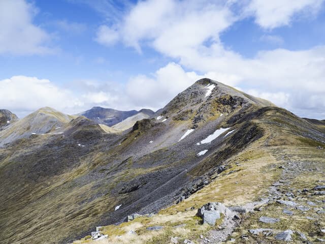
Am Bodach (1031m) — "the old man" — is the eastern bastion of the Ring of Steall in the Mamores, the celebrated four-Munro horseshoe above Glen Nevis. From its summit the famous Devil's Ridge curves west to Sgurr a' Mhaim, while the south-east ridge drops to the deep Coire a' Mhail. Despite its modest profile from Loch Leven, Am Bodach holds a key position on the Ring of Steall and gives commanding views over Ben Nevis to the north.
Quick facts
- Height
- 1031.8m/ 3385ft
- Prominence
- 153 m
- Distance
- 17 km
- Ascent
- 908 m
- Time
- 5–8 hrs
- Grid ref
- NN176650
- Parking
- NN145684
- Nearest city
- Fort William· 11km
- Dogs
- Dogs on lead required near livestockDog-friendly guide ↗
Height and prominence cross-checked against the Database of British and Irish Hills (CC BY).
No GPX track yet
Walked this route? Share your track to help other walkers.
Standard route
Steep ascent from valley 35% · Rocky ridge 40% · Summit area 25%
The standard line is the Ring of Steall from Polldubh in Glen Nevis, climbing An Gearanach via the east ridge, traversing west along the airy connecting ridges to An Garbhanach, Stob Coire a' Chairn, then up the steep east ridge to Am Bodach. Continue west over the Devil's Ridge to Sgurr a' Mhaim and descend back to Polldubh. Around 16km with 1500m of cumulative ascent for the four Munros. Direct Am Bodach only from Kinlochleven via Mamore Lodge is 11km with 950m up.
Terrain
The Polldubh wire footbridge over the River Nevis is well-maintained but slippery in spate. The climb onto Am Bodach from the Stob Coire a' Chairn bealach is steep grass and broken rock. The Devil's Ridge west of Am Bodach is the technical highlight of the Ring of Steall — a narrow rocky crest with one Grade 1 scrambling step that can be bypassed on the south. The summit itself is a small rocky platform.
In winter
A serious Mamores winter Munro. The Devil's Ridge becomes a true Grade I winter scramble with continuous exposure. The steep east ridge holds wind-loaded snow and the south face above Coire a' Mhail is avalanche-prone after westerly storms. Cornicing on the north sides of the summits is consistent. SAIS Lochaber applies. Phone signal is absent above 750m.
This hill is in the Glen Coe SAIS forecast area. Check SAIS forecasts in winter (December–April).
Best time of year
Getting there
- Glasgow2h 18m
- Edinburgh3h 0m
OS maps: OS Landranger 41
Mobile signal: Reasonable signal at Clachaig Inn. No signal on the Aonach Eagach ridge above 400m.
Current conditions
Daylight Today
- Sunrise
- 05:03
- Sunset
- 21:50
- Civil dawn
- 04:08
- Civil dusk
- 22:45
NOAA Solar Calculator · 23 July 2026
Pair with
Curated multi-hill combinations from Am Bodach.
Around Am Bodach on the SCOT network
Getting there, basing yourself, and what to do off the hill.
Getting there: Fort William station
Ben Nevis, Mamores, Aonachs, Knoydart ferry connection
11km from the hill
tripscot.co.uk
On TripSCOTBase yourself in Fort William
Ben Nevis base, West Highland Line, gateway to Lochaber
11km from the hill
tripscot.co.uk
On TasteSCOTAfter the hill: Ben Nevis Distillery
Fort William — Lochaber distillery at the foot of the Ben; long-aged Japanese-owned classics
12km from the hill
tastescot.co.uk
Am Bodach — common questions
- How difficult is Am Bodach?
- Am Bodach carries a 4/5 (challenging) grade on the OutdoorSCOT scale. Count on about 17km, 908m of ascent and a 5-8 hour day on the standard route. Ground conditions: The Polldubh wire footbridge over the River Nevis is well-maintained but slippery in spate.
- How much drop does Am Bodach have?
- The drop is 153m: measured from the summit of Am Bodach down to the saddle joining it to higher terrain.
- Where's the parking for Am Bodach?
- Park at NN145684. Double-check the grid reference on an OS map first; informal laybys here fill early in high season.
- What's the best month to climb Am Bodach?
- Aim for May, June, July, August, September, October on Am Bodach. In the remaining months treat it as a winter hill — full kit, solid navigation, and a look at the relevant SAIS avalanche forecast before you go.
- Can dogs go up Am Bodach?
- Dogs are fine on a lead. The route passes livestock or ground-nesting bird habitat, so keep them close throughout.
- Will I get phone signal on Am Bodach?
- Reasonable signal at Clachaig Inn. No signal on the Aonach Eagach ridge above 400m.
- Is Am Bodach safe in winter?
- A serious Mamores winter Munro. The Devil's Ridge becomes a true Grade I winter scramble with continuous exposure. The steep east ridge holds wind-loaded snow and the south face above Coire a' Mhail is avalanche-prone after westerly storms. Cornicing on the north sides of the summits is consistent. SAIS Lochaber applies. Phone signal is absent above 750m.
Get the OutdoorSCOT weekly
One email a week — new route, hill and bothy guides, seasonal conditions and the odd hard-won lesson. No spam, unsubscribe in one click.