Munro · Glen Coe & Lochaber
Sgurr a' Mhaim
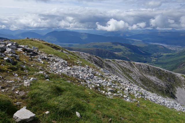
Sgurr a' Mhaim — "peak of the breast" — is the 1099m Munro that guards the western entrance to the Mamores, directly opposite Ben Nevis across Glen Nevis. The hill is famous for the Devil's Ridge — a narrow, exposed arête that connects to Stob Choire a' Mhail and forms the technical crux of the celebrated Ring of Steall round. A small cairn marks the rocky platform summit, with a near-vertical 900m drop down to the Steall meadows.
Quick facts
- Height
- 1099m/ 3606ft
- Prominence
- 316 m
- Distance
- 18 km
- Ascent
- 967 m
- Time
- 6–9 hrs
- Grid ref
- NN164667
- Parking
- NN167691
- Nearest city
- Fort William· 9km
- Dogs
- Dogs on lead required near livestockDog-friendly guide ↗
Height and prominence cross-checked against the Database of British and Irish Hills (CC BY).
No GPX track yet
Walked this route? Share your track to help other walkers.
Standard route
Steep hillside 40% · Rocky ridge 35% · Summit plateau 25%
The classic line is the Ring of Steall starting from Polldubh in Glen Nevis. Climb An Gearanach via the steep east ridge, traverse the airy ridge to An Garbhanach and Stob Coire a' Chairn, then continue north over Am Bodach and the Devil's Ridge to Sgurr a' Mhaim. Descent reverses the start. Around 16km return with 1500m of cumulative ascent over four Munros. Direct Sgurr a' Mhaim only is 8km with 967m up.
Terrain
The direct ascent from Polldubh is relentlessly steep grass and broken rock — 900m of climb in 2.5km. The Devil's Ridge is a Grade 1 scramble of narrow rocky crest with significant exposure on both sides; the hardest move can be skirted on the south side. The summit cairn sits on a small flat platform. The Glen Nevis river crossing on the standard Ring of Steall start uses a wire bridge.
In winter
A major winter mountaineering venue. The Devil's Ridge in winter is a Grade I/II climb with full alpine character; cornicing on the east side is severe. The Ring of Steall is a major day in winter — sustained ridge work and frequent crux moves. The east face holds Grade III-V ice climbs. SAIS Lochaber applies.
This hill is in the Glen Coe SAIS forecast area. Check SAIS forecasts in winter (December–April).
Best time of year
Getting there
- Glasgow2h 20m
- Edinburgh3h 3m
OS maps: OS Landranger 41
Mobile signal: No signal from the Devil's Ridge onwards. Glen Nevis car park has reasonable signal. Download the OS Landranger 41 offline before setting off — the Ring of Steall is too serious to navigate on mobile data alone.
Current conditions
Daylight Today
- Sunrise
- 05:03
- Sunset
- 21:50
- Civil dawn
- 04:08
- Civil dusk
- 22:45
NOAA Solar Calculator · 23 July 2026
Pair with
Curated multi-hill combinations from Sgurr a' Mhaim.
Around Sgurr a' Mhaim on the SCOT network
Getting there, basing yourself, and what to do off the hill.
Getting there: Fort William station
Ben Nevis, Mamores, Aonachs, Knoydart ferry connection
9km from the hill
tripscot.co.uk
On TripSCOTBase yourself in Fort William
Ben Nevis base, West Highland Line, gateway to Lochaber
9km from the hill
tripscot.co.uk
On TasteSCOTAfter the hill: Ben Nevis Distillery
Fort William — Lochaber distillery at the foot of the Ben; long-aged Japanese-owned classics
10km from the hill
tastescot.co.uk
Sgurr a' Mhaim — common questions
- What difficulty is Sgurr a' Mhaim?
- On the OutdoorSCOT scale, Sgurr a' Mhaim comes in at 4/5 — challenging. Expect roughly 18km and 967m of ascent on the usual route — 6-9 hours for most parties. Underfoot: The direct ascent from Polldubh is relentlessly steep grass and broken rock — 900m of climb in 2.
- What is Sgurr a' Mhaim's prominence?
- 316m of prominence. That's the vertical drop from the summit to the col that links Sgurr a' Mhaim to the next higher ground.
- Where do I park for Sgurr a' Mhaim?
- Most walkers start from NN167691. Verify the grid reference on an OS map before you set off — space is tight on busy summer weekends.
- When is the best time to climb Sgurr a' Mhaim?
- May, June, July, August, September, October give the most reliable conditions on Sgurr a' Mhaim. Beyond that window the high ground turns wintry: carry full mountain kit, be confident navigating, and check the SAIS avalanche forecast for the area.
- Is Sgurr a' Mhaim dog-friendly?
- Yes, but dogs must be kept on a lead — there is livestock or ground-nesting bird interest on the route.
- Is there mobile signal on Sgurr a' Mhaim?
- No signal from the Devil's Ridge onwards. Glen Nevis car park has reasonable signal. Download the OS Landranger 41 offline before setting off — the Ring of Steall is too serious to navigate on mobile data alone.
- Is Sgurr a' Mhaim safe in winter?
- A major winter mountaineering venue. The Devil's Ridge in winter is a Grade I/II climb with full alpine character; cornicing on the east side is severe. The Ring of Steall is a major day in winter — sustained ridge work and frequent crux moves. The east face holds Grade III-V ice climbs. SAIS Lochaber applies.
Get the OutdoorSCOT weekly
One email a week — new route, hill and bothy guides, seasonal conditions and the odd hard-won lesson. No spam, unsubscribe in one click.