Munro · Glen Coe & Lochaber
Stob Coire Sgreamhach
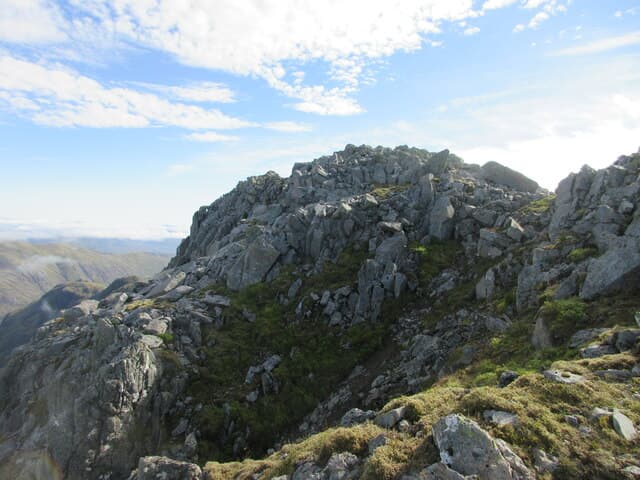
Stob Coire Sgreamhach (1072m) — "peak of the dreadful corrie" — is the eastern Munro of the Bidean nam Bian massif in Glen Coe, promoted to Munro status in the 1997 revision. It overlooks the Lost Valley (Coire Gabhail) and is connected by a sharp ridge to Bidean itself. Almost always climbed in tandem with Bidean nam Bian via the Lost Valley horseshoe, one of the great Glen Coe rounds.
Gaelic: “pointed peak, corrie” · Pronunciation: stob kor-a sgreamhach
Quick facts
- Height
- 1072m/ 3517ft
- Prominence
- 128 m
- Distance
- 18 km
- Ascent
- 943 m
- Time
- 6–9 hrs
- Grid ref
- NN154536
- Parking
- NN170568
- Nearest city
- Fort William· 21km
- Dogs
- Dogs on lead required near livestockDog-friendly guide ↗
Height and prominence cross-checked against the Database of British and Irish Hills (CC BY).
No GPX track yet
Walked this route? Share your track to help other walkers.
Standard route
Glen / corrie path 40% · Rocky hillside 35% · Summit area 25%
Start from the Lost Valley layby on the A82 in Glen Coe. Drop down to the River Coe via the bridge and climb through the wooded gorge into Coire Gabhail. From the flat valley floor climb the steep headwall (faint path, eroded scree) onto the Bealach Dearg, then take the rocky north-east ridge to Sgreamhach. Continue west to Bidean nam Bian, descend the south-west ridge to Stob Coire nan Lochan, and return down the Coire nan Lochan path. Around 11km with 940m of ascent.
Terrain
The Lost Valley path is rough — wet boulders, tree roots and a slabby step that needs care in descent. The Coire Gabhail floor is the famous flat moraine plain. The headwall climb to the Bealach Dearg is steep, eroded scree — loose and unpleasant in both directions. The Sgreamhach summit ridge is narrow with rocky steps; the connection to Bidean is an exposed rocky crest with one easy scramble.
In winter
A major Glencoe winter venue. The Lost Valley headwall is a recognised avalanche slope with serious incident history. Cornicing along the summit ridges of both Sgreamhach and Bidean is consistent through the season. The Sgreamhach–Bidean connecting ridge is a Grade I winter scramble. Full winter mountaineering kit and competence essential. SAIS Glencoe applies; the A82 is gritted.
This hill is in the Glen Coe SAIS forecast area. Check SAIS forecasts in winter (December–April).
Best time of year
Getting there
- Glasgow2h 6m
- Edinburgh3h 53m
OS maps: OS Landranger 41
Mobile signal: Moderate signal along the A82 in Glencoe. Barely anything above 700m.
Current conditions
Daylight Today
- Sunrise
- 05:04
- Sunset
- 21:50
- Civil dawn
- 04:09
- Civil dusk
- 22:44
NOAA Solar Calculator · 23 July 2026
Pair with
Curated multi-hill combinations from Stob Coire Sgreamhach.
Around Stob Coire Sgreamhach on the SCOT network
Getting there, basing yourself, and what to do off the hill.
Getting there: Bridge of Orchy station
Black Mount; Beinn Dorain, Beinn an Dothaidh, Beinn Achaladair, Beinn a Chreachain
20km from the hill
tripscot.co.uk
On TripSCOTBase yourself in Fort William
Ben Nevis base, West Highland Line, gateway to Lochaber
21km from the hill
tripscot.co.uk
On TasteSCOTAfter the hill: Ben Nevis Distillery
Fort William — Lochaber distillery at the foot of the Ben; long-aged Japanese-owned classics
23km from the hill
tastescot.co.uk
Stob Coire Sgreamhach — common questions
- Is Stob Coire Sgreamhach a hard climb?
- Stob Coire Sgreamhach is rated 4/5 (challenging) on the OutdoorSCOT scale. The standard route covers about 18km with 943m of ascent and takes most walkers 6-9 hours. Terrain: The Lost Valley path is rough — wet boulders, tree roots and a slabby step that needs care in descent.
- How prominent is Stob Coire Sgreamhach?
- Stob Coire Sgreamhach has 128m of topographic prominence — the height of its summit above the highest col connecting it to higher ground.
- Where should I park to climb Stob Coire Sgreamhach?
- Standard parking is at NN170568. Check the parking grid reference on an OS map before travel; informal laybys can fill on summer weekends.
- When should I climb Stob Coire Sgreamhach?
- The standard good-weather months for Stob Coire Sgreamhach are May, June, July, August, September, October. Outside those months, expect winter conditions on the high ground — full mountain kit, navigation skills, and a check of the SAIS avalanche forecast for the relevant region.
- Can I bring my dog up Stob Coire Sgreamhach?
- On a lead only — the route crosses ground with livestock or nesting-bird interest.
- What's mobile reception like on Stob Coire Sgreamhach?
- Moderate signal along the A82 in Glencoe. Barely anything above 700m.
- Is Stob Coire Sgreamhach safe in winter?
- A major Glencoe winter venue. The Lost Valley headwall is a recognised avalanche slope with serious incident history. Cornicing along the summit ridges of both Sgreamhach and Bidean is consistent through the season. The Sgreamhach–Bidean connecting ridge is a Grade I winter scramble. Full winter mountaineering kit and competence essential. SAIS Glencoe applies; the A82 is gritted.
Get the OutdoorSCOT weekly
One email a week — new route, hill and bothy guides, seasonal conditions and the odd hard-won lesson. No spam, unsubscribe in one click.