Munro · Glen Coe & Lochaber
Bidean nam Bian
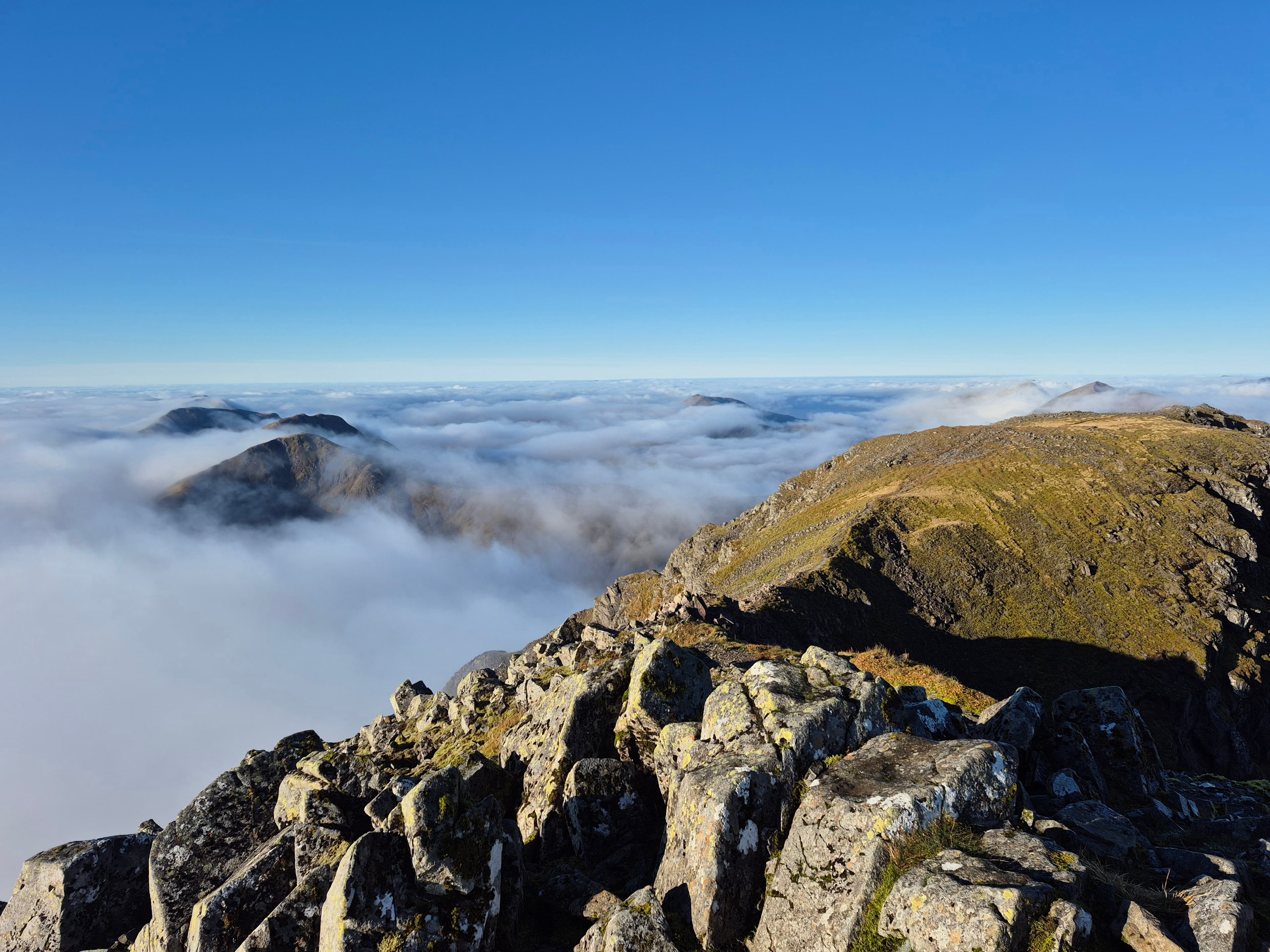
Bidean nam Bian — "peak of the mountains" — is the highest mountain in the old county of Argyll at 1150m and the heart of the Glen Coe massif. From the A82 the mountain is hidden behind the famous Three Sisters of Glen Coe (Beinn Fhada, Gearr Aonach, Aonach Dubh), and reaching the summit means climbing into the great hidden corries that hang above the road. The summit is a small rocky cairn on a slender ridge connecting multiple satellite tops; the position is one of the most dramatic of any Munro.
Quick facts
- Height
- 1149.4m/ 3771ft
- Prominence
- 844 m
- Distance
- 19 km
- Ascent
- 1011 m
- Time
- 6–9 hrs
- Grid ref
- NN143542
- Parking
- NN169569
- Nearest city
- Fort William· 20km
- Dogs
- Dogs on lead required near livestockDog-friendly guide ↗
Height and prominence cross-checked against the Database of British and Irish Hills (CC BY).
No GPX track yet
Walked this route? Share your track to help other walkers.
Standard route
Corrie path 30% · Rocky hillside / scramble 40% · Summit ridge 30%
The classic line is via the Lost Valley (Coire Gabhail) — start from the second car park on the A82 east of the Meeting of Three Waters, cross the river and climb the well-built path into the hanging corrie behind the Three Sisters. From the corrie head, climb steep grass and rock onto the Bidean ridge and traverse to the summit. Around 10km return with 1011m of ascent. Most parties combine with Stob Coire Sgreamhach for a two-Munro day.
Terrain
The Lost Valley path is well-built but the river crossing of the Allt Coire Gabhail can be impassable after rain. Above the corrie the climb is on steep grass and broken rock with intermittent path. The summit ridge is narrow with significant exposure on the north side. The connecting ridge to Stob Coire Sgreamhach drops to a wide bealach then climbs again on rock. Confident scrambling not required on the standard line but helpful.
In winter
A major Scottish winter mountaineering venue with continuous Grade I-V routes on Stob Coire nam Beith and the Diamond and Church Door buttresses. The Lost Valley headwall is a recognised avalanche slope after westerly storms with a serious history of incidents. Cornices form along the summit ridge. The A82 is gritted; Glencoe NTS visitor centre is open year-round. SAIS Glencoe applies.
This hill is in the Glen Coe SAIS forecast area. Check SAIS forecasts in winter (December–April).
Best time of year
Getting there
- Glasgow2h 7m
- Edinburgh3h 55m
OS maps: OS Landranger 41
Mobile signal: Moderate signal at the Glencoe NTS Visitor Centre and along the A82. Signal absent above the treeline in Coire nan Lochan. No signal on summit.
Current conditions
Daylight Today
- Sunrise
- 05:04
- Sunset
- 21:50
- Civil dawn
- 04:09
- Civil dusk
- 22:44
NOAA Solar Calculator · 23 July 2026
Pair with
Curated multi-hill combinations from Bidean nam Bian.
Around Bidean nam Bian on the SCOT network
Getting there, basing yourself, and what to do off the hill.
Getting there: Fort William station
Ben Nevis, Mamores, Aonachs, Knoydart ferry connection
20km from the hill
tripscot.co.uk
On TripSCOTBase yourself in Fort William
Ben Nevis base, West Highland Line, gateway to Lochaber
20km from the hill
tripscot.co.uk
On TasteSCOTAfter the hill: Ben Nevis Distillery
Fort William — Lochaber distillery at the foot of the Ben; long-aged Japanese-owned classics
22km from the hill
tastescot.co.uk
Bidean nam Bian — common questions
- How hard is Bidean nam Bian?
- We grade Bidean nam Bian at 4/5, which puts it in challenging territory. The usual route is around 19km with 1011m of climbing; allow 6-9 hours. Ground conditions: The Lost Valley path is well-built but the river crossing of the Allt Coire Gabhail can be impassable after rain.
- How much drop does Bidean nam Bian have?
- The drop is 844m: measured from the summit of Bidean nam Bian down to the saddle joining it to higher terrain.
- Where's the parking for Bidean nam Bian?
- Park at NN169569. Double-check the grid reference on an OS map first; informal laybys here fill early in high season.
- What's the best month to climb Bidean nam Bian?
- Aim for May, June, July, August, September, October on Bidean nam Bian. In the remaining months treat it as a winter hill — full kit, solid navigation, and a look at the relevant SAIS avalanche forecast before you go.
- Can dogs go up Bidean nam Bian?
- Dogs are fine on a lead. The route passes livestock or ground-nesting bird habitat, so keep them close throughout.
- Will I get phone signal on Bidean nam Bian?
- Moderate signal at the Glencoe NTS Visitor Centre and along the A82. Signal absent above the treeline in Coire nan Lochan. No signal on summit.
- Is Bidean nam Bian safe in winter?
- A major Scottish winter mountaineering venue with continuous Grade I-V routes on Stob Coire nam Beith and the Diamond and Church Door buttresses. The Lost Valley headwall is a recognised avalanche slope after westerly storms with a serious history of incidents. Cornices form along the summit ridge. The A82 is gritted; Glencoe NTS visitor centre is open year-round. SAIS Glencoe applies.
Get the OutdoorSCOT weekly
One email a week — new route, hill and bothy guides, seasonal conditions and the odd hard-won lesson. No spam, unsubscribe in one click.