Graham · Glen Coe & Lochaber
Beinn na Gucaig
Beinn na Gucaig (616m) rises directly above the village of Onich in the NN06 square, looking across the Corran Narrows to Ardgour and south down Loch Linnhe. The bare ground at the summit gives a fine seat for taking in the Ballachulish Munros and the Pap of Glencoe. Its prominence is unusually high for a hill of this stature, making the climb feel more substantial than the bald figures suggest.
Quick facts
- Height
- 616m/ 2021ft
- Prominence
- 451 m
- Distance
- 12 km
- Ascent
- 462 m
- Time
- 3–5 hrs
- Grid ref
- NN062653
- Parking
- NN079652
- Nearest city
- Fort William· 10km
- Dogs
- Dogs on lead required near livestockDog-friendly guide ↗
Height and prominence cross-checked against the Database of British and Irish Hills (CC BY).
No GPX track yet
Walked this route? Share your track to help other walkers.
Standard route
heather and bog 60% · rocky slopes 25% · grass slopes 15%
From the layby at NN079652 just east of Onich, follow the forest track up through the conifers before breaking out onto open hillside above 250m. The ascent line follows the west ridge directly to the summit, crossing boggy mid-slopes and rising onto firmer ground higher up. Round trip about five hours; the descent reverses the climb because the south face drops abruptly to the loch.
Terrain
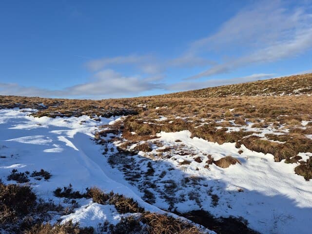
Conifer plantation tracks for the lower stretch, then boggy heather and bracken once on the open hill. The upper west ridge is broken outcrop and short heather. The southern flank above the A82 is steep and crag-broken — keep west of the summit if descending in mist.
In winter
Onich sits in the rain shadow of Glen Coe but Beinn na Gucaig still catches Atlantic snow that lingers on its upper outcrops. The west ridge can be wind-scoured into icy ribs. SAIS Glen Coe covers the snow and avalanche picture; the steep southern face is the chief concern in deep snow.
This hill is in the Glen Coe SAIS forecast area. Check SAIS forecasts in winter (December–April).
Best time of year
Getting there
- Glasgow2h 24m
- Edinburgh3h 53m
OS maps: OS Landranger 41
Mobile signal: Variable. EE reliable in Onich; intermittent higher up.
Current conditions
Daylight Today
- Sunrise
- 04:47
- Sunset
- 22:06
- Civil dawn
- 03:47
- Civil dusk
- 23:05
NOAA Solar Calculator · 13 July 2026
Around Beinn na Gucaig on the SCOT network
Getting there, basing yourself, and what to do off the hill.
Getting there: Fort William station
Ben Nevis, Mamores, Aonachs, Knoydart ferry connection
9km from the hill
tripscot.co.uk
On TripSCOTBase yourself in Fort William
Ben Nevis base, West Highland Line, gateway to Lochaber
10km from the hill
tripscot.co.uk
On TasteSCOTAfter the hill: Ben Nevis Distillery
Fort William — Lochaber distillery at the foot of the Ben; long-aged Japanese-owned classics
12km from the hill
tastescot.co.uk
Beinn na Gucaig — common questions
- How hard is Beinn na Gucaig?
- We grade Beinn na Gucaig at 3/5, which puts it in moderately challenging territory. The usual route is around 12km with 462m of climbing; allow 3-5 hours. Underfoot: Conifer plantation tracks for the lower stretch, then boggy heather and bracken once on the open hill.
- What is Beinn na Gucaig's prominence?
- 451m of prominence. That's the vertical drop from the summit to the col that links Beinn na Gucaig to the next higher ground.
- Where do I park for Beinn na Gucaig?
- Most walkers start from NN079652. Verify the grid reference on an OS map before you set off — space is tight on busy summer weekends.
- When is the best time to climb Beinn na Gucaig?
- March, April, May, June, July, August, September, October, November give the most reliable conditions on Beinn na Gucaig. Beyond that window the high ground turns wintry: carry full mountain kit, be confident navigating, and check the SAIS avalanche forecast for the area.
- Is Beinn na Gucaig dog-friendly?
- Yes, but dogs must be kept on a lead — there is livestock or ground-nesting bird interest on the route.
- Is there mobile signal on Beinn na Gucaig?
- Variable. EE reliable in Onich; intermittent higher up.
- Is Beinn na Gucaig safe in winter?
- Onich sits in the rain shadow of Glen Coe but Beinn na Gucaig still catches Atlantic snow that lingers on its upper outcrops. The west ridge can be wind-scoured into icy ribs. SAIS Glen Coe covers the snow and avalanche picture; the steep southern face is the chief concern in deep snow.
Get the OutdoorSCOT weekly
One email a week — new route, hill and bothy guides, seasonal conditions and the odd hard-won lesson. No spam, unsubscribe in one click.