Munro · Glen Coe & Lochaber
Stob a' Choire Mheadhoin
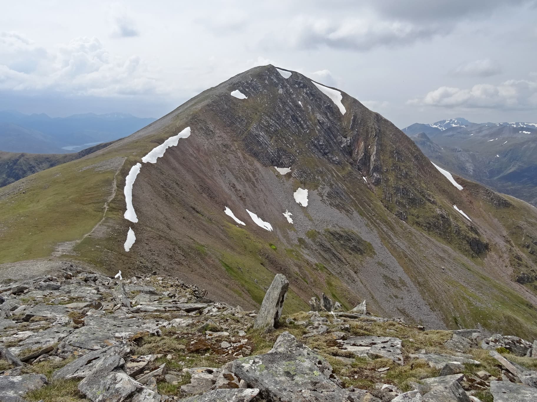
Stob a' Choire Mheadhoin is the 1106m Munro that pairs with Stob Coire Easain to form the "Easains" — the twin peaks rising directly above the west shore of Loch Treig. Slightly lower and rougher than its twin, its summit cairn sits on a rocky platform with steep ground falling east into Loch Treig and the great Allt Coire Easain corrie. The hill is rarely climbed alone; the standard outing combines both Easains in a high-level circuit from Fersit.
Gaelic: “pointed peak, of the, corrie” · Pronunciation: stob uh chor-a mheadhoin
Quick facts
- Height
- 1105m/ 3625ft
- Prominence
- 140 m
- Distance
- 18 km
- Ascent
- 972 m
- Time
- 6–9 hrs
- Grid ref
- NN316736
- Parking
- NN350782
- Nearest city
- Fort William· 21km
- Dogs
- Dogs on lead required near livestockDog-friendly guide ↗
Height and prominence cross-checked against the Database of British and Irish Hills (CC BY).
No GPX track yet
Walked this route? Share your track to help other walkers.
Standard route
Track / loch-side path 35% · Steep hillside 30% · Summit ridge 35%
Start from Fersit beside the West Highland Line and follow the track south along Loch Treig before climbing west onto the prominent north ridge of Stob a' Choire Mheadhoin. From the summit, traverse the broad ridge south-west to Stob Coire Easain. Around 17km return with 972m of net ascent for the pair. Best done as a clear-weather circuit — the ridge between the two Easains is broad but featureless in mist.
Terrain
The Fersit track is firm gravel to the lochside, then degrades to rough heather and wet ground above. The north ridge is steep grass and broken rock — no scrambling but slow going. The summit area is a small rocky cairn on broken ground. The connecting ridge to Stob Coire Easain is broad short grass with one shallow bealach to cross.
In winter
A serious winter outing in remote country. Cornicing on the east edges above Loch Treig is consistent through the season; avalanche risk on the north-east face. The Fersit road is single-track and rarely gritted in winter. Phone signal is absent above the road. SAIS Lochaber applies.
This hill is in the Glen Coe SAIS forecast area. Check SAIS forecasts in winter (December–April).
Best time of year
Getting there
- Glasgow2h 22m
- Edinburgh3h 55m
OS maps: OS Landranger 41
Mobile signal: Signal vanishes above 700m. The Fersit road end has patchy signal. Tulloch station (West Highland Line) is the nearest civilisation and has limited coverage.
Current conditions
Daylight Today
- Sunrise
- 05:01
- Sunset
- 21:50
- Civil dawn
- 04:06
- Civil dusk
- 22:45
NOAA Solar Calculator · 23 July 2026
Pair with
Curated multi-hill combinations from Stob a' Choire Mheadhoin.
Around Stob a' Choire Mheadhoin on the SCOT network
Getting there, basing yourself, and what to do off the hill.
Getting there: Tulloch station
Loch Treig; Beinn na Lap; Stob Coire Easain / Stob a Choire Mheadhoin approach
5km from the hill
tripscot.co.uk
On TripSCOTBase yourself in Fort William
Ben Nevis base, West Highland Line, gateway to Lochaber
21km from the hill
tripscot.co.uk
On TasteSCOTAfter the hill: Ben Nevis Distillery
Fort William — Lochaber distillery at the foot of the Ben; long-aged Japanese-owned classics
20km from the hill
tastescot.co.uk
Stob a' Choire Mheadhoin — common questions
- Is Stob a' Choire Mheadhoin a hard climb?
- Stob a' Choire Mheadhoin is rated 3/5 (moderately challenging) on the OutdoorSCOT scale. The standard route covers about 18km with 972m of ascent and takes most walkers 6-9 hours. Ground conditions: The Fersit track is firm gravel to the lochside, then degrades to rough heather and wet ground above.
- How much drop does Stob a' Choire Mheadhoin have?
- The drop is 140m: measured from the summit of Stob a' Choire Mheadhoin down to the saddle joining it to higher terrain.
- Where's the parking for Stob a' Choire Mheadhoin?
- Park at NN350782. Double-check the grid reference on an OS map first; informal laybys here fill early in high season.
- What's the best month to climb Stob a' Choire Mheadhoin?
- Aim for May, June, July, August, September, October on Stob a' Choire Mheadhoin. In the remaining months treat it as a winter hill — full kit, solid navigation, and a look at the relevant SAIS avalanche forecast before you go.
- Can dogs go up Stob a' Choire Mheadhoin?
- Dogs are fine on a lead. The route passes livestock or ground-nesting bird habitat, so keep them close throughout.
- Will I get phone signal on Stob a' Choire Mheadhoin?
- Signal vanishes above 700m. The Fersit road end has patchy signal. Tulloch station (West Highland Line) is the nearest civilisation and has limited coverage.
- Is Stob a' Choire Mheadhoin safe in winter?
- A serious winter outing in remote country. Cornicing on the east edges above Loch Treig is consistent through the season; avalanche risk on the north-east face. The Fersit road is single-track and rarely gritted in winter. Phone signal is absent above the road. SAIS Lochaber applies.
Get the OutdoorSCOT weekly
One email a week — new route, hill and bothy guides, seasonal conditions and the odd hard-won lesson. No spam, unsubscribe in one click.