Corbett · Central Highlands
Gairbeinn
Gairbeinn — 'the rough hill' — is the 895m Corbett rising at the eastern edge of the Glen Roy and Loch Lochy hills, between Glen Spean and the Great Glen. The summit forms the high point of a broad ridge running west-east, with views over the Great Glen to the south-west and across to the Monadh Liath plateau to the east. Reached most directly from the Spean Bridge area via the long Glen Roy parallel-roads road. A quiet hill in the lived-in country of Lochaber's eastern frontier.
Quick facts
- Height
- 895.5m/ 2938ft
- Prominence
- 211 m
- Distance
- 11 km
- Ascent
- 650 m
- Time
- 3–5 hrs
- Grid ref
- NN460985
- Parking
- NN458963
- Nearest city
- Fort William· 43km
- Dogs
- Dogs on lead required near livestockDog-friendly guide ↗
Height and prominence cross-checked against the Database of British and Irish Hills (CC BY).
No GPX track yet
Walked this route? Share your track to help other walkers.
Standard route
military road 20% · bog and grass 45% · plateau heather 25% · summit area 10%
Park at the small layby near Melgarve at the head of Glen Roy (NN458963), at the end of the Glen Roy public road. Take the estate track east-north-east, climbing onto the broad south ridge of Gairbeinn. The route follows the ridge to the summit cairn after a sustained pull on heather and grass. For an extended day, continue east to Corrieyairack Hill. Allow 5–6 hours.
Terrain
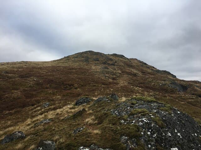
Estate track on the approach. Above the track, mixed heather and grass cover the broad ridge with peat hags lying in the lower bealachs. A small cairn perches on a rocky outcrop at the high point. Drier than the western Corbetts because of the Glen Roy rain shadow position.
In winter
Snow lies long on the upper ridge from January through March. Cold easterly winds funnel along the Corrieyairack Pass; the broad summit is exposed. No avalanche concerns on the standard ascent line. The Glen Roy road can be slow when iced.
This hill is in the Creag Meagaidh SAIS forecast area. Check SAIS forecasts in winter (December–April).
Best time of year
Getting there
- Glasgow3h 51m
- Edinburgh3h 9m
OS maps: OS Landranger 34
Mobile signal: No signal on this remote Corrieyairack plateau hill
Current conditions
Daylight Today
- Sunrise
- 04:42
- Sunset
- 22:05
- Civil dawn
- 03:41
- Civil dusk
- 23:07
NOAA Solar Calculator · 13 July 2026
Around Gairbeinn on the SCOT network
Getting there, basing yourself, and what to do off the hill.
Getting there: Dalwhinnie station
Highest mainline station; Drumochter Munros; Ben Alder approach
22km from the hill
tripscot.co.uk
On TripSCOTBase yourself in Fort William
Ben Nevis base, West Highland Line, gateway to Lochaber
43km from the hill
tripscot.co.uk
On TasteSCOTAfter the hill: Dalwhinnie
Dalwhinnie — Scotland's highest distillery on the Drumochter pass
22km from the hill
tastescot.co.uk
Gairbeinn — common questions
- How hard is Gairbeinn?
- We grade Gairbeinn at 2/5, which puts it in moderate territory. The usual route is around 11km with 650m of climbing; allow 3-5 hours. Ground conditions: Estate track on the approach.
- How much drop does Gairbeinn have?
- The drop is 211m: measured from the summit of Gairbeinn down to the saddle joining it to higher terrain.
- Where's the parking for Gairbeinn?
- Park at NN458963. Double-check the grid reference on an OS map first; informal laybys here fill early in high season.
- What's the best month to climb Gairbeinn?
- Aim for May, June, July, August, September, October on Gairbeinn. In the remaining months treat it as a winter hill — full kit, solid navigation, and a look at the relevant SAIS avalanche forecast before you go.
- Can dogs go up Gairbeinn?
- Dogs are fine on a lead. The route passes livestock or ground-nesting bird habitat, so keep them close throughout.
- Will I get phone signal on Gairbeinn?
- No signal on this remote Corrieyairack plateau hill
- Is Gairbeinn safe in winter?
- Snow lies long on the upper ridge from January through March. Cold easterly winds funnel along the Corrieyairack Pass; the broad summit is exposed. No avalanche concerns on the standard ascent line. The Glen Roy road can be slow when iced.
Get the OutdoorSCOT weekly
One email a week — new route, hill and bothy guides, seasonal conditions and the odd hard-won lesson. No spam, unsubscribe in one click.