Graham · Central Highlands
Glas-bheinn Mhor
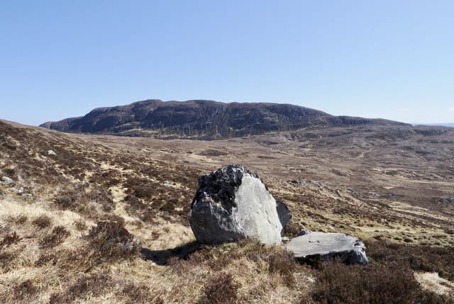
Glas-bheinn Mhor (651m) — the big grey hill — sits south of Strathconon in the NH43 square between the River Meig and Loch Luichart. The flat rocky summit looks east toward the Affric watershed and north back across Strathconon to Beinn Mheadhoin and An Sidhean.
Gaelic: “grey-green, big” · Pronunciation: glass bheinn vore
Quick facts
- Height
- 651m/ 2136ft
- Prominence
- 156 m
- Distance
- 13 km
- Ascent
- 534 m
- Time
- 4–6 hrs
- Grid ref
- NH436231
- Parking
- NH377551
- Nearest city
- Inverness· 32km
- Dogs
- Dogs on lead required near livestockDog-friendly guide ↗
Height and prominence cross-checked against the Database of British and Irish Hills (CC BY).
No GPX track yet
Walked this route? Share your track to help other walkers.
Standard route
heather and bog 65% · grass slopes 25% · rocky summit 10%
Start from the small lay-by at Strathconon Lodge. Cross the bridge over the Meig and follow the estate track south-east, then strike up the broad north spur on rough grass and bog. The angle eases on the upper plateau; aim for the highest of the scattered rock outcrops to reach the cairnless top.
Terrain
Hard estate track then trackless grass and peat on the north spur. The summit plateau is a flat tableland of grass and lichen-spotted rock — a compass bearing helps confirm the high point.
In winter
The Strathconon hills hold modest snowpack but the plateau plays tricks in flat light when wind crusts the ground. Glas-bheinn Mhor's open top picks up easterly drift from the Affric divide; spikes are usually enough but the lack of features makes navigation the chief concern.
This hill is in the Creag Meagaidh SAIS forecast area. Check SAIS forecasts in winter (December–April).
Best time of year
Getting there
- Glasgow3h 3m
- Edinburgh3h 16m
OS maps: OS Landranger 26
Mobile signal: Poor. Remote upper Strathconon area; weak on all networks.
Current conditions
Daylight Today
- Sunrise
- 04:41
- Sunset
- 22:07
- Civil dawn
- 03:39
- Civil dusk
- 23:09
NOAA Solar Calculator · 13 July 2026
On a long-distance route
Glas-bheinn Mhor sits within 5km of these named long-distance walks — useful for trail-pack rest days or section extensions.
Around Glas-bheinn Mhor on the SCOT network
Getting there, basing yourself, and what to do off the hill.
Getting there: Inverness station
Highland capital — Cairngorms east side, Affric, Far North via bus/car
32km from the hill
tripscot.co.uk
On TripSCOTBase yourself in Inverness
Highland capital — gateway to Cairngorms, Affric, Far North
32km from the hill
tripscot.co.uk
On TasteSCOTAfter the hill: Glen Ord
Muir of Ord — Black Isle distillery; the Singleton range's Highland anchor
29km from the hill
tastescot.co.uk
Glas-bheinn Mhor — common questions
- Is Glas-bheinn Mhor a hard climb?
- Glas-bheinn Mhor is rated 4/5 (challenging) on the OutdoorSCOT scale. The standard route covers about 13km with 534m of ascent and takes most walkers 4-6 hours. Ground conditions: Hard estate track then trackless grass and peat on the north spur.
- How much drop does Glas-bheinn Mhor have?
- The drop is 156m: measured from the summit of Glas-bheinn Mhor down to the saddle joining it to higher terrain.
- Where's the parking for Glas-bheinn Mhor?
- Park at NH377551. Double-check the grid reference on an OS map first; informal laybys here fill early in high season.
- What's the best month to climb Glas-bheinn Mhor?
- Aim for March, April, May, June, July, August, September, October, November on Glas-bheinn Mhor. In the remaining months treat it as a winter hill — full kit, solid navigation, and a look at the relevant SAIS avalanche forecast before you go.
- Can dogs go up Glas-bheinn Mhor?
- Dogs are fine on a lead. The route passes livestock or ground-nesting bird habitat, so keep them close throughout.
- Will I get phone signal on Glas-bheinn Mhor?
- Poor. Remote upper Strathconon area; weak on all networks.
- Is Glas-bheinn Mhor safe in winter?
- The Strathconon hills hold modest snowpack but the plateau plays tricks in flat light when wind crusts the ground. Glas-bheinn Mhor's open top picks up easterly drift from the Affric divide; spikes are usually enough but the lack of features makes navigation the chief concern.
Get the OutdoorSCOT weekly
One email a week — new route, hill and bothy guides, seasonal conditions and the odd hard-won lesson. No spam, unsubscribe in one click.