Graham · Central Highlands
Meall Fuar-mhonaidh
Meall Fuar-mhonaidh (698m) — the lump of the cold moor — is the highest point on the south-west side of Loch Ness, set in the NH42 square above Drumnadrochit. Its trig pillar offers what some claim is the finest view in the Great Glen: the loch stretching forty miles to Inverness with the Affric peaks beyond.
Gaelic: “rounded hill, moor” · Pronunciation: myowl fuar mhonaidh
Quick facts
- Height
- 698.4m/ 2291ft
- Prominence
- 233 m
- Distance
- 13 km
- Ascent
- 572 m
- Time
- 4–6 hrs
- Grid ref
- NH457222
- Parking
- NH428221
- Nearest city
- Inverness· 31km
- Dogs
- Dogs on lead required near livestockDog-friendly guide ↗
Height and prominence cross-checked against the Database of British and Irish Hills (CC BY).
No GPX track yet
Walked this route? Share your track to help other walkers.
Standard route
heather moorland 65% · bog and wet grass 25% · rocky summit 10%
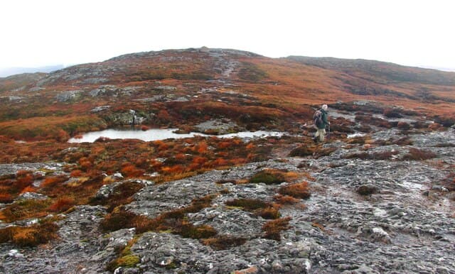
From the layby at Bunloit follow the well-signed path west through birch wood and rough grazing onto open hill. A clear path climbs the east ridge with one short rocky step at 600m before the broad shoulder rolls out to the trig. Return by the same route or extend west to Carn na Leitire.
Terrain
Birch wood and farm track give way to a maintained but boggy path through heather. The east ridge has one small rocky step easily turned on the left. The summit shoulder is cropped turf with conspicuous schist outcrops near the trig.
In winter
The Great Glen funnels arctic easterlies and Meall Fuar-mhonaidh lives up to its cold name. Snow lies in pockets into May and the exposed summit can be brutal in any north-easterly. Avalanche risk is negligible but wind chill on the trig has been measured below -25C in February.
This hill is in the Creag Meagaidh SAIS forecast area. Check SAIS forecasts in winter (December–April).
Best time of year
Getting there
- Glasgow3h 1m
- Edinburgh3h 14m
OS maps: OS Landranger 26
Mobile signal: Poor. Remote south Glenmoriston location; signal unreliable.
Current conditions
Daylight Today
- Sunrise
- 04:47
- Sunset
- 22:01
- Civil dawn
- 03:47
- Civil dusk
- 23:01
NOAA Solar Calculator · 17 July 2026
On a long-distance route
Meall Fuar-mhonaidh sits within 5km of these named long-distance walks — useful for trail-pack rest days or section extensions.
Around Meall Fuar-mhonaidh on the SCOT network
Getting there, basing yourself, and what to do off the hill.
Getting there: Inverness station
Highland capital — Cairngorms east side, Affric, Far North via bus/car
31km from the hill
tripscot.co.uk
On TripSCOTBase yourself in Inverness
Highland capital — gateway to Cairngorms, Affric, Far North
31km from the hill
tripscot.co.uk
On TasteSCOTAfter the hill: Glen Ord
Muir of Ord — Black Isle distillery; the Singleton range's Highland anchor
29km from the hill
tastescot.co.uk
Meall Fuar-mhonaidh — common questions
- Is Meall Fuar-mhonaidh a hard climb?
- Meall Fuar-mhonaidh is rated 4/5 (challenging) on the OutdoorSCOT scale. The standard route covers about 13km with 572m of ascent and takes most walkers 4-6 hours. Ground conditions: Birch wood and farm track give way to a maintained but boggy path through heather.
- How much drop does Meall Fuar-mhonaidh have?
- The drop is 233m: measured from the summit of Meall Fuar-mhonaidh down to the saddle joining it to higher terrain.
- Where's the parking for Meall Fuar-mhonaidh?
- Park at NH428221. Double-check the grid reference on an OS map first; informal laybys here fill early in high season.
- What's the best month to climb Meall Fuar-mhonaidh?
- Aim for March, April, May, June, July, August, September, October, November on Meall Fuar-mhonaidh. In the remaining months treat it as a winter hill — full kit, solid navigation, and a look at the relevant SAIS avalanche forecast before you go.
- Can dogs go up Meall Fuar-mhonaidh?
- Dogs are fine on a lead. The route passes livestock or ground-nesting bird habitat, so keep them close throughout.
- Will I get phone signal on Meall Fuar-mhonaidh?
- Poor. Remote south Glenmoriston location; signal unreliable.
- Is Meall Fuar-mhonaidh safe in winter?
- The Great Glen funnels arctic easterlies and Meall Fuar-mhonaidh lives up to its cold name. Snow lies in pockets into May and the exposed summit can be brutal in any north-easterly. Avalanche risk is negligible but wind chill on the trig has been measured below -25C in February.
Get the OutdoorSCOT weekly
One email a week — new route, hill and bothy guides, seasonal conditions and the odd hard-won lesson. No spam, unsubscribe in one click.