Corbett · Central Highlands
Sgorr na Diollaid
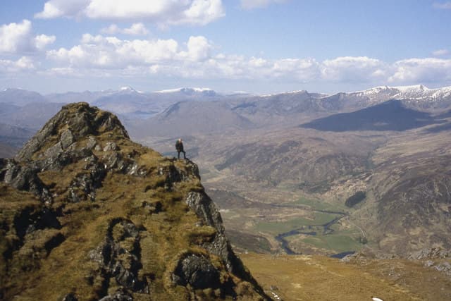
Sgorr na Diollaid — "peak of the saddle", a reference to the broad bealach on the summit ridge — sits between Glen Cannich and Glen Strathfarrar, on the high ground north of Loch Mullardoch. At 817m the hill is a quiet Corbett tucked among the great Munros of the Mullardoch and Strathfarrar ridges, often overlooked but with a striking rock tor at the highest point. The view south across Loch Mullardoch to the high Affric ridge is the highlight, and the relative isolation gives a real sense of central Highland wilderness.
Quick facts
- Height
- 817.9m/ 2683ft
- Prominence
- 306 m
- Distance
- ~15 km
- Ascent
- ~719 m
- Time
- 4–7 hrs
- Grid ref
- NH281362
- Parking
- NH253333
- Nearest city
- Inverness· 39km
- Dogs
- Dogs on lead required near livestockDog-friendly guide ↗
Height and prominence cross-checked against the Database of British and Irish Hills (CC BY).
No GPX track yet
Walked this route? Share your track to help other walkers.
Standard route
estate track 25% · rough heather 40% · broad ridge 25% · rock tor 10%
Start from the small parking area at the road end in Glen Cannich beyond Cozac Lodge and follow the estate track north-east into the upper glen. Some 3km up the glen, step off the track and pull north-west onto the broad south ridge of Sgorr na Diollaid on pathless heather. An even-graded climb up the ridge reaches the rock-tor summit. Day works out at around 15km out-and-back and 719m of climbing. Surrounding country is rough and pathless, so the hill is normally tackled on its own.
Terrain
The Glen Cannich estate track is firm and easy underfoot. Off the track the ground is rough trackless heather and peat hag — slow but never technical. The summit ridge is broad short grass with the rock tor at the highest point distinctive enough to be unmissable even in mist. The drop into Glen Strathfarrar to the north is steep and crag-broken; keep south on descent.
In winter
A reasonably serious winter Corbett because of the remoteness rather than the technical ground. The hill itself has gentle gradients and no avalanche slopes; the Glen Cannich road can drift up and Cozac Lodge is at the end of a single-track route that closes after heavy snowfall. Phone signal is absent throughout. The rock tor in rime is a striking sight.
Kit for this: the winter Munro kit list · which boots take crampons
Best time of year
Getting there
- Glasgow3h 20m
- Edinburgh4h 38m
OS maps: OS Landranger 25
Mobile signal: No coverage in upper Glen Cannich; nothing on the hill
Current conditions
Daylight Today
- Sunrise
- 07:50
- Sunset
- 18:21
- Civil dawn
- 07:11
- Civil dusk
- 19:00
NOAA Solar Calculator · 14 October 2026
Pair with
Curated multi-hill combinations from Sgorr na Diollaid.
Around Sgorr na Diollaid on the SCOT network
Getting there, basing yourself, and what to do off the hill.
Getting there: Dingwall station
Ben Wyvis approach; Easter Ross; junction for Kyle and Far North lines
35km from the hill
tripscot.co.uk
On TripSCOTBase yourself in Inverness
Highland capital — gateway to Cairngorms, Affric, Far North
39km from the hill
tripscot.co.uk
On TasteSCOTAfter the hill: Glen Ord
Muir of Ord — Black Isle distillery; the Singleton range's Highland anchor
29km from the hill
tastescot.co.uk
Sgorr na Diollaid — common questions
- What difficulty is Sgorr na Diollaid?
- On the OutdoorSCOT scale, Sgorr na Diollaid comes in at 3/5 — moderately challenging. Expect roughly 15km and 719m of ascent on the usual route — 4-7 hours for most parties. Terrain: The Glen Cannich estate track is firm and easy underfoot.
- How prominent is Sgorr na Diollaid?
- Sgorr na Diollaid has 306m of topographic prominence — the height of its summit above the highest col connecting it to higher ground.
- Where should I park to climb Sgorr na Diollaid?
- Standard parking is at NH253333. Check the parking grid reference on an OS map before travel; informal laybys can fill on summer weekends.
- When should I climb Sgorr na Diollaid?
- The standard good-weather months for Sgorr na Diollaid are April, May, June, July, August, September, October. Outside those months, expect winter conditions on the high ground — full mountain kit, navigation skills, and a check of the SAIS avalanche forecast for the relevant region.
- Can I bring my dog up Sgorr na Diollaid?
- On a lead only — the route crosses ground with livestock or nesting-bird interest.
- What's mobile reception like on Sgorr na Diollaid?
- No coverage in upper Glen Cannich; nothing on the hill
- Is Sgorr na Diollaid safe in winter?
- A reasonably serious winter Corbett because of the remoteness rather than the technical ground. The hill itself has gentle gradients and no avalanche slopes; the Glen Cannich road can drift up and Cozac Lodge is at the end of a single-track route that closes after heavy snowfall. Phone signal is absent throughout. The rock tor in rime is a striking sight.
Get the OutdoorSCOT weekly
One email a week — new route, hill and bothy guides, seasonal conditions and the odd hard-won lesson. No spam, unsubscribe in one click.