Munro · Central Highlands
Sgurr nan Conbhairean
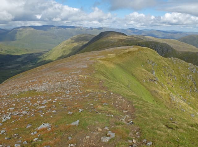
Sgurr nan Conbhairean — "peak of the dog-keepers" — is the 1109m Munro on the north side of Loch Cluanie, the highest of three Munros in the rolling country between Glen Affric and Glen Moriston. The summit area carries both a large cairn and a small windshelter, with views south across Loch Cluanie to the Five Sisters of Kintail and north into the Affric wilderness. Often combined with Carn Ghluasaid and Sail Chaorainn for a three-Munro round.
Quick facts
- Height
- 1109m/ 3638ft
- Prominence
- 382 m
- Distance
- 18 km
- Ascent
- 976 m
- Time
- 7–10 hrs
- Grid ref
- NH129138
- Parking
- NH154104
- Nearest city
- Fort William· 40km
- Dogs
- Dogs on lead required near livestockDog-friendly guide ↗
Height and prominence cross-checked against the Database of British and Irish Hills (CC BY).
No GPX track yet
Walked this route? Share your track to help other walkers.
Standard route
Cluanie Inn path 25% · Open hillside / ridge 40% · Summit 35%
The classic line is from the lay-by on the A87 at the Cluanie Inn end of Loch Cluanie. Take the old military road past the dam to climb the long south ridge of Carn Ghluasaid, then traverse the broad ridge north over Sgurr nan Conbhairean to Sail Chaorainn. Around 18km return with 976m of ascent. Strong walkers extend the traverse to include the smaller Carn na Coinnich.
Terrain
The old military road is firm gravel. The climb onto Carn Ghluasaid is on rough heather and grass. The connecting ridges are broad grassy walking with no exposure. The summit area has both a large cairn and a small stone shelter; the high point is between the two. Easy ground throughout in clear weather.
In winter
A moderate winter Munro round. The summit ridge picks up snow but no avalanche slopes of consequence on the standard line. Cornicing on the north sides facing Glen Affric. The A87 itself is gritted reliably but the lay-by ices over. SAIS Northern Highlands applies.
This hill is in the Creag Meagaidh SAIS forecast area. Check SAIS forecasts in winter (December–April).
Best time of year
Getting there
- Glasgow3h 59m
- Edinburgh3h 27m
OS maps: OS Landranger 34
Mobile signal: No coverage above 700m above Loch Cluanie. The Cluanie Inn has reasonable 4G. Save maps ahead of heading into the hills.
Current conditions
Daylight Today
- Sunrise
- 05:01
- Sunset
- 21:53
- Civil dawn
- 04:04
- Civil dusk
- 22:49
NOAA Solar Calculator · 23 July 2026
Pair with
Curated multi-hill combinations from Sgurr nan Conbhairean.
On a long-distance route
Sgurr nan Conbhairean sits within 5km of these named long-distance walks — useful for trail-pack rest days or section extensions.
Around Sgurr nan Conbhairean on the SCOT network
Getting there, basing yourself, and what to do off the hill.
Sgurr nan Conbhairean — common questions
- What difficulty is Sgurr nan Conbhairean?
- On the OutdoorSCOT scale, Sgurr nan Conbhairean comes in at 3/5 — moderately challenging. Expect roughly 18km and 976m of ascent on the usual route — 7-10 hours for most parties. Ground conditions: The old military road is firm gravel.
- How much drop does Sgurr nan Conbhairean have?
- The drop is 382m: measured from the summit of Sgurr nan Conbhairean down to the saddle joining it to higher terrain.
- Where's the parking for Sgurr nan Conbhairean?
- Park at NH154104. Double-check the grid reference on an OS map first; informal laybys here fill early in high season.
- What's the best month to climb Sgurr nan Conbhairean?
- Aim for May, June, July, August, September, October on Sgurr nan Conbhairean. In the remaining months treat it as a winter hill — full kit, solid navigation, and a look at the relevant SAIS avalanche forecast before you go.
- Can dogs go up Sgurr nan Conbhairean?
- Dogs are fine on a lead. The route passes livestock or ground-nesting bird habitat, so keep them close throughout.
- Will I get phone signal on Sgurr nan Conbhairean?
- No coverage above 700m above Loch Cluanie. The Cluanie Inn has reasonable 4G. Save maps ahead of heading into the hills.
- Is Sgurr nan Conbhairean safe in winter?
- A moderate winter Munro round. The summit ridge picks up snow but no avalanche slopes of consequence on the standard line. Cornicing on the north sides facing Glen Affric. The A87 itself is gritted reliably but the lay-by ices over. SAIS Northern Highlands applies.
Get the OutdoorSCOT weekly
One email a week — new route, hill and bothy guides, seasonal conditions and the odd hard-won lesson. No spam, unsubscribe in one click.