Munro · Central Highlands
Mullach Fraoch-choire
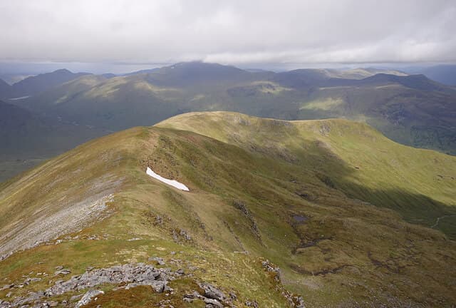
Mullach Fraoch-choire — "summit of the heathery corrie" — is the 1101m Munro north of A' Chralaig, the second peak on the rolling ridge between Glen Cluanie and Glen Affric. The summit carries a stone windshelter on a small rocky platform, with the unusual feature of a series of small pinnacles along the connecting ridge to A' Chralaig — one of the more interesting traverses in the area. Almost always done in tandem with A' Chralaig from the Cluanie Inn.
Gaelic: “summit, corrie” · Pronunciation: mull-ach fraoch chor-a
Quick facts
- Height
- 1100.9m/ 3612ft
- Prominence
- 151 m
- Distance
- 18 km
- Ascent
- 969 m
- Time
- 7–10 hrs
- Grid ref
- NH094171
- Parking
- NH090118
- Nearest city
- Fort William· 43km
- Dogs
- Dogs on lead required near livestockDog-friendly guide ↗
Height and prominence cross-checked against the Database of British and Irish Hills (CC BY).
No GPX track yet
Walked this route? Share your track to help other walkers.
Standard route
Cluanie approach path 25% · Open hillside 35% · Summit ridge 40%
The standard line is from the Cluanie Inn lay-by on the A87, climbing A' Chralaig first via its north-east ridge then continuing north along the connecting ridge over the pinnacles to Mullach Fraoch-choire. Descent reverses the line, or extends down the An Caorann Mor path back to the road. Around 18km return with 969m of ascent for the pair.
Terrain
The A' Chralaig climb starts pathless from the A87 on steep grass. The connecting ridge has a series of small rocky pinnacles that can be scrambled or bypassed on the west side — Grade 1 if taken direct. The summit area is a windshelter on a small platform; the ground is short grass with rocky outcrops.
In winter
A serious winter ridge. The pinnacles become a Grade I winter scramble with cornicing on the east side. Avalanche risk on the east-facing slopes after westerly storms. The A87 itself is reliably gritted; the lay-by tends to ice. SAIS Northern Highlands applies.
This hill is in the Creag Meagaidh SAIS forecast area. Check SAIS forecasts in winter (December–April).
Best time of year
Getting there
- Glasgow3h 4m
- Edinburgh4h 32m
OS maps: OS Landranger 33
Mobile signal: Signal vanishes above 700m at Loch Cluanie. Cluanie Inn has reasonable signal. Get mapping saved before the walk-in.
Current conditions
Daylight Today
- Sunrise
- 05:01
- Sunset
- 21:54
- Civil dawn
- 04:04
- Civil dusk
- 22:50
NOAA Solar Calculator · 23 July 2026
Pair with
Curated multi-hill combinations from Mullach Fraoch-choire.
Around Mullach Fraoch-choire on the SCOT network
Getting there, basing yourself, and what to do off the hill.
Mullach Fraoch-choire — common questions
- Is Mullach Fraoch-choire a hard climb?
- Mullach Fraoch-choire is rated 5/5 (very challenging) on the OutdoorSCOT scale. The standard route covers about 18km with 969m of ascent and takes most walkers 7-10 hours. Terrain: The A' Chralaig climb starts pathless from the A87 on steep grass.
- How prominent is Mullach Fraoch-choire?
- Mullach Fraoch-choire has 151m of topographic prominence — the height of its summit above the highest col connecting it to higher ground.
- Where should I park to climb Mullach Fraoch-choire?
- Standard parking is at NH090118. Check the parking grid reference on an OS map before travel; informal laybys can fill on summer weekends.
- When should I climb Mullach Fraoch-choire?
- The standard good-weather months for Mullach Fraoch-choire are May, June, July, August, September, October. Outside those months, expect winter conditions on the high ground — full mountain kit, navigation skills, and a check of the SAIS avalanche forecast for the relevant region.
- Can I bring my dog up Mullach Fraoch-choire?
- On a lead only — the route crosses ground with livestock or nesting-bird interest.
- What's mobile reception like on Mullach Fraoch-choire?
- Signal vanishes above 700m at Loch Cluanie. Cluanie Inn has reasonable signal. Get mapping saved before the walk-in.
- Is Mullach Fraoch-choire safe in winter?
- A serious winter ridge. The pinnacles become a Grade I winter scramble with cornicing on the east side. Avalanche risk on the east-facing slopes after westerly storms. The A87 itself is reliably gritted; the lay-by tends to ice. SAIS Northern Highlands applies.
Get the OutdoorSCOT weekly
One email a week — new route, hill and bothy guides, seasonal conditions and the odd hard-won lesson. No spam, unsubscribe in one click.