Region
Skye & the Small Isles
The Black Cuillin is the finest mountain ridge in Britain — and Rum, Eigg, and Muck are worth the ferry on their own.
- Munros
- 12
- Corbetts
- 4
- Grahams
- 11
- Bothies
- 7
- Long-distance trails
- 1
- Wild swimming
- 4
- Gravel routes
- 2
- Dark sky sites
- 3
- Highest peak
- Sgurr Alasdair (992m)
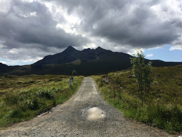
Skye divides into two completely different places, geographically and experientially. The Black Cuillin in the south is a gabbro ridge of twelve Munros — the only ridge in Britain where every summit requires scrambling or climbing to reach, and where the magnetic rock means compasses are unreliable. The rest of Skye — the Trotternish peninsula in the north with the Quiraing and the Old Man of Storr, the Waternish and Duirinish peninsulas in the west, the Sleat peninsula in the south — is gentler, coastal, and equally dramatic in different ways. These are two separate destinations sharing an island.
The Cuillin is not for everyone. Sgurr nan Gillean, Bruach na Frithe, and the Inaccessible Pinnacle cannot be reached on foot without using hands on rock — the question is not whether to scramble but how committed that scrambling needs to be. The Inn Pinn (Sgurr Dearg) requires a genuine rock climb to summit. The full Cuillin Ridge Traverse — all twelve Munros in one continuous push — is a multi-pitch climbing undertaking that the fastest parties complete in under three hours and most guided trips take two days. If your experience is walking rather than climbing, stick to the north of the island and save the Cuillin for when you've developed the skills.
The Small Isles — Rum, Eigg, Muck, and Canna — are reached by CalMac ferry from Mallaig. Rum is the wildest: a mountain wilderness run as a National Nature Reserve with a small population and the magnificent Kinloch Castle (now in disrepair). Eigg has the best general walking, a thriving community, and the extraordinary Singing Sands beach. Muck is tiny, friendly, and relaxing. Canna has seabirds. All four are worth a night at minimum.
Glens2 glen guides
All glens →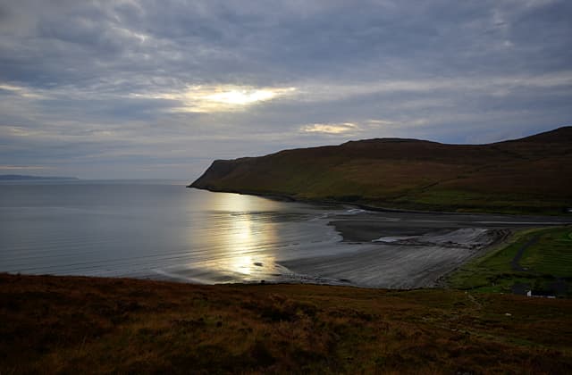
Glen Brittle
The Cuillin's back door — fairy pools at the entrance, serious gabbro peaks at the head, and midges that will find you in both places.
Glen Sligachan
The glen that divides the Red and Black Cuillin — the most photographed bridge in Scotland at its entrance and one of the great wilderness walks at its far end.
Hills12 Munros · 4 Corbetts · 11 Grahams
Sgurr Alasdair
992m
Sgurr Dearg - Inaccessible Pinnacle
985.8m
Sgurr a' Ghreadaidh
972.1m
Sgurr nan Gillean
966.1m
Sgurr na Banachdich (Sgurr na Banachdaich)
965m
Bruach na Frithe
958.8m
Sgurr Mhic Choinnich
948.1m
Sgurr Dubh Mor
944.1m
Am Basteir
934m
Blabheinn (Bla Bheinn)
928.8m
Long-distance trails
Bothies7 in this region
Wild swimming4 spots
Gravel cycling2 routes
Wild camping
Dark sky & northern lights3 sites
Map
Hills (dark/mid green), bothies (brown), wild swimming (blue), dark sky (purple).
Getting there
Inverness
2.5 hr drive
Glasgow
4 hr drive
Edinburgh
4 hr drive
CalMac ferry
Ferry required for island access
Guided support for Skye & the Small Isles
If you'd prefer a guided experience, these operators run trips in this area.
Wilderness Scotland
Premium guided expeditions, all regions
Macs Adventure
Self-guided LDP specialists
Hillwalk Tours
Self-guided routes, luggage transfer
Absolute Escapes
Edinburgh-based independent operator
Affiliate links — disclosure
Our take
The Storr and the Quiraing are overrun — not just busy but genuinely unpleasant on a summer weekend, with the car parks full by 8am and the paths eroded by the volume of visitors. Go in October or April if you want to see them properly, or get there at dawn in summer. The Old Man of Storr photograph that's on every Scottish tourism poster was taken in the early morning; the reality of July at noon involves queuing for the path.
For the Cuillin, hire a guide for your first serious day. Not because the terrain is beyond you, but because local knowledge genuinely changes the experience — knowing which descent involves loose scree and which involves solid rock, where the reliable water sources are, and how to read Cuillin weather (which arrives fast and from the west). Skye Guides are the established local outfit. A good day on Bruach na Frithe with a guide is more rewarding than a miserable self-navigated grind up Sgurr nan Gillean in poor conditions.
Track your Skye & the Small Isles hills
Log your completions across the Skye & the Small Isles hills and plan your next route.
Open Hill Tracker →Explore nearby regions
Scotland outdoor updates
Route guides, condition reports and seasonal picks — once a week, no noise.
Around Skye & the Small Isles on the SCOT network
Sister sites covering food, drink and travel context for the same area. Linked direct.
Islands whisky region
12 distilleries from Orkney to Arran — maritime character, Talisker, Highland Park, Harris.
tastescot.co.uk
On TripSCOTPortree
Main Skye base — Cuillin, Trotternish, Storr
tripscot.co.uk
On TripSCOTMallaig
Ferry port for Skye and the Small Isles; CWT finish supply
tripscot.co.uk
On TripSCOTIsle of Skye
Cuillin, Trotternish, Quiraing, Storr — Britain's most dramatic island
tripscot.co.uk