Long distance
Skye Trail
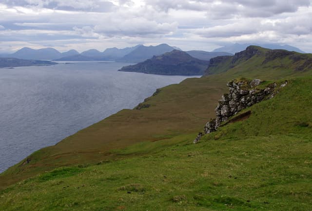
An unofficial trail traversing the Isle of Skye from its northernmost tip to Broadford. Passes the Quiraing, Trotternish Ridge, and the Cuillin foothills through some of the most dramatic landscape in Britain. Stretches 128 km (80 mi) and around 4,500 m of climbing; most parties take 7 days walking best north-to-south — a committing multi-day route.
Quick facts
- Distance
- 128 km/ 80 mi
- Typical days
- 7
- Total ascent
- 4500 m
- Difficulty
- challenging
- Start → Finish
- Rubha Hunish → Broadford
- Best direction
- North to South
- Water sources
- Rubha Hunish, Flodigarry, Portree, Sligachan, Elgol and Broadford have tap water. The Trotternish ridge and Bla Bheinn sections are demanding — burns are frequent but exposed to sheep. Treat all water. Carry 2L for the ridge crossings.
- Mobile signal
- EE/Vodafone in Portree, Sligachan, Broadford and most settlements. The Trotternish ridge crossing is out of signal for most of the day. The Cuillin / Bla Bheinn section is largely signal-free; expect coverage only at Sligachan.
⚠ Not waymarked — navigation skills required
Approximate profile derived from per-stage ascent — accurate on total climb and pattern, not a pixel-precise GPX trace.
Our take
The Skye Trail is not a waymarked path — it is a linked series of routes through terrain that punishes the unprepared. The Trotternish Ridge section is exposed and serious in poor weather. The Cuillin approach is rough and boggy. Weather on Skye is famously hostile. But on a clear day there is nowhere in Scotland more spectacular. Navigation skills are essential. Midges in July are biblical.
Highlights
- The Quiraing
- Trotternish Ridge traverse
- Old Man of Storr
- Views into the Black Cuillin from Sligachan
Day-by-day itinerary
A suggested 7-day schedule. Adjust to your fitness and conditions.
1Rubha Hunish to Flodigarry12km · 400m ascent
From the northernmost point of Skye along dramatic sea cliffs to Flodigarry. The views to the Outer Hebrides are immense on a clear day.
- Terrain
- Cliff-top paths, rough moorland, steep descent. Exposed.
- Overnight
- Flodigarry Hotel and hostel. Wild camping on the clifftops.
- Stats
- Rubha Hunish → Flodigarry · 12km · ↑400m
2Flodigarry to Uig20km · 750m ascent
The Quiraing traverse — one of the most spectacular walks in Scotland. Bizarre pinnacles and landslip terrain. Then descend to Uig's sheltered bay.
- Terrain
- Mountain ridge, landslip terrain, steep paths. Navigation essential in mist.
- Overnight
- Uig has a hotel, B&Bs and a campsite. CalMac ferry terminal for the Outer Hebrides.
- Stats
- Flodigarry → Uig · 20km · ↑750m
3Uig to The Storr22km · 800m ascent
Along the Trotternish Ridge — exposed and serious in poor weather but sensational on a clear day. The Old Man of Storr is the climax.
- Terrain
- Mountain ridge, exposed plateau, rocky paths. Serious navigation in cloud.
- Overnight
- Wild camping near the Storr car park. No facilities on the ridge.
- Stats
- Uig → The Storr · 22km · ↑800m
4The Storr to Portree14km · 300m ascent
Descend from the Storr through forest to Portree, the capital of Skye. A rest and resupply day in a colourful harbour town.
- Terrain
- Forest paths, quiet roads, town walking.
- Overnight
- Portree has hotels, hostels, B&Bs and restaurants. Book ahead in summer.
- Stats
- The Storr → Portree · 14km · ↑300m
5Portree to Sligachan22km · 600m ascent
Across moorland and through Glen Sligachan with the Black Cuillin ridge growing ever more dramatic ahead. The Sligachan Hotel is a legendary stop.
- Terrain
- Moorland paths, glen tracks, boggy sections.
- Overnight
- Sligachan Hotel and campsite. The bar has 400 malts.
- Stats
- Portree → Sligachan · 22km · ↑600m
6Sligachan to Elgol22km · 700m ascent
Through the Cuillin foothills via the Camasunary coast path or over the high pass of Am Mam. The views of the Cuillin from Elgol are legendary.
- Terrain
- Mountain paths, coastal walking, rough ground. Some scrambling on the coast route.
- Overnight
- Elgol has limited B&Bs. Wild camping at Camasunary bay.
- Stats
- Sligachan → Elgol · 22km · ↑700m
7Elgol to Broadford16km · 400m ascent
The final day along the coast and through the moor to Broadford. A gentler finish after the Cuillin drama.
- Terrain
- Coastal paths, moorland, quiet road walking.
- Overnight
- Broadford has hotels, B&Bs and the Broadford Hotel bar. Bus connections across Skye.
- Stats
- Elgol → Broadford · 16km · ↑400m
Hills along the route
Munros, Corbetts, Grahams and Donalds within 5km of the route line — extensions or rest-day options.
Transport
To start (Rubha Hunish)
Bus · Scottish Citylink 915/916
Glasgow / Fort William to Portree (Skye)
Several daily
Check times & book →Bus · Stagecoach 57A
Portree to Duntulm (for Rubha Hunish start)
Several daily
Final 2 miles on foot from road to Rubha Hunish headland
Check times & book →
From finish (Broadford)
Bus · Scottish Citylink 915/916 / Stagecoach 52
Broadford to Inverness / Glasgow via Skye Bridge
Several daily
Check times & book →Ferry · CalMac
Armadale (Skye) to Mallaig — alternative onward via West Highland Line
Several daily, seasonal
Check times & book →
Best months
Accommodation
Mix of wild camping, hostels (Uig, Portree, Sligachan) and B&Bs. Book Portree well ahead in summer. Mix of wild camping, hostels (Uig SYHA, Portree Backpackers, Broadford Backpackers) and B&Bs; pre-book Portree at least three months ahead in summer as it fills with coach tourism.
Night-by-night guide: where to stay →Resupply
Uig, Portree and Sligachan are the main resupply points. Carry 2 days of food for the southern sections. Uig, Portree and Broadford have Co-op or local shops; Sligachan Hotel sells limited supplies and breakfast. The longest gap is around 50km between Uig and Portree.
Current conditions
Weather at the start point (Rubha Hunish)
Daylight Today
- Sunrise
- 05:16
- Sunset
- 21:48
- Civil dawn
- 04:22
- Civil dusk
- 22:42
NOAA Solar Calculator · 30 July 2026
Share your experience
Walked the Skye Trail? Help others plan their trip.
Getting to and from the Skye Trail
Train and town anchors at each end of the route — on TripSCOT.