Graham · Skye & The Small Isles
Hartaval
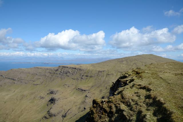
Hartaval (669m) sits on the great Trotternish escarpment in the NG45 square, the second-highest summit on the ridge after The Storr. The cairn perches on the broad grass dome behind the basalt cliffs, looking east to Raasay and the mainland and west across the moors to the Western Isles. Always overshadowed by its more famous neighbour but a finer summit in its own right.
Quick facts
- Height
- 669m/ 2195ft
- Prominence
- 180 m
- Distance
- 13 km
- Ascent
- 549 m
- Time
- 4–6 hrs
- Grid ref
- NG480551
- Parking
- NG486545
- Nearest
- Ullapool
- Dogs
- Dogs on lead required near livestockDog-friendly guide ↗
Height and prominence cross-checked against the Database of British and Irish Hills (CC BY).
No GPX track yet
Walked this route? Share your track to help other walkers.
Standard route
grass slopes 55% · rocky outcrops 30% · heather patches 15%
Park at the Storr car park on the A855 north of Portree and follow the tourist path to the Old Man pinnacles. Continue past Coire Faoin onto the open hillside and climb the south spur of The Storr, traversing the summit before dropping to the col with Hartaval. The grassy north ridge then leads in a gentle arc to the cairn — the descent reverses the line or escapes east via the Bealach Beag.
Terrain
Eroded tourist path through the Storr forestry, then short grass and exposed basalt onto the summit dome. The Trotternish ridge crest is broad and easy walking but the cliff edge to the east is unfenced and lethal in cloud. Watch the cornice line on the basalt scarp.
In winter
Trotternish ridge winters bring savage Atlantic gales and the basalt scarp builds substantial east-facing cornices. The grass slopes ice up quickly. Cloud sits on the ridge for days at a time — patience and a good compass are essential. SAIS does not cover Skye.
Best time of year
Getting there
- Glasgow4h 13m
- Edinburgh5h 52m
OS maps: OS Landranger 23
Mobile signal: Poor. Trotternish Ridge, Skye; signal is marginal here.
Current conditions
Daylight Today
- Sunrise
- 04:52
- Sunset
- 22:10
- Civil dawn
- 03:51
- Civil dusk
- 23:11
NOAA Solar Calculator · 17 July 2026
Pair with
Curated multi-hill combinations from Hartaval.
On a long-distance route
Hartaval sits within 5km of these named long-distance walks — useful for trail-pack rest days or section extensions.
Around Hartaval on the SCOT network
Getting there, basing yourself, and what to do off the hill.
Getting there: Kyle of Lochalsh station
Skye Bridge; Five Sisters of Kintail; Glen Shiel; Plockton
39km from the hill
tripscot.co.uk
On TripSCOTBase yourself in Portree
Main Skye base — Cuillin, Trotternish, Storr
11km from the hill
tripscot.co.uk
On TasteSCOTAfter the hill: Isle of Raasay Distillery
Raasay — new island distillery with rooms; Dun Caan walks from the door
20km from the hill
tastescot.co.uk
Hartaval — common questions
- How hard is Hartaval?
- We grade Hartaval at 4/5, which puts it in challenging territory. The usual route is around 13km with 549m of climbing; allow 4-6 hours. Underfoot: Eroded tourist path through the Storr forestry, then short grass and exposed basalt onto the summit dome.
- What is Hartaval's prominence?
- 180m of prominence. That's the vertical drop from the summit to the col that links Hartaval to the next higher ground.
- Where do I park for Hartaval?
- Most walkers start from NG486545 near Ullapool. Verify the grid reference on an OS map before you set off — space is tight on busy summer weekends.
- When is the best time to climb Hartaval?
- May, June, July, August, September give the most reliable conditions on Hartaval. Beyond that window the high ground turns wintry: carry full mountain kit, be confident navigating, and check the SAIS avalanche forecast for the area.
- Is Hartaval dog-friendly?
- Yes, but dogs must be kept on a lead — there is livestock or ground-nesting bird interest on the route.
- Is there mobile signal on Hartaval?
- Poor. Trotternish Ridge, Skye; signal is marginal here.
- Is Hartaval safe in winter?
- Trotternish ridge winters bring savage Atlantic gales and the basalt scarp builds substantial east-facing cornices. The grass slopes ice up quickly. Cloud sits on the ridge for days at a time — patience and a good compass are essential. SAIS does not cover Skye.
Get the OutdoorSCOT weekly
One email a week — new route, hill and bothy guides, seasonal conditions and the odd hard-won lesson. No spam, unsubscribe in one click.