Corbett · Skye & The Small Isles
Glamaig - Sgurr Mhairi
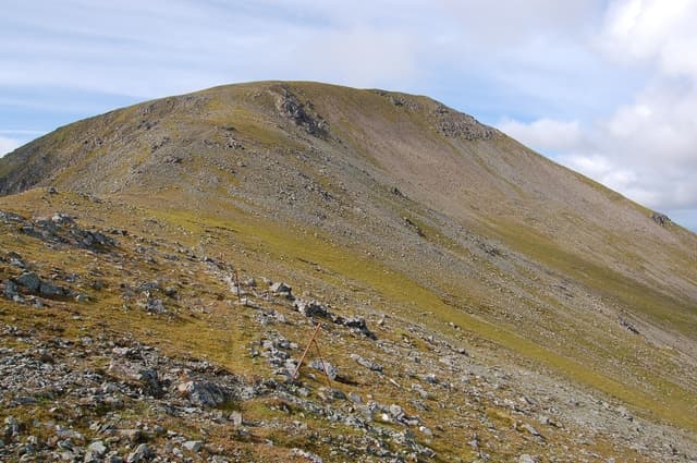
Glamaig is the conical Red Cuillin dome rising directly above the Sligachan Hotel on Skye — visible from the moment you cross the Skye Bridge and a landmark from across the Inner Sound on the mainland. The Corbett summit, Sgùrr Mhàiri at 775m, is gained via what is by general agreement the steepest sustained ascent of any standard route in Scotland: 750m of climb in less than two horizontal kilometres on red granite scree. The Glamaig Hill Race held each July sees the top runners summit-to-pub in under 50 minutes; mortals take 4–5 hours.
Quick facts
- Height
- 775m/ 2543ft
- Prominence
- 485 m
- Distance
- 6 km
- Ascent
- 770 m
- Time
- 2–4 hrs
- Grid ref
- NG513300
- Parking
- NG486298
- Nearest
- Fort William
- Dogs
- Dogs on lead required near livestockDog-friendly guide ↗
Height and prominence cross-checked against the Database of British and Irish Hills (CC BY).
No GPX track yet
Walked this route? Share your track to help other walkers.
Standard route
moorland path 15% · red scree 45% · rocky ridge 30% · summit dome 10%
Start at the Sligachan Hotel car park (NG486298) — pay-and-display, busy in summer. Cross the road and join the path that runs east up the open moor toward the foot of the hill. The route is unrelenting once it starts: a direct line up the western flank of Glamaig over scree and red granite to the broad summit. There is no easy line; the gradient is what it is. Descent is unpleasantly fast on the same scree. Allow 3.5–5 hours.
Terrain
Moorland for the first kilometre — wet, peaty. The main slope is loose red granite scree from around 300m to the summit ridge — slow on the up, fast and risky on the down. The summit area is broader and rockier, with a clear cairn. No path of consequence below the moor or on the upper scree; pick the best line.
In winter
In winter the scree slope freezes into a treacherous mix of iced rock and verglassed grass — significantly more dangerous than it appears from the road. Glamaig has produced winter walking accidents disproportionate to its understated altitude for exactly this reason. Best left until spring unless conditions are firm, with crampons and axe carried.
Best time of year
Getting there
- Glasgow4h 47m
- Edinburgh4h 29m
OS maps: OS Landranger 32
Mobile signal: Reasonable EE/Vodafone at Sligachan; weakens on the ascent but recovers on the summit given clear sight of Portree
Current conditions
Daylight Today
- Sunrise
- 04:47
- Sunset
- 22:13
- Civil dawn
- 03:45
- Civil dusk
- 23:16
NOAA Solar Calculator · 13 July 2026
Around Glamaig - Sgurr Mhairi on the SCOT network
Getting there, basing yourself, and what to do off the hill.
Getting there: Kyle of Lochalsh station
Skye Bridge; Five Sisters of Kintail; Glen Shiel; Plockton
25km from the hill
tripscot.co.uk
On TripSCOTBase yourself in Portree
Main Skye base — Cuillin, Trotternish, Storr
14km from the hill
tripscot.co.uk
On TasteSCOTAfter the hill: Isle of Raasay Distillery
Raasay — new island distillery with rooms; Dun Caan walks from the door
7km from the hill
tastescot.co.uk
Glamaig - Sgurr Mhairi — common questions
- Is Glamaig - Sgurr Mhairi a hard climb?
- Glamaig - Sgurr Mhairi is rated 3/5 (moderately challenging) on the OutdoorSCOT scale. The standard route covers about 6km with 770m of ascent and takes most walkers 2-4 hours. Terrain: Moorland for the first kilometre — wet, peaty.
- How prominent is Glamaig - Sgurr Mhairi?
- Glamaig - Sgurr Mhairi has 485m of topographic prominence — the height of its summit above the highest col connecting it to higher ground.
- Where should I park to climb Glamaig - Sgurr Mhairi?
- Standard parking is at NG486298 near Fort William. Check the parking grid reference on an OS map before travel; informal laybys can fill on summer weekends.
- When should I climb Glamaig - Sgurr Mhairi?
- The standard good-weather months for Glamaig - Sgurr Mhairi are May, June, July, August, September. Outside those months, expect winter conditions on the high ground — full mountain kit, navigation skills, and a check of the SAIS avalanche forecast for the relevant region.
- Can I bring my dog up Glamaig - Sgurr Mhairi?
- On a lead only — the route crosses ground with livestock or nesting-bird interest.
- What's mobile reception like on Glamaig - Sgurr Mhairi?
- Reasonable EE/Vodafone at Sligachan; weakens on the ascent but recovers on the summit given clear sight of Portree
- Is Glamaig - Sgurr Mhairi safe in winter?
- In winter the scree slope freezes into a treacherous mix of iced rock and verglassed grass — significantly more dangerous than it appears from the road. Glamaig has produced winter walking accidents disproportionate to its understated altitude for exactly this reason. Best left until spring unless conditions are firm, with crampons and axe carried.
Get the OutdoorSCOT weekly
One email a week — new route, hill and bothy guides, seasonal conditions and the odd hard-won lesson. No spam, unsubscribe in one click.