Graham · Skye & The Small Isles
Belig
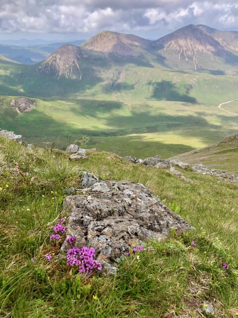
Belig (701m) is the eastern outlier of Skye's Red Cuillin, a steep gabbro-and-granite cone above Glen Sligachan in the NG54 square. Linked by sharp ridges to Garbh-bheinn and Glas Bheinn Mhor, it forms part of the airy traverse that ends at Sgurr nan Each. Looking west the Black Cuillin dominate; eastward the eye runs out over Loch Slapin to the Strathaird hills.
Quick facts
- Height
- 701.6m/ 2302ft
- Prominence
- 247 m
- Distance
- 13 km
- Ascent
- 575 m
- Time
- 4–6 hrs
- Grid ref
- NG543240
- Parking
- NG539237
- Nearest
- Fort William
- Dogs
- Dogs on lead required near livestockDog-friendly guide ↗
Height and prominence cross-checked against the Database of British and Irish Hills (CC BY).
No GPX track yet
Walked this route? Share your track to help other walkers.
Standard route
gabbro rock 50% · heather moorland 30% · grassy hollows 20%
From the lay-by at the head of Loch Slapin cross the burn and pick up the eroded stalkers' track climbing the steep south-east flank. The path zig-zags onto the south ridge at around 500m and a fine rocky crest leads directly to the cairn. Most parties continue west to Garbh-bheinn, returning by the bealach to Loch Ainort.
Terrain
Boggy lochside approach, then very steep slopes of loose granite scree and cropped turf. The summit ridge is rocky but the moves stay easy class 1. Loose footing on the descent is the main risk — the south-east face acts as a natural rubbish chute for cobbles loosed by walkers above.
In winter
Maritime Skye sees snow only intermittently but the steep south face holds neve into April in colder years. The narrow rocky ridge above the bealach becomes a Grade I winter route under hard snow. SAIS Skye and Lochalsh forecasts are essential reading once the Cuillin whiten.
Best time of year
Getting there
- Glasgow4h 39m
- Edinburgh4h 22m
OS maps: OS Landranger 32
Mobile signal: Poor. Remote Skye Red Cuillin; limited coverage from most networks.
Current conditions
Daylight Today
- Sunrise
- 04:47
- Sunset
- 22:13
- Civil dawn
- 03:45
- Civil dusk
- 23:15
NOAA Solar Calculator · 13 July 2026
Pair with
Curated multi-hill combinations from Belig.
Around Belig on the SCOT network
Getting there, basing yourself, and what to do off the hill.
Getting there: Kyle of Lochalsh station
Skye Bridge; Five Sisters of Kintail; Glen Shiel; Plockton
22km from the hill
tripscot.co.uk
On TripSCOTBase yourself in Portree
Main Skye base — Cuillin, Trotternish, Storr
21km from the hill
tripscot.co.uk
On TasteSCOTAfter the hill: Isle of Raasay Distillery
Raasay — new island distillery with rooms; Dun Caan walks from the door
13km from the hill
tastescot.co.uk
Belig — common questions
- How hard is Belig?
- We grade Belig at 4/5, which puts it in challenging territory. The usual route is around 13km with 575m of climbing; allow 4-6 hours. Underfoot: Boggy lochside approach, then very steep slopes of loose granite scree and cropped turf.
- What is Belig's prominence?
- 247m of prominence. That's the vertical drop from the summit to the col that links Belig to the next higher ground.
- Where do I park for Belig?
- Most walkers start from NG539237 near Fort William. Verify the grid reference on an OS map before you set off — space is tight on busy summer weekends.
- When is the best time to climb Belig?
- May, June, July, August, September give the most reliable conditions on Belig. Beyond that window the high ground turns wintry: carry full mountain kit, be confident navigating, and check the SAIS avalanche forecast for the area.
- Is Belig dog-friendly?
- Yes, but dogs must be kept on a lead — there is livestock or ground-nesting bird interest on the route.
- Is there mobile signal on Belig?
- Poor. Remote Skye Red Cuillin; limited coverage from most networks.
- Is Belig safe in winter?
- Maritime Skye sees snow only intermittently but the steep south face holds neve into April in colder years. The narrow rocky ridge above the bealach becomes a Grade I winter route under hard snow. SAIS Skye and Lochalsh forecasts are essential reading once the Cuillin whiten.
Get the OutdoorSCOT weekly
One email a week — new route, hill and bothy guides, seasonal conditions and the odd hard-won lesson. No spam, unsubscribe in one click.