Graham · Skye & The Small Isles
Beinn Dearg Mhor
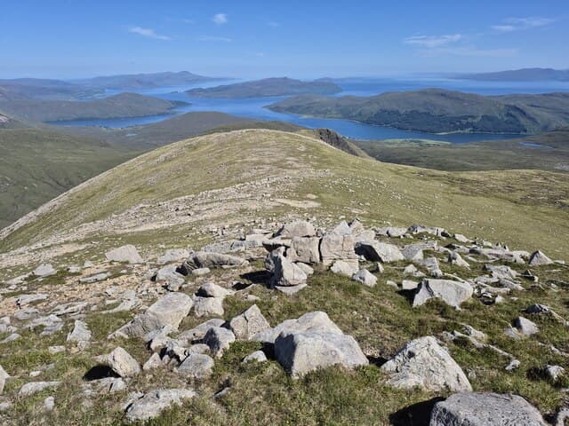
Beinn Dearg Mhor (709m) at NG58 is the highest of the Red Hills above the Strathaird peninsula on south Skye, a granite dome rising opposite the gabbro Black Cuillin across Loch Slapin. Its red weathered scree contrasts with the dark Cuillin rock visible across the loch. An inclined summit slab marks the highest point, with a remarkable view across Loch Scavaig to the Cuillin ridge and out to Rum, Eigg and Canna.
Gaelic: “mountain, red, big” · Pronunciation: bine jerr-ak vore
Quick facts
- Height
- 709.3m/ 2327ft
- Prominence
- 154 m
- Distance
- 13 km
- Ascent
- 581 m
- Time
- 4–6 hrs
- Grid ref
- NG587228
- Parking
- NG594231
- Nearest
- Fort William
- Dogs
- Dogs on lead required near livestockDog-friendly guide ↗
Height and prominence cross-checked against the Database of British and Irish Hills (CC BY).
No GPX track yet
Walked this route? Share your track to help other walkers.
Standard route
Torridonian sandstone 45% · heather moorland 35% · rocky summit 20%
From the Loch Slapin lay-by at NG594231, take the path along the burn before climbing the steep south-east shoulder. The upper section involves loose granite scree before easing onto the broad summit. 13km return, 581m climbed. Most parties combine with the neighbouring Beinn Dearg Bheag for a fuller red-hills day.
Terrain
The steep granite scree slopes are tedious on ascent and tiring on descent — small chips on a hard substrate move underfoot. The summit slab is solid rock for those last metres. Care needed on the south-east shoulder where rock bands break the line of ascent above 500m.
In winter
Red Hills granite holds verglas tenaciously after thaw-refreeze, more so than the Cuillin gabbro across the loch. Maritime systems queue up off the Outer Hebrides and drive low cloud across the Strathaird peninsula for days at a stretch. SAIS does not cover Skye directly; the mainland Lochaber bulletin is the closest indirect reference. December daylight is below seven hours here.
Best time of year
Getting there
- Glasgow4h 35m
- Edinburgh4h 18m
OS maps: OS Landranger 32
Mobile signal: Patchy on the Strathaird road — better signal returns higher on the south-east shoulder toward Broadford.
Current conditions
Daylight Today
- Sunrise
- 04:53
- Sunset
- 22:07
- Civil dawn
- 03:54
- Civil dusk
- 23:07
NOAA Solar Calculator · 17 July 2026
Pair with
Curated multi-hill combinations from Beinn Dearg Mhor.
Around Beinn Dearg Mhor on the SCOT network
Getting there, basing yourself, and what to do off the hill.
Getting there: Kyle of Lochalsh station
Skye Bridge; Five Sisters of Kintail; Glen Shiel; Plockton
18km from the hill
tripscot.co.uk
On TripSCOTBase yourself in Portree
Main Skye base — Cuillin, Trotternish, Storr
23km from the hill
tripscot.co.uk
On TasteSCOTAfter the hill: Isle of Raasay Distillery
Raasay — new island distillery with rooms; Dun Caan walks from the door
14km from the hill
tastescot.co.uk
Beinn Dearg Mhor — common questions
- How hard is Beinn Dearg Mhor?
- We grade Beinn Dearg Mhor at 4/5, which puts it in challenging territory. The usual route is around 13km with 581m of climbing; allow 4-6 hours. Terrain: The steep granite scree slopes are tedious on ascent and tiring on descent — small chips on a hard substrate move underfoot.
- How prominent is Beinn Dearg Mhor?
- Beinn Dearg Mhor has 154m of topographic prominence — the height of its summit above the highest col connecting it to higher ground.
- Where should I park to climb Beinn Dearg Mhor?
- Standard parking is at NG594231 near Fort William. Check the parking grid reference on an OS map before travel; informal laybys can fill on summer weekends.
- When should I climb Beinn Dearg Mhor?
- The standard good-weather months for Beinn Dearg Mhor are May, June, July, August, September. Outside those months, expect winter conditions on the high ground — full mountain kit, navigation skills, and a check of the SAIS avalanche forecast for the relevant region.
- Can I bring my dog up Beinn Dearg Mhor?
- On a lead only — the route crosses ground with livestock or nesting-bird interest.
- What's mobile reception like on Beinn Dearg Mhor?
- Patchy on the Strathaird road — better signal returns higher on the south-east shoulder toward Broadford.
- Is Beinn Dearg Mhor safe in winter?
- Red Hills granite holds verglas tenaciously after thaw-refreeze, more so than the Cuillin gabbro across the loch. Maritime systems queue up off the Outer Hebrides and drive low cloud across the Strathaird peninsula for days at a stretch. SAIS does not cover Skye directly; the mainland Lochaber bulletin is the closest indirect reference. December daylight is below seven hours here.
Get the OutdoorSCOT weekly
One email a week — new route, hill and bothy guides, seasonal conditions and the odd hard-won lesson. No spam, unsubscribe in one click.