Corbett · Skye & The Small Isles
Garbh-bheinn
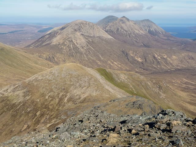
The Skye Garbh-bheinn is the easternmost of the Cuillin Hills proper — a rough gabbro peak that sits across Loch Slapin from Bla Bheinn but is geologically and visually a Black Cuillin outlier. At 808m the rocky summit gives an outstanding close-range view of the Cuillin ridge to the west and Bla Bheinn directly opposite. Like the rest of the Cuillin, the rock is rough magnetic gabbro that grips like sandpaper in dry conditions.
Gaelic: “rough” · Pronunciation: garrav bheinn
Quick facts
- Height
- 808.3m/ 2652ft
- Prominence
- 181 m
- Distance
- 15 km
- Ascent
- 711 m
- Time
- 5–8 hrs
- Grid ref
- NG531232
- Parking
- NG561217
- Nearest
- Fort William
- Dogs
- Dogs on lead required near livestockDog-friendly guide ↗
Height and prominence cross-checked against the Database of British and Irish Hills (CC BY).
No GPX track yet
Walked this route? Share your track to help other walkers.
Standard route
lochside path 20% · open heather 30% · gabbro blocks 40% · summit area 10%
Start from the small lay-by at the south end of Loch Slapin on the B8083 between Broadford and Elgol. Follow the path west toward Bla Bheinn for a short distance before peeling off north up the broad south-east shoulder of Garbh-bheinn. The route is pathless from the lower hill onward, climbing through heather and onto rough gabbro blocks. Around 15km return with 711m of ascent. Strong scramblers extend over to Bla Bheinn for a long day.
Terrain
Lower slopes are wet heather and bog with no path. The middle hillside transitions to firm gabbro blocks and short rocky steps. The upper hill is bare gabbro pavement with the summit cairn on a rocky promontory. Note that Cuillin gabbro distorts compass readings — magnetic anomaly affects navigation across much of this hill. Easy walking with brief hand-on-rock moves; no exposure on the standard line.
In winter
A serious winter Corbett — gabbro covered in verglas is treacherous, and the summit area becomes a proper mountaineering objective. The lower bog freezes into ice slick. Maritime conditions mean rapid swings; check the Cuillin forecast and the SAIS Skye report. The B8083 is generally clear.
Best time of year
Getting there
- Glasgow4h 39m
- Edinburgh4h 23m
OS maps: OS Landranger 32
Mobile signal: Intermittent at Loch Slapin; blank on the upper hill
Current conditions
Daylight Today
- Sunrise
- 04:47
- Sunset
- 22:13
- Civil dawn
- 03:45
- Civil dusk
- 23:15
NOAA Solar Calculator · 13 July 2026
Pair with
Curated multi-hill combinations from Garbh-bheinn.
Around Garbh-bheinn on the SCOT network
Getting there, basing yourself, and what to do off the hill.
Getting there: Kyle of Lochalsh station
Skye Bridge; Five Sisters of Kintail; Glen Shiel; Plockton
23km from the hill
tripscot.co.uk
On TripSCOTBase yourself in Portree
Main Skye base — Cuillin, Trotternish, Storr
21km from the hill
tripscot.co.uk
On TasteSCOTAfter the hill: Isle of Raasay Distillery
Raasay — new island distillery with rooms; Dun Caan walks from the door
13km from the hill
tastescot.co.uk
Garbh-bheinn — common questions
- How hard is Garbh-bheinn?
- We grade Garbh-bheinn at 3/5, which puts it in moderately challenging territory. The usual route is around 15km with 711m of climbing; allow 5-8 hours. Underfoot: Lower slopes are wet heather and bog with no path.
- What is Garbh-bheinn's prominence?
- 181m of prominence. That's the vertical drop from the summit to the col that links Garbh-bheinn to the next higher ground.
- Where do I park for Garbh-bheinn?
- Most walkers start from NG561217 near Fort William. Verify the grid reference on an OS map before you set off — space is tight on busy summer weekends.
- When is the best time to climb Garbh-bheinn?
- May, June, July, August, September give the most reliable conditions on Garbh-bheinn. Beyond that window the high ground turns wintry: carry full mountain kit, be confident navigating, and check the SAIS avalanche forecast for the area.
- Is Garbh-bheinn dog-friendly?
- Yes, but dogs must be kept on a lead — there is livestock or ground-nesting bird interest on the route.
- Is there mobile signal on Garbh-bheinn?
- Intermittent at Loch Slapin; blank on the upper hill
- Is Garbh-bheinn safe in winter?
- A serious winter Corbett — gabbro covered in verglas is treacherous, and the summit area becomes a proper mountaineering objective. The lower bog freezes into ice slick. Maritime conditions mean rapid swings; check the Cuillin forecast and the SAIS Skye report. The B8083 is generally clear.
Get the OutdoorSCOT weekly
One email a week — new route, hill and bothy guides, seasonal conditions and the odd hard-won lesson. No spam, unsubscribe in one click.