Graham · Skye & The Small Isles
The Storr
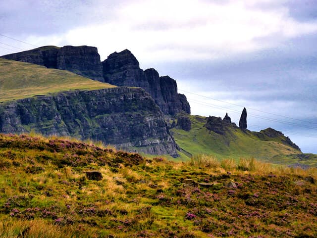
The Storr (718m) is the northern bastion of the Trotternish escarpment at NG45/49, a basalt mass whose eastern face has slumped to form the famed Sanctuary of pinnacles including the Old Man. Reached from the well-maintained Storr car park on the A855, the Graham summit lies on a grassy crown above the cliffs, looking south down the Trotternish ridge and east across the Sound of Raasay to the Applecross peaks. Few Scottish hills carry such an obvious geological signature — the lava-on-Jurassic-sediment landslip is textbook.
Quick facts
- Height
- 718.7m/ 2358ft
- Prominence
- 671 m
- Distance
- 13 km
- Ascent
- 589 m
- Time
- 4–6 hrs
- Grid ref
- NG495540
- Parking
- NG459450
- Nearest
- Ullapool
- Dogs
- Dogs on lead required near livestockDog-friendly guide ↗
Height and prominence cross-checked against the Database of British and Irish Hills (CC BY).
No GPX track yet
Walked this route? Share your track to help other walkers.
Standard route
forest path 20% · moorland path 30% · rocky slopes 35% · summit area 15%
From the rebuilt forest car park at NG459450, the engineered path climbs steadily through replanted woodland onto open hillside, with most visitors stopping at the Sanctuary viewpoint. Continue north-west onto Coire Faoin, then climb the steep grass shoulder onto the summit plateau above the cliff edge. Roughly 13km return, 589m ascent. Treat the Sanctuary as a passing detour, not the objective — the real summit is half an hour beyond.
Terrain
The Storr Lochs path is now an excellent flagged route as far as the pinnacles. Beyond, faint trods cross damp grass before a steep, eroded climb onto the rim. Keep well back from the edge in mist — the basalt cliff falls 200m sheer to the Sanctuary below. The summit itself is a wide grassy area marked by a low cairn.
In winter
Trotternish escarpments rarely build sustained alpine snow but eastern aspects can hold deep windslab through any northerly blast — the SAIS Northern Highlands area provides indirect guidance. Salt-laden gales drive horizontal sleet for days at a time. With under seven hours of useful December daylight at this latitude, even short Skye outings need a headtorch in a bag.
Best time of year
Getting there
- Glasgow4h 11m
- Edinburgh5h 50m
OS maps: OS Landranger 23
Mobile signal: Brief signal possible on Skye with Portree visible; 1 bar on the plateau
Current conditions
Daylight Today
- Sunrise
- 04:46
- Sunset
- 22:15
- Civil dawn
- 03:42
- Civil dusk
- 23:19
NOAA Solar Calculator · 13 July 2026
Pair with
Curated multi-hill combinations from The Storr.
On a long-distance route
The Storr sits within 5km of these named long-distance walks — useful for trail-pack rest days or section extensions.
Around The Storr on the SCOT network
Getting there, basing yourself, and what to do off the hill.
Getting there: Kyle of Lochalsh station
Skye Bridge; Five Sisters of Kintail; Glen Shiel; Plockton
38km from the hill
tripscot.co.uk
On TripSCOTBase yourself in Portree
Main Skye base — Cuillin, Trotternish, Storr
10km from the hill
tripscot.co.uk
On TasteSCOTAfter the hill: Isle of Raasay Distillery
Raasay — new island distillery with rooms; Dun Caan walks from the door
18km from the hill
tastescot.co.uk
The Storr — common questions
- What difficulty is The Storr?
- On the OutdoorSCOT scale, The Storr comes in at 4/5 — challenging. Expect roughly 13km and 589m of ascent on the usual route — 4-6 hours for most parties. Underfoot: The Storr Lochs path is now an excellent flagged route as far as the pinnacles.
- What is The Storr's prominence?
- 671m of prominence. That's the vertical drop from the summit to the col that links The Storr to the next higher ground.
- Where do I park for The Storr?
- Most walkers start from NG459450 near Ullapool. Verify the grid reference on an OS map before you set off — space is tight on busy summer weekends.
- When is the best time to climb The Storr?
- May, June, July, August, September give the most reliable conditions on The Storr. Beyond that window the high ground turns wintry: carry full mountain kit, be confident navigating, and check the SAIS avalanche forecast for the area.
- Is The Storr dog-friendly?
- Yes, but dogs must be kept on a lead — there is livestock or ground-nesting bird interest on the route.
- Is there mobile signal on The Storr?
- Brief signal possible on Skye with Portree visible; 1 bar on the plateau
- Is The Storr safe in winter?
- Trotternish escarpments rarely build sustained alpine snow but eastern aspects can hold deep windslab through any northerly blast — the SAIS Northern Highlands area provides indirect guidance. Salt-laden gales drive horizontal sleet for days at a time. With under seven hours of useful December daylight at this latitude, even short Skye outings need a headtorch in a bag.
Get the OutdoorSCOT weekly
One email a week — new route, hill and bothy guides, seasonal conditions and the odd hard-won lesson. No spam, unsubscribe in one click.