Munro · Glen Coe & Lochaber
Ben Nevis (Beinn Nibheis)
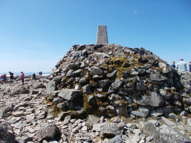
Ben Nevis — Beinn Nibheis, "the venomous mountain" — is the highest peak in the British Isles at 1344m, rising directly above Fort William and Loch Linnhe in Lochaber. The hill takes around 100,000 ascents a year, most up the well-built Mountain Track from Glen Nevis, but its north face hides one of the great alpine cliff faces in Europe: 600m of crag where ice climbers and mountaineers have written much of the history of British climbing. The summit is a wide stony plateau with the ruins of an old observatory and an emergency shelter on top of a triangulation pillar.
Quick facts
- Height
- 1344.53m/ 4411ft
- Prominence
- 1345 m
- Distance
- 21 km
- Ascent
- 1183 m
- Time
- 7–10 hrs
- Grid ref
- NN166712
- Parking
- NN123730
- Nearest city
- Fort William· 7km
- Dogs
- Dogs on lead required near livestockDog-friendly guide ↗
Height and prominence cross-checked against the Database of British and Irish Hills (CC BY).
No GPX track yet
Walked this route? Share your track to help other walkers.
Standard route
Good path 45% · Mountain path 30% · Plateau / boulder field 25%
The tourist route — the Mountain Track, sometimes still called the Pony Track — leaves the Glen Nevis visitor centre and climbs in long zig-zags up the western flank to the summit plateau. Total return is around 17km with 1352m of ascent (the figure of 21km in the database reflects a longer round). The path is unmissable, well-built and busy in summer. The classic alternative is the Càrn Mòr Dearg Arête, a Grade 1 scramble linking Ben Nevis to its eastern neighbour, accessed from the North Face car park near Torlundy.
Terrain
The Mountain Track is one of the best-built paths in the country — wide pitched stone for most of the route. The summit plateau is a maze of boulders dotted with snowfields into June, where the path disappears and navigation is by stone-marker. The compass deviates from true north here because of magnetic rock in the summit area — keep this in mind in mist. The north face cliffs are unfenced and the plateau edge is unforgiving.
In winter
In winter Ben Nevis is a serious mountaineering objective and the most common venue for cornice and avalanche-related accidents in Scotland. The summit plateau routinely picks up 4–6 metres of snow over a season; cornices form on every edge after westerly winds. Two specific bearings — 231° true to the head of the Red Burn for descent, then 282° true — are taught to every Scottish winter walker. Carry axe, crampons, map, compass, GPS and head-torch as standard.
This hill is in the Glen Coe SAIS forecast area. Check SAIS forecasts in winter (December–April).
Best time of year
Getting there
- Glasgow2h 26m
- Edinburgh3h 6m
OS maps: OS Landranger 41
Mobile signal: EE and Vodafone strongest at the Glen Nevis visitor centre car park. Signal drops out above 700m on the Mountain Track. No reliable signal on summit plateau. Download maps offline before you leave.
Current conditions
Daylight Today
- Sunrise
- 05:03
- Sunset
- 21:51
- Civil dawn
- 04:08
- Civil dusk
- 22:45
NOAA Solar Calculator · 23 July 2026
Pair with
Curated multi-hill combinations from Ben Nevis (Beinn Nibheis).
Around Ben Nevis (Beinn Nibheis) on the SCOT network
Getting there, basing yourself, and what to do off the hill.
Getting there: Fort William station
Ben Nevis, Mamores, Aonachs, Knoydart ferry connection
7km from the hill
tripscot.co.uk
On TripSCOTBase yourself in Fort William
Ben Nevis base, West Highland Line, gateway to Lochaber
7km from the hill
tripscot.co.uk
On TasteSCOTAfter the hill: Ben Nevis Distillery
Fort William — Lochaber distillery at the foot of the Ben; long-aged Japanese-owned classics
6km from the hill
tastescot.co.uk
Ben Nevis (Beinn Nibheis) — common questions
- Is Ben Nevis (Beinn Nibheis) a hard climb?
- Ben Nevis (Beinn Nibheis) is rated 4/5 (challenging) on the OutdoorSCOT scale. The standard route covers about 21km with 1183m of ascent and takes most walkers 7-10 hours. Terrain: The Mountain Track is one of the best-built paths in the country — wide pitched stone for most of the route.
- How prominent is Ben Nevis (Beinn Nibheis)?
- Ben Nevis (Beinn Nibheis)'s prominence is its full height — 1345m — because it is the highest point of its landmass, with no higher ground connected to it.
- Where should I park to climb Ben Nevis (Beinn Nibheis)?
- Standard parking is at NN123730. Check the parking grid reference on an OS map before travel; informal laybys can fill on summer weekends.
- When should I climb Ben Nevis (Beinn Nibheis)?
- The standard good-weather months for Ben Nevis (Beinn Nibheis) are May, June, July, August, September, October. Outside those months, expect winter conditions on the high ground — full mountain kit, navigation skills, and a check of the SAIS avalanche forecast for the relevant region.
- Can I bring my dog up Ben Nevis (Beinn Nibheis)?
- On a lead only — the route crosses ground with livestock or nesting-bird interest.
- What's mobile reception like on Ben Nevis (Beinn Nibheis)?
- EE and Vodafone strongest at the Glen Nevis visitor centre car park. Signal drops out above 700m on the Mountain Track. No reliable signal on summit plateau. Download maps offline before you leave.
- Is Ben Nevis (Beinn Nibheis) safe in winter?
- In winter Ben Nevis is a serious mountaineering objective and the most common venue for cornice and avalanche-related accidents in Scotland. The summit plateau routinely picks up 4–6 metres of snow over a season; cornices form on every edge after westerly winds. Two specific bearings — 231° true to the head of the Red Burn for descent, then 282° true — are taught to every Scottish winter walker. Carry axe, crampons, map, compass, GPS and head-torch as standard.
Get the OutdoorSCOT weekly
One email a week — new route, hill and bothy guides, seasonal conditions and the odd hard-won lesson. No spam, unsubscribe in one click.