Munro · Glen Coe & Lochaber
Aonach Beag
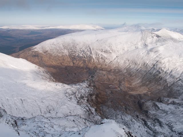
Aonach Beag — confusingly higher than its name-twin Aonach Mor — is the 1234m Munro east of Ben Nevis, the seventh highest hill in Britain. The pair sits across the deep Allt a' Mhuilinn glen from Ben Nevis, and the east face of the Aonachs is a major Scottish winter climbing venue with steep mixed routes that hold ice into late spring. The summit is a small cairn at the south end of a broad plateau, looking directly across to the north face of Ben Nevis — one of the great mountain views in the country.
Gaelic: “high ridge, small” · Pronunciation: oeun-ach bek
Quick facts
- Height
- 1234m/ 4049ft
- Prominence
- 404 m
- Distance
- 20 km
- Ascent
- 1086 m
- Time
- 6–10 hrs
- Grid ref
- NN197715
- Parking
- NN144764
- Nearest city
- Fort William· 9km
- Dogs
- Dogs on lead required near livestockDog-friendly guide ↗
Height and prominence cross-checked against the Database of British and Irish Hills (CC BY).
No GPX track yet
Walked this route? Share your track to help other walkers.
Standard route
Path to corrie 35% · Mountain path 35% · Summit plateau 30%
Most parties tackle Aonach Beag together with Aonach Mor via the Allt a' Mhuilinn approach from Torlundy near Fort William. Climb past the CIC Hut on Ben Nevis, then traverse east up onto the connecting ridge between the two Aonachs. Around 20km return with 1086m of ascent for the pair. Strong walkers extend across the CMD Arête to Ben Nevis itself for a major four-Munro day from the same start.
Terrain
The Allt a' Mhuilinn track is firm gravel as far as the CIC Hut. Above the hut the ground is steep grass and rock, opening to the broad twin plateaus of the two Aonachs. The summit ridge of Aonach Beag is narrow with significant drops east and west — pay attention near the cairn. The link to Aonach Mor is a wide grassy bealach.
In winter
The east face is a serious winter climbing venue (Grade III–VII routes). For walkers, the plateau between the two Aonachs is a navigation challenge in cloud and the south-east face above Steall has cornicing problems. The Allt a' Mhuilinn track is reliable in winter; conditions on top are alpine. SAIS Lochaber report applies.
This hill is in the Glen Coe SAIS forecast area. Check SAIS forecasts in winter (December–April).
Best time of year
Getting there
- Glasgow2h 24m
- Edinburgh3h 4m
OS maps: OS Landranger 41
Mobile signal: Reasonable EE signal at the Torlundy car park for the gondola. Signal fades above 800m on the north face approach. No reliable signal on summit.
Current conditions
Daylight Today
- Sunrise
- 05:02
- Sunset
- 21:50
- Civil dawn
- 04:07
- Civil dusk
- 22:45
NOAA Solar Calculator · 23 July 2026
Pair with
Curated multi-hill combinations from Aonach Beag.
Around Aonach Beag on the SCOT network
Getting there, basing yourself, and what to do off the hill.
Getting there: Fort William station
Ben Nevis, Mamores, Aonachs, Knoydart ferry connection
10km from the hill
tripscot.co.uk
On TripSCOTBase yourself in Fort William
Ben Nevis base, West Highland Line, gateway to Lochaber
9km from the hill
tripscot.co.uk
On TasteSCOTAfter the hill: Ben Nevis Distillery
Fort William — Lochaber distillery at the foot of the Ben; long-aged Japanese-owned classics
9km from the hill
tastescot.co.uk
Aonach Beag — common questions
- How difficult is Aonach Beag?
- Aonach Beag carries a 4/5 (challenging) grade on the OutdoorSCOT scale. Count on about 20km, 1086m of ascent and a 6-10 hour day on the standard route. Ground conditions: The Allt a' Mhuilinn track is firm gravel as far as the CIC Hut.
- How much drop does Aonach Beag have?
- The drop is 404m: measured from the summit of Aonach Beag down to the saddle joining it to higher terrain.
- Where's the parking for Aonach Beag?
- Park at NN144764. Double-check the grid reference on an OS map first; informal laybys here fill early in high season.
- What's the best month to climb Aonach Beag?
- Aim for May, June, July, August, September, October on Aonach Beag. In the remaining months treat it as a winter hill — full kit, solid navigation, and a look at the relevant SAIS avalanche forecast before you go.
- Can dogs go up Aonach Beag?
- Dogs are fine on a lead. The route passes livestock or ground-nesting bird habitat, so keep them close throughout.
- Will I get phone signal on Aonach Beag?
- Reasonable EE signal at the Torlundy car park for the gondola. Signal fades above 800m on the north face approach. No reliable signal on summit.
- Is Aonach Beag safe in winter?
- The east face is a serious winter climbing venue (Grade III–VII routes). For walkers, the plateau between the two Aonachs is a navigation challenge in cloud and the south-east face above Steall has cornicing problems. The Allt a' Mhuilinn track is reliable in winter; conditions on top are alpine. SAIS Lochaber report applies.
Get the OutdoorSCOT weekly
One email a week — new route, hill and bothy guides, seasonal conditions and the odd hard-won lesson. No spam, unsubscribe in one click.