Munro · Glen Coe & Lochaber
Sgurr Choinnich Mor
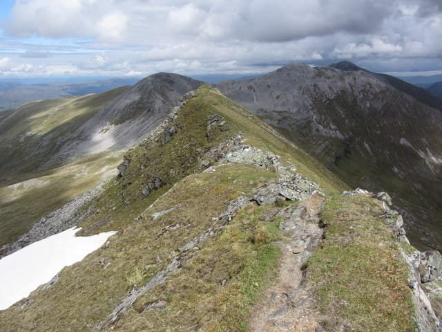
Sgurr Choinnich Mor — "big mossy peak" — is the 1094m Munro at the western end of the Grey Corries ridge, the most dramatic summit of the range with a near-perfect pyramid profile when seen from the Aonachs. The summit cairn sits on a narrow rocky crest above steep slopes falling north into the upper Allt Coire Easain. Often climbed at the far end of a Grey Corries traverse, or paired with Aonach Beag via the connecting high col.
Gaelic: “sharp peak, big” · Pronunciation: skoor choinnich more
Quick facts
- Height
- 1094m/ 3589ft
- Prominence
- 159 m
- Distance
- 18 km
- Ascent
- 963 m
- Time
- 6–9 hrs
- Grid ref
- NN227714
- Parking
- NN255810
- Nearest city
- Fort William· 12km
- Dogs
- Dogs on lead required near livestockDog-friendly guide ↗
Height and prominence cross-checked against the Database of British and Irish Hills (CC BY).
No GPX track yet
Walked this route? Share your track to help other walkers.
Standard route
Corriechoille forest track 25% · Open hillside 30% · Quartzite ridge 45%
Most parties reach Sgurr Choinnich Mor via the Grey Corries ridge from Corriechoille — a long high-level traverse from Stob Choire Claurigh in the east. Alternatively, the hill can be approached more directly from Corrour Station via the Lairig Leacach to the south. Around 18km return with 963m of ascent for the single summit; the full Grey Corries round is 22km with 1700m of climb.
Terrain
The Lairig Leacach approach track is firm gravel. The Grey Corries ridge crest is pale broken quartzite — superb walking in dry conditions, slippery in wet. The summit cone of Sgurr Choinnich Mor itself is narrow and exposed on its northern flank; the east ridge approach has a short steeper section near the top.
In winter
A serious winter day on exposed quartzite ridges. Cornicing on the north sides of the Grey Corries summits is consistent. Avalanche risk on the north corries after westerly storms. The Sgurr Choinnich Mor cone in winter is a Grade I scramble at minimum. SAIS Lochaber applies.
This hill is in the Glen Coe SAIS forecast area. Check SAIS forecasts in winter (December–April).
Best time of year
Getting there
- Glasgow2h 23m
- Edinburgh3h 1m
OS maps: OS Landranger 41
Mobile signal: Dead above 800m on the Grey Corries. Spean Bridge has 4G. Fetch maps before heading into the Grey Corries from Corriechoille.
Current conditions
Daylight Today
- Sunrise
- 05:02
- Sunset
- 21:50
- Civil dawn
- 04:07
- Civil dusk
- 22:45
NOAA Solar Calculator · 23 July 2026
Pair with
Curated multi-hill combinations from Sgurr Choinnich Mor.
Around Sgurr Choinnich Mor on the SCOT network
Getting there, basing yourself, and what to do off the hill.
Getting there: Roy Bridge station
Glen Roy; Grey Corries (Stob Choire Claurigh, Sgurr Choinnich Mor)
11km from the hill
tripscot.co.uk
On TripSCOTBase yourself in Fort William
Ben Nevis base, West Highland Line, gateway to Lochaber
12km from the hill
tripscot.co.uk
On TasteSCOTAfter the hill: Ben Nevis Distillery
Fort William — Lochaber distillery at the foot of the Ben; long-aged Japanese-owned classics
12km from the hill
tastescot.co.uk
Sgurr Choinnich Mor — common questions
- What difficulty is Sgurr Choinnich Mor?
- On the OutdoorSCOT scale, Sgurr Choinnich Mor comes in at 4/5 — challenging. Expect roughly 18km and 963m of ascent on the usual route — 6-9 hours for most parties. Underfoot: The Lairig Leacach approach track is firm gravel.
- What is Sgurr Choinnich Mor's prominence?
- 159m of prominence. That's the vertical drop from the summit to the col that links Sgurr Choinnich Mor to the next higher ground.
- Where do I park for Sgurr Choinnich Mor?
- Most walkers start from NN255810. Verify the grid reference on an OS map before you set off — space is tight on busy summer weekends.
- When is the best time to climb Sgurr Choinnich Mor?
- May, June, July, August, September, October give the most reliable conditions on Sgurr Choinnich Mor. Beyond that window the high ground turns wintry: carry full mountain kit, be confident navigating, and check the SAIS avalanche forecast for the area.
- Is Sgurr Choinnich Mor dog-friendly?
- Yes, but dogs must be kept on a lead — there is livestock or ground-nesting bird interest on the route.
- Is there mobile signal on Sgurr Choinnich Mor?
- Dead above 800m on the Grey Corries. Spean Bridge has 4G. Fetch maps before heading into the Grey Corries from Corriechoille.
- Is Sgurr Choinnich Mor safe in winter?
- A serious winter day on exposed quartzite ridges. Cornicing on the north sides of the Grey Corries summits is consistent. Avalanche risk on the north corries after westerly storms. The Sgurr Choinnich Mor cone in winter is a Grade I scramble at minimum. SAIS Lochaber applies.
Get the OutdoorSCOT weekly
One email a week — new route, hill and bothy guides, seasonal conditions and the odd hard-won lesson. No spam, unsubscribe in one click.