Region
Galloway & the Southern Uplands
Dark skies, the 7stanes, and Scotland's least-midged hills — closer than you think.
- Corbetts
- 7
- Grahams
- 22
- Donalds
- 82
- Bothies
- 10
- Trail centres
- 11
- Long-distance trails
- 15
- Wild swimming
- 6
- Gravel routes
- 4
- Dark sky sites
- 2
- Highest peak
- Merrick (843m)
Galloway and the Southern Uplands are the quiet end of Scottish hillwalking. The Merrick (843m) is the highest point in southern Scotland and the centrepiece of the Galloway Hills — a compact group of rounded granite summits above Loch Trool that includes the best hill walking south of the Highland Boundary Fault. The terrain is heathery, boggy in places, and genuinely enjoyable in a way that doesn't depend on superlatives. On a clear winter day, the views from the Merrick south over the Solway Firth to the Lake District and north to the Arran skyline are exceptional.
The 7stanes mountain bike trail network — Glentress, Mabie, Kirroughtree, Glentrool, Ae, Dalbeattie, and Innerleithen — has put Galloway on the map for cyclists and given the region a tourism infrastructure that wouldn't otherwise exist. Glentress near Peebles is the flagship site and one of the finest trail centres in Britain. Kirroughtree near Newton Stewart is the Galloway Hills specialist, with trails that work through open moorland as well as forest. The 7stanes as a whole are the reason there are decent cafes and bike shops in small Dumfries and Galloway towns.
The Galloway Forest Park Dark Sky Park is the largest in the UK. The area has some of the lowest light-pollution levels in Scotland, and on a clear winter night the Milky Way is visible to the naked eye. The observatory at Kielder is technically just over the border in England, but the Galloway Dark Sky Park Visitor Centre at Clatteringshaws Loch is the Scottish base for stargazing events. Winter visits for dark-sky watching, combined with the surprising mildness of the Solway coast, make Galloway a genuinely compelling shoulder-season destination. See our guide to seeing the Northern Lights in Scotland for aurora forecasting, the Kp index and the country's best dark-sky viewing sites.
Glens1 glen guide
All glens →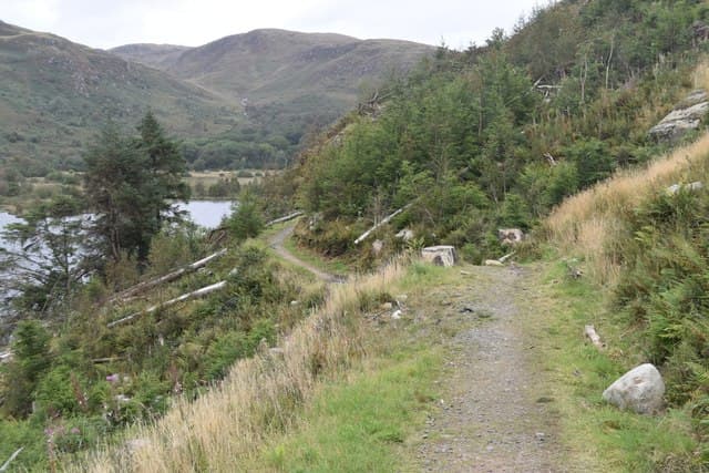
Hills · 7 Corbetts · 22 Grahams · 82 Donalds
Long-distance trails
West Highland Way
Southern Upland Way
Rob Roy Way
John Muir Way
Fife Coastal Path
Arran Coastal Way
St Cuthberts Way
Borders Abbeys Way
Loch Lomond and Cowal Way
Clyde Walkway
Ayrshire Coastal Path
Cross Borders Drove Road
River Ayr Way
Berwickshire Coastal Path
West Island Way
Bothies10 in this region
Mountain biking
Glentress
Glentress Peel, Peebles
Innerleithen
Traquair Road, Innerleithen
Kirroughtree
Kirroughtree Forest, Newton Stewart
Ae Forest
Ae Village, Parkgate, Dumfries
Mabie Forest
Mabie, Dumfries
Dalbeattie
Richorn, Dalbeattie
Newcastleton (Newcastleton Forest)
Dykecrofts, Newcastleton
Beecraigs Country Park
Beecraigs Country Park, Linlithgow
Glentrool
Glentrool Visitor Centre, Bargrennan, Newton Stewart
Craik Forest
Craik Forest, near Hawick
The Golfie (Innerleithen Naturals)
Minch Moor / Innerleithen
Wild swimming6 spots
Gravel cycling4 routes
Wild camping
Dark sky & northern lights2 sites
Map
Hills (dark/mid green), bothies (brown), wild swimming (blue), dark sky (purple).
Getting there
Dumfries
45 min drive
Glasgow
1.5 hr drive
Edinburgh
2 hr drive
Carlisle
1 hr drive
Guided support for Galloway & the Southern Uplands
If you'd prefer a guided experience, these operators run trips in this area.
Wilderness Scotland
Premium guided expeditions, all regions
Macs Adventure
Self-guided LDP specialists
Hillwalk Tours
Self-guided routes, luggage transfer
Absolute Escapes
Edinburgh-based independent operator
Affiliate links — disclosure
Our take
The Southern Upland Way's Galloway section — from Portpatrick to St John's Town of Dalry — is the best part of the route and the least-walked. The Galloway Hills section above the Ken Water is genuinely remote, with no roads and no facilities for 35 kilometres. It's the part of the walk that separates walkers from tourists, and it's the part most worth doing. If you can't commit to the full route, walk the Galloway section as a standalone — three or four days from Portpatrick to Sanquhar, using the bothy at White Laggan for one night.
The midges in Galloway are significantly better than the Highlands — not absent, but manageable most of the time. This makes June and early July more pleasant here than in Torridon or Knoydart. Combined with the longer season (March to November is realistic for most walks), Galloway genuinely punches above its weight for accessible mountain days with fewer of the environmental frustrations that make summer Highland trips miserable.
Track your Galloway & the Southern Uplands hills
Log your completions across the Galloway & the Southern Uplands hills and plan your next route.
Open Hill Tracker →Explore nearby regions
Scotland outdoor updates
Route guides, condition reports and seasonal picks — once a week, no noise.
Around Galloway & the Southern Uplands on the SCOT network
Sister sites covering food, drink and travel context for the same area. Linked direct.
Lowland whisky region
21 distilleries — Scotland's lightest, most delicate whiskies and its most underrated region.
tastescot.co.uk
On TripSCOTKirkcudbright
Galloway base — Solway coast, Galloway Forest, Mull of Galloway Trail
tripscot.co.uk
On TripSCOTBrodick
Arran base — Goat Fell, Glen Rosa, the Arran ridge
tripscot.co.uk