Corbett · Galloway
Corserine
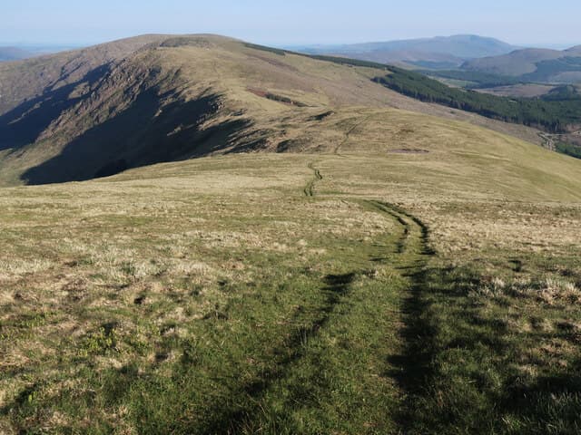
Corserine is the high point of the Rhinns of Kells — the long ridge running south from the Awful Hand range to form the eastern wall of the Galloway hills. At 814m it is the highest summit on the Southern Uplands' eastern flank and gives a long ridge walk with views across the Glenkens to Ayrshire on one side and east to the Lowther hills on the other. Less visited than nearby Merrick, the hill rewards a quieter day in the same Galloway granite landscape: small lochans, white granite tors, and an immense sense of empty space.
Quick facts
- Height
- 814m/ 2671ft
- Prominence
- 488 m
- Distance
- 18 km
- Ascent
- 830 m
- Time
- 4–7 hrs
- Grid ref
- NX497870
- Parking
- NX553864
- Nearest
- Glasgow· Dumfries 49km
- Dogs
- Dogs on lead required near livestockDog-friendly guide ↗
Height and prominence cross-checked against the Database of British and Irish Hills (CC BY).
No GPX track yet
Walked this route? Share your track to help other walkers.
Standard route
forest track 20% · moorland path 35% · grassy ridge 35% · summit area 10%
The usual route starts from Forrest Lodge car park in Glen Trool Forest Park. Follow the forestry tracks east then north onto the open hillside, climbing onto Meaul (814m) before continuing north along the Rhinns of Kells ridge to Corserine. Strong walkers extend by traversing the whole Rhinns including Carlin's Cairn and Cairn Hill, descending back via Lairdmannoch or returning the same way. Allow 6–7 hours for the standard there-and-back ridge.
Terrain
Forestry track for the first 3km — fast going. Above the trees the route is a broad grassy ridge with peat hags in places, occasionally muddy underfoot. The summit area is a flat grassy plateau with a trig pillar; the ridge connecting the Rhinns has several subsidiary tops that can be confusing in cloud.
In winter
Corserine in firm winter conditions is a long ridge walk with easily the best winter panoramas in southern Scotland. Snow cover is intermittent — typically lying for stretches of January and February. The exposure on the open ridge is significant; east winds across the Solway can be ferocious. The forestry approach holds ice readily.
Best time of year
Getting there
- Glasgow2h 53m
- Edinburgh2h 27m
OS maps: OS Landranger 77
Mobile signal: Good signal in Galloway; 2-3 bars at the top
Current conditions
Daylight Today
- Sunrise
- 04:55
- Sunset
- 21:52
- Civil dawn
- 04:01
- Civil dusk
- 22:46
NOAA Solar Calculator · 13 July 2026
Pair with
Curated multi-hill combinations from Corserine.
Around Corserine on the SCOT network
Getting there, basing yourself, and what to do off the hill.
Corserine — common questions
- What difficulty is Corserine?
- On the OutdoorSCOT scale, Corserine comes in at 2/5 — moderate. Expect roughly 18km and 830m of ascent on the usual route — 4-7 hours for most parties. Ground conditions: Forestry track for the first 3km — fast going.
- How much drop does Corserine have?
- The drop is 488m: measured from the summit of Corserine down to the saddle joining it to higher terrain.
- Where's the parking for Corserine?
- Park at NX553864 near Glasgow. Double-check the grid reference on an OS map first; informal laybys here fill early in high season.
- What's the best month to climb Corserine?
- Aim for April, May, June, July, August, September, October on Corserine. In the remaining months treat it as a winter hill — full kit, solid navigation, and a look at the relevant SAIS avalanche forecast before you go.
- Can dogs go up Corserine?
- Dogs are fine on a lead. The route passes livestock or ground-nesting bird habitat, so keep them close throughout.
- Will I get phone signal on Corserine?
- Good signal in Galloway; 2-3 bars at the top
- Is Corserine safe in winter?
- Corserine in firm winter conditions is a long ridge walk with easily the best winter panoramas in southern Scotland. Snow cover is intermittent — typically lying for stretches of January and February. The exposure on the open ridge is significant; east winds across the Solway can be ferocious. The forestry approach holds ice readily.
Get the OutdoorSCOT weekly
One email a week — new route, hill and bothy guides, seasonal conditions and the odd hard-won lesson. No spam, unsubscribe in one click.