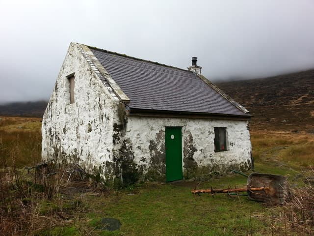
Bothy
Tunskeen
A small bothy in the heart of the Galloway Forest, below the Range of the Awful Hand (grid ref NX 425 906). Owned by Galloway Forest and maintained by the MBA, with a multi-fuel stove.
Quick facts
- Walk-in
- Not published
- Sleeps
- Not published
- Altitude
- 310m
- Condition
- Good condition
- Grid ref
- NX425906
- Maintained by
- Mountain Bothies Association
- Fire / stove
- Stove
- Water
- Tunskeen Burn runs close to the bothy — clean, reliable upland moorland burn in all but extreme drought.
- Mobile signal
- No mobile signal. One of the most remote locations in southern Scotland; the Galloway Forest Dark Sky Park status reflects the near-total absence of infrastructure.
- Dogs
- Dogs welcome off-lead
Our take
Tunskeen is the base for the Merrick and the Dungeon Hills, the roughest ground in southern Scotland. Plan the approach on the map, carry fuel, and take your rubbish out.
Getting there
Tunskeen is reached by forest roads and rough ground; walkers’ reports describe approaches from the north via the forest roads off the Stinchar Bridge road. The MBA does not publish a route or walk-in distance — plan it on the OS map before you go. Burns on the way can be high after rain.
Nearest parking: Forest-road car parks on the edge of the Galloway Forest Park — the MBA does not name one
No approach GPX yet
Walked this approach? Share your track to help other bothy-goers.
Stalking season / estate access
Owned by Galloway Forest (MBA). Check for forestry operations or deer control notices before you go.
What to expect inside
A small MBA bothy with a multi-fuel stove. There is no rubbish collection at any bothy — take all your litter home (MBA).
Nearby hills
Multi-bothy trips
The defining Galloway bothy-to-bothy traverse across the Dungeon Hills. Largely pathless and demanding — a full mountain day with no marked paths between the two.
When to visit
Best April–October. The Galloway Hills have their own microclimate — wetter than the Borders but milder than the Highlands. The Merrick is walkable year-round with care.
Wildfire risk — May to October
Dry conditions increase wildfire risk during summer. Never light fires in the open. Use the bothy fireplace only, and ensure it is fully out before you leave.
Current conditions
Condition unverified
We have not received a recent visitor report for this bothy. Check the MBA bothy register for current status before relying on this bothy as shelter.
Daylight Today
- Sunrise
- 07:13
- Sunset
- 16:50
- Civil dawn
- 06:35
- Civil dusk
- 17:28
NOAA Solar Calculator · 28 October 2026
Share your experience
Stayed at Tunskeen? Help other walkers plan their visit.
Stock up at Kirkcudbright
Nearest TripSCOT town for food, fuel, and accommodation if the bothy is busy.
Tunskeen — common questions
- How far is the walk into Tunskeen?
- We have not found a published walk-in distance for Tunskeen. Tunskeen is reached by forest roads and rough ground; walkers’ reports describe approaches from the north via the forest roads off the Stinchar Bridge road.
- Is there a fire at Tunskeen?
- Yes — Tunskeen has a stove. Carry your own fuel in: dead wood is scarce around most Scottish bothies, and burning bothy furniture or fence posts is never acceptable.
- How many people does Tunskeen sleep?
- The operator publishes no bed count for Tunskeen. Bothies are first-come-first-served and you may share with strangers, so carry a tent as a backup.
- Is there water at Tunskeen?
- Tunskeen Burn runs close to the bothy — clean, reliable upland moorland burn in all but extreme drought.
- When can I visit Tunskeen?
- Best months: April, May, June, July, August, September, October. Owned by Galloway Forest (MBA). Check for forestry operations or deer control notices before you go.
Bag more bothies
One email a week — new bothy and hill guides, seasonal conditions and the odd hard-won lesson. No spam, unsubscribe in one click.