Donald · Galloway
Tarfessock
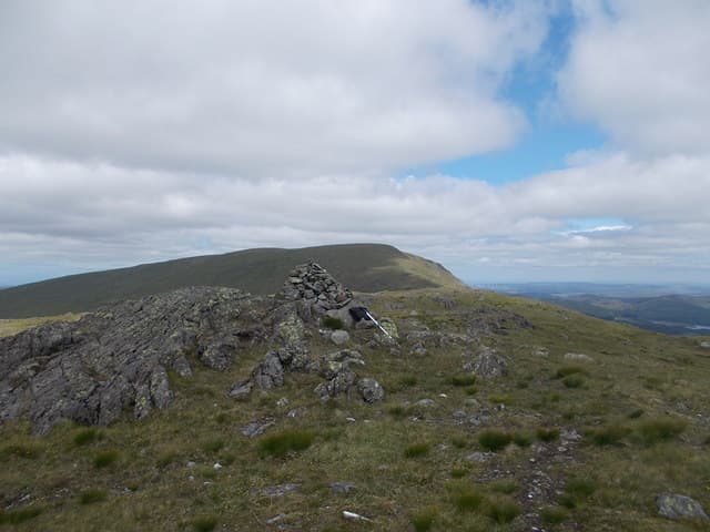
Tarfessock is the middle finger of the Awful Hand, set between Shalloch on Minnoch to the north and Kirriereoch to the south. A neat cairn sits on a small granite outcrop at the top, with the immense glacial bowl of Loch Macaterick spread out to the east.
Quick facts
- Height
- 696.4m/ 2285ft
- Prominence
- 69 m
- Distance
- 13 km
- Ascent
- 571 m
- Time
- 3–6 hrs
- Grid ref
- NX409891
- Parking
- NX409898
- Nearest city
- Dumfries· 58km
- Dogs
- Dogs on lead required near livestockDog-friendly guide ↗
Height and prominence cross-checked against the Database of British and Irish Hills (CC BY).
No GPX track yet
Walked this route? Share your track to help other walkers.
Standard route
heather moorland 60% · grass moorland 25% · rocky summit 15%
Take the forest road from the Stinchar Bridge near Cornish Loch and break off onto Pilot Knowe, joining the Awful Hand ridge for the walk south. Most parties continue to Shalloch on Minnoch or Kirriereoch to make the day worthwhile.
Terrain
Long forest road approach, then heather and bog before short heath on the ridge. Two minor summits flank the Donald top; the cairned outcrop is the southern one.
In winter
Wet rather than snowy in most south-westerly weather; the granite outcrop turns to a slick rink in freeze-thaw. The eastern lip above Loch Macaterick can hold modest cornices in north winds.
Best time of year
Getting there
- Glasgow2h 52m
- Edinburgh3h 33m
OS maps: OS Landranger 77
Mobile signal: Patchy. EE sporadic up top; coverage limited in the Stinchar area.
Current conditions
Daylight Today
- Sunrise
- 04:55
- Sunset
- 21:52
- Civil dawn
- 04:01
- Civil dusk
- 22:46
NOAA Solar Calculator · 13 July 2026
Pair with
Curated multi-hill combinations from Tarfessock.
Around Tarfessock on the SCOT network
Getting there, basing yourself, and what to do off the hill.
Tarfessock — common questions
- Is Tarfessock a hard climb?
- Tarfessock is rated 3/5 (moderately challenging) on the OutdoorSCOT scale. The standard route covers about 13km with 571m of ascent and takes most walkers 3-6 hours. Underfoot: Long forest road approach, then heather and bog before short heath on the ridge.
- What is Tarfessock's prominence?
- 69m of prominence. That's the vertical drop from the summit to the col that links Tarfessock to the next higher ground.
- Where do I park for Tarfessock?
- Most walkers start from NX409898. Verify the grid reference on an OS map before you set off — space is tight on busy summer weekends.
- When is the best time to climb Tarfessock?
- March, April, May, June, July, August, September, October, November give the most reliable conditions on Tarfessock. Beyond that window the high ground turns wintry: carry full mountain kit, be confident navigating, and check the SAIS avalanche forecast for the area.
- Is Tarfessock dog-friendly?
- Yes, but dogs must be kept on a lead — there is livestock or ground-nesting bird interest on the route.
- Is there mobile signal on Tarfessock?
- Patchy. EE sporadic up top; coverage limited in the Stinchar area.
- Is Tarfessock safe in winter?
- Wet rather than snowy in most south-westerly weather; the granite outcrop turns to a slick rink in freeze-thaw. The eastern lip above Loch Macaterick can hold modest cornices in north winds.
Get the OutdoorSCOT weekly
One email a week — new route, hill and bothy guides, seasonal conditions and the odd hard-won lesson. No spam, unsubscribe in one click.