Corbett · North-West Highlands
Quinag — Sail Gharbh
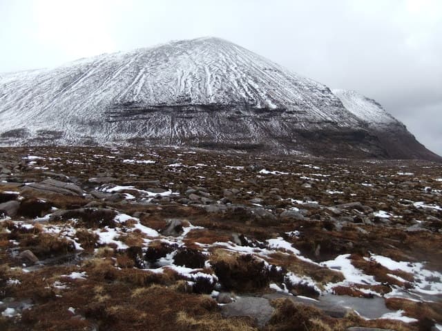
Sail Gharbh — 'the rough heel' — is the highest of Quinag's three Corbett summits at 808m, sitting at the eastern end of the Y-shaped massif rising above Loch Assynt. Where Spidean Coinich anchors the southern apex of Quinag and Sail Ghorm caps the northern arm, Sail Gharbh terminates the eastern leg, looking out over the broad sweep of moorland toward Lochinver. The summit is reached by an excellent John Muir Trust path and the full Quinag traverse including all three tops is one of the iconic Sutherland ridge days.
Gaelic: “rough” · Pronunciation: quinag sail yarrav
Quick facts
- Height
- 809m/ 2654ft
- Prominence
- 550 m
- Distance
- 12 km
- Ascent
- 800 m
- Time
- 3–6 hrs
- Grid ref
- NC209293
- Parking
- NC233274
- Nearest
- Ullapool· Inverness 95km
- Dogs
- Dogs on lead required near livestockDog-friendly guide ↗
Height and prominence cross-checked against the Database of British and Irish Hills (CC BY).
No GPX track yet
Walked this route? Share your track to help other walkers.
Standard route
bog path 20% · sandstone path 40% · rocky plateau 30% · summit rocks 10%
The starting point is the JMT layby on the A894 at NC233274 — the shared trailhead for all three Quinag Corbetts. From the layby, follow the rebuilt pitched-stone path west and gain the central bealach of the massif. From the bealach, the eastern arm leads north-east across broad rocky ground to the summit of Sail Gharbh. Sail Gharbh on its own takes 4–5 hours; the full Quinag traverse is 7–8.
Terrain
Excellent pitched-stone path runs from the JMT car park to the central bealach — a rebuild that has saved the underlying ground from erosion damage. Above the bealach the ridge opens into broad Torridonian sandstone slab with occasional rocky steps. The summit area is a small rocky platform with a cairn; the eastern face plunges into Coire na Maoile. In cloud, the rim needs respect.
In winter
Sail Gharbh under snow is a serious day. The pitched path holds verglas late; cornices form on the rim of Coire na Maoile to the north-east. The full Quinag traverse in firm winter conditions is one of the great small-mountain ridge expeditions in Britain, but it demands real winter mountaineering judgement — short midwinter daylight at this latitude and no phone signal on the ridge compound the commitment.
This hill is in the Torridon SAIS forecast area. Check SAIS forecasts in winter (December–April).
Best time of year
Getting there
- Glasgow5h 5m
- Edinburgh5h 10m
OS maps: OS Explorer 442
Mobile signal: No coverage on approach or top — Sutherland's interior is a communications blackout zone
Current conditions
Daylight Today
- Sunrise
- 04:36
- Sunset
- 22:16
- Civil dawn
- 03:28
- Civil dusk
- 23:24
NOAA Solar Calculator · 13 July 2026
Pair with
Curated multi-hill combinations from Quinag — Sail Gharbh.
On a long-distance route
Quinag — Sail Gharbh sits within 5km of these named long-distance walks — useful for trail-pack rest days or section extensions.
Around Quinag — Sail Gharbh on the SCOT network
Getting there, basing yourself, and what to do off the hill.
Quinag — Sail Gharbh — common questions
- What difficulty is Quinag — Sail Gharbh?
- On the OutdoorSCOT scale, Quinag — Sail Gharbh comes in at 3/5 — moderately challenging. Expect roughly 12km and 800m of ascent on the usual route — 3-6 hours for most parties. Terrain: Excellent pitched-stone path runs from the JMT car park to the central bealach — a rebuild that has saved the underlying ground from erosion damage.
- How prominent is Quinag — Sail Gharbh?
- Quinag — Sail Gharbh has 550m of topographic prominence — the height of its summit above the highest col connecting it to higher ground.
- Where should I park to climb Quinag — Sail Gharbh?
- Standard parking is at NC233274 near Ullapool. Check the parking grid reference on an OS map before travel; informal laybys can fill on summer weekends.
- When should I climb Quinag — Sail Gharbh?
- The standard good-weather months for Quinag — Sail Gharbh are May, June, September, October. Outside those months, expect winter conditions on the high ground — full mountain kit, navigation skills, and a check of the SAIS avalanche forecast for the relevant region.
- Can I bring my dog up Quinag — Sail Gharbh?
- On a lead only — the route crosses ground with livestock or nesting-bird interest.
- What's mobile reception like on Quinag — Sail Gharbh?
- No coverage on approach or top — Sutherland's interior is a communications blackout zone
- Is Quinag — Sail Gharbh safe in winter?
- Sail Gharbh under snow is a serious day. The pitched path holds verglas late; cornices form on the rim of Coire na Maoile to the north-east. The full Quinag traverse in firm winter conditions is one of the great small-mountain ridge expeditions in Britain, but it demands real winter mountaineering judgement — short midwinter daylight at this latitude and no phone signal on the ridge compound the commitment.
Get the OutdoorSCOT weekly
One email a week — new route, hill and bothy guides, seasonal conditions and the odd hard-won lesson. No spam, unsubscribe in one click.