Graham · Far North
Meallan a' Chuail
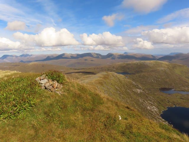
A small Lewisian gneiss summit rising above Loch Glendhu in west Sutherland, paired closely with the Corbett Beinn Leoid to the north-east. The whole area is a chaos of bare bedrock knolls and tiny lochans giving views deep into the Reay Forest.
Quick facts
- Height
- 750.5m/ 2462ft
- Prominence
- 205 m
- Distance
- 14 km
- Ascent
- 615 m
- Time
- 4–7 hrs
- Grid ref
- NC344292
- Parking
- NC393320
- Nearest
- Ullapool· Inverness 90km
- Dogs
- Dogs on lead required near livestockDog-friendly guide ↗
Height and prominence cross-checked against the Database of British and Irish Hills (CC BY).
No GPX track yet
Walked this route? Share your track to help other walkers.
Standard route
coast path 20% · deep heather 45% · grassy upper slopes 25% · summit area 10%
Start at Loch Merkland on the A838 and follow the stalkers' path west through the woodland to Loch an Leothaid. From there, rough trackless ground south-west leads up the heathery flank to the rocky little top.
Terrain
Excellent stalkers' path on the approach, then knobbly trackless gneiss requiring constant route-choice between outcrops. Wet hollows and small lochans break up the line.
In winter
A short hill but the surrounding terrain becomes a navigation puzzle in snow as the small lochans and outcrops merge into one white surface. Sub-zero days bring rime to the gneiss; eye to weather windows is essential at this latitude.
Best time of year
Getting there
- Glasgow5h 5m
- Edinburgh5h 12m
OS maps: OS Landranger 15
Mobile signal: Nothing in this remote Loch Morar/Knoydart area
Current conditions
Daylight Today
- Sunrise
- 04:41
- Sunset
- 22:10
- Civil dawn
- 03:37
- Civil dusk
- 23:14
NOAA Solar Calculator · 17 July 2026
Around Meallan a' Chuail on the SCOT network
Getting there, basing yourself, and what to do off the hill.
Meallan a' Chuail — common questions
- Is Meallan a' Chuail a hard climb?
- Meallan a' Chuail is rated 4/5 (challenging) on the OutdoorSCOT scale. The standard route covers about 14km with 615m of ascent and takes most walkers 4-7 hours. Ground conditions: Excellent stalkers' path on the approach, then knobbly trackless gneiss requiring constant route-choice between outcrops.
- How much drop does Meallan a' Chuail have?
- The drop is 205m: measured from the summit of Meallan a' Chuail down to the saddle joining it to higher terrain.
- Where's the parking for Meallan a' Chuail?
- Park at NC393320 near Ullapool. Double-check the grid reference on an OS map first; informal laybys here fill early in high season.
- What's the best month to climb Meallan a' Chuail?
- Aim for May, June, July, August, September on Meallan a' Chuail. In the remaining months treat it as a winter hill — full kit, solid navigation, and a look at the relevant SAIS avalanche forecast before you go.
- Can dogs go up Meallan a' Chuail?
- Dogs are fine on a lead. The route passes livestock or ground-nesting bird habitat, so keep them close throughout.
- Will I get phone signal on Meallan a' Chuail?
- Nothing in this remote Loch Morar/Knoydart area
- Is Meallan a' Chuail safe in winter?
- A short hill but the surrounding terrain becomes a navigation puzzle in snow as the small lochans and outcrops merge into one white surface. Sub-zero days bring rime to the gneiss; eye to weather windows is essential at this latitude.
Get the OutdoorSCOT weekly
One email a week — new route, hill and bothy guides, seasonal conditions and the odd hard-won lesson. No spam, unsubscribe in one click.