Graham · Far North
Meall an Fheur Loch
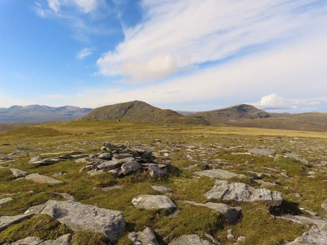
Meall an Fheur Loch (613m), the hill of the grass loch, sits west of Loch Stack and north of Loch More in the NC33 square, deep in the north-west Sutherland Geopark country. The cairn-and-rock summit looks out to Ben Stack, Arkle and the great wall of Foinaven, with the gleam of the Atlantic visible far to the west. It is one of the quieter Sutherland Grahams, with no other walkers likely on most days.
Quick facts
- Height
- 613m/ 2011ft
- Prominence
- 165 m
- Distance
- 12 km
- Ascent
- 460 m
- Time
- 3–6 hrs
- Grid ref
- NC361310
- Parking
- NC353313
- Nearest
- Ullapool· Inverness 91km
- Dogs
- Dogs on lead required near livestockDog-friendly guide ↗
Height and prominence cross-checked against the Database of British and Irish Hills (CC BY).
No GPX track yet
Walked this route? Share your track to help other walkers.
Standard route
heather moorland 65% · grass and sedge 25% · rocky summit 10%
From the small parking pull-in at NC353313 on the A838 take the stalkers' path west and then south onto rough ground above Loch Stack lodge. The line of the burn up the broad south-east shoulder is the simplest ascent. The rock-and-cairn summit lies four metres from the cairn proper — a quirk worth noting in mist. Round trip about six hours.
Terrain
Boggy heather and peat on the approach, with gneiss outcrops emerging higher up. The summit area is firm rock and short turf. The burn descending east cuts a steep slot — keep clear of it on the descent.
In winter
North-west Sutherland sits in the path of every Atlantic system that runs north of Skye and Meall an Fheur Loch can carry snow well into spring. The A838 sometimes closes briefly in storms. Daylight in December dips below seven hours; an early start and headtorch are essential for any winter attempt.
Best time of year
Getting there
- Glasgow5h 7m
- Edinburgh5h 14m
OS maps: OS Landranger 16
Mobile signal: Poor. Remote north-west Sutherland; limited coverage at best.
Current conditions
Daylight Today
- Sunrise
- 04:41
- Sunset
- 22:10
- Civil dawn
- 03:37
- Civil dusk
- 23:14
NOAA Solar Calculator · 17 July 2026
Around Meall an Fheur Loch on the SCOT network
Getting there, basing yourself, and what to do off the hill.
Meall an Fheur Loch — common questions
- How hard is Meall an Fheur Loch?
- We grade Meall an Fheur Loch at 4/5, which puts it in challenging territory. The usual route is around 12km with 460m of climbing; allow 3-6 hours. Underfoot: Boggy heather and peat on the approach, with gneiss outcrops emerging higher up.
- What is Meall an Fheur Loch's prominence?
- 165m of prominence. That's the vertical drop from the summit to the col that links Meall an Fheur Loch to the next higher ground.
- Where do I park for Meall an Fheur Loch?
- Most walkers start from NC353313 near Ullapool. Verify the grid reference on an OS map before you set off — space is tight on busy summer weekends.
- When is the best time to climb Meall an Fheur Loch?
- May, June, July, August, September give the most reliable conditions on Meall an Fheur Loch. Beyond that window the high ground turns wintry: carry full mountain kit, be confident navigating, and check the SAIS avalanche forecast for the area.
- Is Meall an Fheur Loch dog-friendly?
- Yes, but dogs must be kept on a lead — there is livestock or ground-nesting bird interest on the route.
- Is there mobile signal on Meall an Fheur Loch?
- Poor. Remote north-west Sutherland; limited coverage at best.
- Is Meall an Fheur Loch safe in winter?
- North-west Sutherland sits in the path of every Atlantic system that runs north of Skye and Meall an Fheur Loch can carry snow well into spring. The A838 sometimes closes briefly in storms. Daylight in December dips below seven hours; an early start and headtorch are essential for any winter attempt.
Get the OutdoorSCOT weekly
One email a week — new route, hill and bothy guides, seasonal conditions and the odd hard-won lesson. No spam, unsubscribe in one click.