Graham · Far North
Beinn Direach
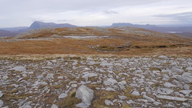
Beinn Direach (688m) — the straight hill — is a quartzite ridge in the remote moorland west of Loch Choire, set in the NC43 square deep in Sutherland's Flow Country. The summit, marked by a slabby embedded outcrop, looks out across an extraordinary emptiness of bog pools and lochans toward Ben Klibreck.
Quick facts
- Height
- 688.9m/ 2260ft
- Prominence
- 152 m
- Distance
- 13 km
- Ascent
- 564 m
- Time
- 4–6 hrs
- Grid ref
- NC406380
- Parking
- NC400385
- Nearest
- Ullapool· Inverness 96km
- Dogs
- Dogs on lead required near livestockDog-friendly guide ↗
Height and prominence cross-checked against the Database of British and Irish Hills (CC BY).
No GPX track yet
Walked this route? Share your track to help other walkers.
Standard route
heather moorland 65% · bog and wet grass 25% · grass summit 10%
From the parking at the Crask Inn on the A836 follow the estate track west for around 7km to the Bealach Easach. The hill rises directly to the north — strike up the south ridge on heather and quartzite blocks. Pathless throughout but the broad ridge is unmistakable in clear weather.
Terrain
Long estate track approach across Flow Country bog. The south ridge is dry heather and quartzite scree above 450m. The summit is a slabby quartzite outcrop set in cropped sedge.
In winter
At 58 degrees north this NC43 ridge experiences the shortest winter days in mainland Scotland, with under seven hours of daylight at midwinter. Drifting fills the burn channels and lochans deceptively. Atlantic and Arctic systems collide here and conditions can swing 20 degrees in hours.
Best time of year
Getting there
- Glasgow5h 15m
- Edinburgh5h 20m
OS maps: OS Landranger 16
Mobile signal: Poor. Fairly remote location in Cowal; limited signal on most networks.
Current conditions
Daylight Today
- Sunrise
- 04:34
- Sunset
- 22:16
- Civil dawn
- 03:26
- Civil dusk
- 23:24
NOAA Solar Calculator · 13 July 2026
On a long-distance route
Beinn Direach sits within 5km of these named long-distance walks — useful for trail-pack rest days or section extensions.
Around Beinn Direach on the SCOT network
Getting there, basing yourself, and what to do off the hill.
Beinn Direach — common questions
- Is Beinn Direach a hard climb?
- Beinn Direach is rated 4/5 (challenging) on the OutdoorSCOT scale. The standard route covers about 13km with 564m of ascent and takes most walkers 4-6 hours. Terrain: Long estate track approach across Flow Country bog.
- How prominent is Beinn Direach?
- Beinn Direach has 152m of topographic prominence — the height of its summit above the highest col connecting it to higher ground.
- Where should I park to climb Beinn Direach?
- Standard parking is at NC400385 near Ullapool. Check the parking grid reference on an OS map before travel; informal laybys can fill on summer weekends.
- When should I climb Beinn Direach?
- The standard good-weather months for Beinn Direach are May, June, July, August, September. Outside those months, expect winter conditions on the high ground — full mountain kit, navigation skills, and a check of the SAIS avalanche forecast for the relevant region.
- Can I bring my dog up Beinn Direach?
- On a lead only — the route crosses ground with livestock or nesting-bird interest.
- What's mobile reception like on Beinn Direach?
- Poor. Fairly remote location in Cowal; limited signal on most networks.
- Is Beinn Direach safe in winter?
- At 58 degrees north this NC43 ridge experiences the shortest winter days in mainland Scotland, with under seven hours of daylight at midwinter. Drifting fills the burn channels and lochans deceptively. Atlantic and Arctic systems collide here and conditions can swing 20 degrees in hours.
Get the OutdoorSCOT weekly
One email a week — new route, hill and bothy guides, seasonal conditions and the odd hard-won lesson. No spam, unsubscribe in one click.