Corbett · Far North
Ben Hee
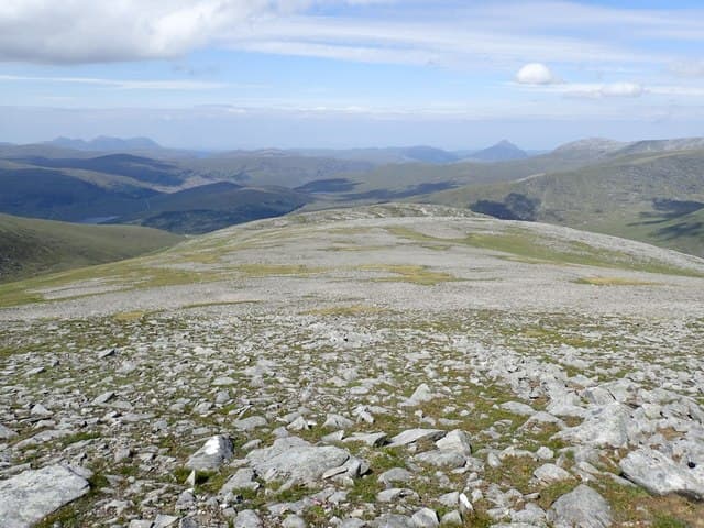
Ben Hee — the fairy mountain, from the Gaelic 'Beinn Shìth' — sits in the middle of Sutherland between Lairg and Tongue, surrounded by deer-stalking country and miles of flow country bog. It is the kind of hill that needs a specific weather window and a long drive in to enjoy, but the rewards are real: a broad rolling summit with an immense panorama across the empty interior of the county, and a strong sense of being in country very few people visit. The metrics are modest; the walk-in feels remote.
Quick facts
- Height
- 873m/ 2864ft
- Prominence
- 607 m
- Distance
- 17 km
- Ascent
- 750 m
- Time
- 4–7 hrs
- Grid ref
- NC426339
- Parking
- NC517245
- Nearest
- Ullapool· Inverness 92km
- Dogs
- Dogs on lead required near livestockDog-friendly guide ↗
Height and prominence cross-checked against the Database of British and Irish Hills (CC BY).
No GPX track yet
Walked this route? Share your track to help other walkers.
Standard route
moorland path 25% · heather hillside 45% · rocky upper slopes 20% · summit area 10%
The standard line is from the Crask Inn on the A836 (NC517245), arguably the most isolated pubs in Britain. Walk west on a Land Rover track for around 5km along the south side of Loch a' Bhealaich, then climb north-west onto the broad south-east ridge. The route rises steadily across moor and grass to the summit shelter. Return reverses the line. Allow 7–8 hours.
Terrain
Land Rover track for the first 5km gives a friendly start. From the loch end the ground turns to peat hag and rough grass — slow but rarely truly bad. The upper slopes are gentler and drier. The summit area is broad with a stone shelter built around the trig point — welcome in any wind.
In winter
Ben Hee in winter is a long quiet day in a part of Scotland that very few people see in snow. The approach Land Rover track holds drifts in north-east winds. The summit is exposed to the full sweep of Arctic systems from the Pentland Firth; clear cold conditions give one of the great Highland winter panoramas, with Foinaven, Ben Hope and the Sutherland coast all on view.
Best time of year
Getting there
- Glasgow5h 10m
- Edinburgh5h 14m
OS maps: OS Landranger 16
Mobile signal: No usable signal at Crask or on the hill — central Sutherland is a recognised mobile blackspot
Current conditions
Daylight Today
- Sunrise
- 04:34
- Sunset
- 22:15
- Civil dawn
- 03:26
- Civil dusk
- 23:23
NOAA Solar Calculator · 13 July 2026
Pair with
Curated multi-hill combinations from Ben Hee.
Around Ben Hee on the SCOT network
Getting there, basing yourself, and what to do off the hill.
Ben Hee — common questions
- What difficulty is Ben Hee?
- On the OutdoorSCOT scale, Ben Hee comes in at 3/5 — moderately challenging. Expect roughly 17km and 750m of ascent on the usual route — 4-7 hours for most parties. Ground conditions: Land Rover track for the first 5km gives a friendly start.
- How much drop does Ben Hee have?
- The drop is 607m: measured from the summit of Ben Hee down to the saddle joining it to higher terrain.
- Where's the parking for Ben Hee?
- Park at NC517245 near Ullapool. Double-check the grid reference on an OS map first; informal laybys here fill early in high season.
- What's the best month to climb Ben Hee?
- Aim for May, June, July, August, September on Ben Hee. In the remaining months treat it as a winter hill — full kit, solid navigation, and a look at the relevant SAIS avalanche forecast before you go.
- Can dogs go up Ben Hee?
- Dogs are fine on a lead. The route passes livestock or ground-nesting bird habitat, so keep them close throughout.
- Will I get phone signal on Ben Hee?
- No usable signal at Crask or on the hill — central Sutherland is a recognised mobile blackspot
- Is Ben Hee safe in winter?
- Ben Hee in winter is a long quiet day in a part of Scotland that very few people see in snow. The approach Land Rover track holds drifts in north-east winds. The summit is exposed to the full sweep of Arctic systems from the Pentland Firth; clear cold conditions give one of the great Highland winter panoramas, with Foinaven, Ben Hope and the Sutherland coast all on view.
Get the OutdoorSCOT weekly
One email a week — new route, hill and bothy guides, seasonal conditions and the odd hard-won lesson. No spam, unsubscribe in one click.