Corbett · Far North
Beinn Leoid
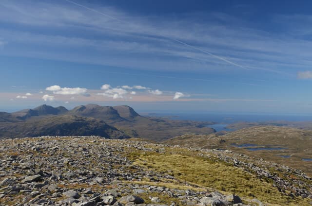
Beinn Leoid is a quiet 792m Corbett in the lonely centre of Sutherland, between Loch More and Loch Merkland. A 498m prominence puts it well clear of its neighbours, and it offers one of the empties feeling summits in the country — a boulder cairn on a wide rolling top with views in every direction across deer forest and lochan-studded moor. The hill is rarely visited; on most days the only company is a sea eagle or a herd of stags.
Quick facts
- Height
- 792m/ 2598ft
- Prominence
- 498 m
- Distance
- 14 km
- Ascent
- 649 m
- Time
- 5–8 hrs
- Grid ref
- NC320294
- Parking
- NC303256
- Nearest
- Ullapool· Inverness 91km
- Dogs
- Dogs on lead required near livestockDog-friendly guide ↗
Height and prominence cross-checked against the Database of British and Irish Hills (CC BY).
No GPX track yet
Walked this route? Share your track to help other walkers.
Standard route
estate track 30% · peat moor 35% · broad ridge 25% · boulder cairn 10%
Start from the lay-by on the A838 at the south end of Loch More and follow the rough estate track south-east toward Aultanrynie. After roughly 4km, leave the track and climb pathless heather and short-grass slopes north onto the broad south ridge of Beinn Leoid. Around 14km return with 649m of ascent. The hill is normally a single-summit day; the surrounding country is wild trackless moor.
Terrain
Estate tracks give a firm approach. Off the track the ground is wet peat and tussock — slow walking, but never technical. The summit dome is wide mossy turf with a substantial boulder cairn at the high point. There is no exposure or scrambling. The west face above Loch More holds small crag bands; keep east of the marked summit on descent.
In winter
A long winter day in remote far-north country. Gentle gradients and no avalanche concerns but the open ground offers nothing for shelter and the daylight is short above 58°N. The A838 is generally kept open along the loch. Phone signal is absent throughout; carry full emergency kit.
Best time of year
Getting there
- Glasgow5h 6m
- Edinburgh5h 14m
OS maps: OS Landranger 15
Mobile signal: No signal in central Sutherland; nothing for many kilometres in any direction
Current conditions
Daylight Today
- Sunrise
- 04:41
- Sunset
- 22:10
- Civil dawn
- 03:37
- Civil dusk
- 23:14
NOAA Solar Calculator · 17 July 2026
Pair with
Curated multi-hill combinations from Beinn Leoid.
Around Beinn Leoid on the SCOT network
Getting there, basing yourself, and what to do off the hill.
Beinn Leoid — common questions
- What difficulty is Beinn Leoid?
- On the OutdoorSCOT scale, Beinn Leoid comes in at 2/5 — moderate. Expect roughly 14km and 649m of ascent on the usual route — 5-8 hours for most parties. Terrain: Estate tracks give a firm approach.
- How prominent is Beinn Leoid?
- Beinn Leoid has 498m of topographic prominence — the height of its summit above the highest col connecting it to higher ground.
- Where should I park to climb Beinn Leoid?
- Standard parking is at NC303256 near Ullapool. Check the parking grid reference on an OS map before travel; informal laybys can fill on summer weekends.
- When should I climb Beinn Leoid?
- The standard good-weather months for Beinn Leoid are May, June, July, August, September. Outside those months, expect winter conditions on the high ground — full mountain kit, navigation skills, and a check of the SAIS avalanche forecast for the relevant region.
- Can I bring my dog up Beinn Leoid?
- On a lead only — the route crosses ground with livestock or nesting-bird interest.
- What's mobile reception like on Beinn Leoid?
- No signal in central Sutherland; nothing for many kilometres in any direction
- Is Beinn Leoid safe in winter?
- A long winter day in remote far-north country. Gentle gradients and no avalanche concerns but the open ground offers nothing for shelter and the daylight is short above 58°N. The A838 is generally kept open along the loch. Phone signal is absent throughout; carry full emergency kit.
Get the OutdoorSCOT weekly
One email a week — new route, hill and bothy guides, seasonal conditions and the odd hard-won lesson. No spam, unsubscribe in one click.