Corbett · Far North
Glas Bheinn
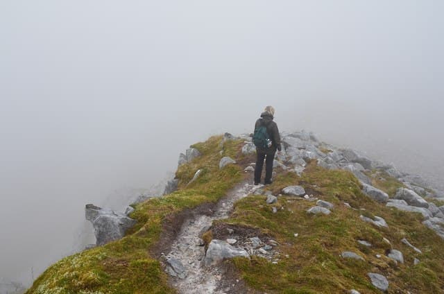
Glas Bheinn — the grey-green hill — is the modest Corbett sitting between Quinag to the north and the Inchnadamph valley to the south, surrounded by the Assynt limestone country. Most visitors pass it without a glance on their way to Quinag or Suilven, which is part of its appeal: a quiet summit with amongst the best Assynt views, looking east over lochan-spotted moor to Conival and Ben More Assynt, west to Suilven, and north to Quinag and the Atlantic. The summit also overlooks the gorge of the Eas a' Chual Aluinn — Britain's tallest waterfall at 200m — though the falls themselves are best appreciated from a separate detour.
Gaelic: “grey-green” · Pronunciation: glass bheinn
Quick facts
- Height
- 776m/ 2546ft
- Prominence
- 159 m
- Distance
- 9 km
- Ascent
- 580 m
- Time
- 2–4 hrs
- Grid ref
- NC254265
- Parking
- NC237284
- Nearest
- Ullapool· Inverness 91km
- Dogs
- Dogs on lead required near livestockDog-friendly guide ↗
Height and prominence cross-checked against the Database of British and Irish Hills (CC BY).
No GPX track yet
Walked this route? Share your track to help other walkers.
Standard route
moorland path 25% · heather and grass 45% · grassy upper ridge 20% · summit area 10%
Park at the layby on the A894 near the Skiag Bridge end of Loch Assynt (NC237284). Cross the road and follow the obvious path east into the small glen, climbing gently to a bealach below the south-west ridge of Glas Bheinn. From the bealach, climb north-east up a clear path to the summit cairn. Many parties combine the summit with a side-trip from the bealach to the lip of the Eas a' Chual Aluinn falls, a path-marked route heading south-east. Allow 4–5 hours for Glas Bheinn alone.
Terrain
A clear path most of the way — unusually well-trodden for a Sutherland Corbett because of the proximity to Skiag Bridge. The terrain is heather, grass and exposed Lewisian gneiss outcrops. The summit area is a broad stony plateau with an obvious large cairn. Drier than the surrounding peat moorlands thanks to the underlying limestone-dappled geology.
In winter
A friendly winter Corbett by Sutherland standards — short approach, clear path, no avalanche issues on the standard ridge. Snow holds on the east aspect. The Skiag Bridge approach is well-cleared by the council. The summit holds the wind from any northerly direction; carry a windproof.
Best time of year
Getting there
- Glasgow5h 3m
- Edinburgh5h 13m
OS maps: OS Landranger 15
Mobile signal: Brief EE/Vodafone at the Skiag Bridge layby; no signal once into the small glen east of the A894
Current conditions
Daylight Today
- Sunrise
- 04:35
- Sunset
- 22:16
- Civil dawn
- 03:28
- Civil dusk
- 23:23
NOAA Solar Calculator · 13 July 2026
Pair with
Curated multi-hill combinations from Glas Bheinn.
On a long-distance route
Glas Bheinn sits within 5km of these named long-distance walks — useful for trail-pack rest days or section extensions.
Around Glas Bheinn on the SCOT network
Getting there, basing yourself, and what to do off the hill.
Glas Bheinn — common questions
- What difficulty is Glas Bheinn?
- On the OutdoorSCOT scale, Glas Bheinn comes in at 2/5 — moderate. Expect roughly 9km and 580m of ascent on the usual route — 2-4 hours for most parties. Terrain: A clear path most of the way — unusually well-trodden for a Sutherland Corbett because of the proximity to Skiag Bridge.
- How prominent is Glas Bheinn?
- Glas Bheinn has 159m of topographic prominence — the height of its summit above the highest col connecting it to higher ground.
- Where should I park to climb Glas Bheinn?
- Standard parking is at NC237284 near Ullapool. Check the parking grid reference on an OS map before travel; informal laybys can fill on summer weekends.
- When should I climb Glas Bheinn?
- The standard good-weather months for Glas Bheinn are May, June, July, August, September. Outside those months, expect winter conditions on the high ground — full mountain kit, navigation skills, and a check of the SAIS avalanche forecast for the relevant region.
- Can I bring my dog up Glas Bheinn?
- On a lead only — the route crosses ground with livestock or nesting-bird interest.
- What's mobile reception like on Glas Bheinn?
- Brief EE/Vodafone at the Skiag Bridge layby; no signal once into the small glen east of the A894
- Is Glas Bheinn safe in winter?
- A friendly winter Corbett by Sutherland standards — short approach, clear path, no avalanche issues on the standard ridge. Snow holds on the east aspect. The Skiag Bridge approach is well-cleared by the council. The summit holds the wind from any northerly direction; carry a windproof.
Get the OutdoorSCOT weekly
One email a week — new route, hill and bothy guides, seasonal conditions and the odd hard-won lesson. No spam, unsubscribe in one click.