Long distance
Sutherland Trail
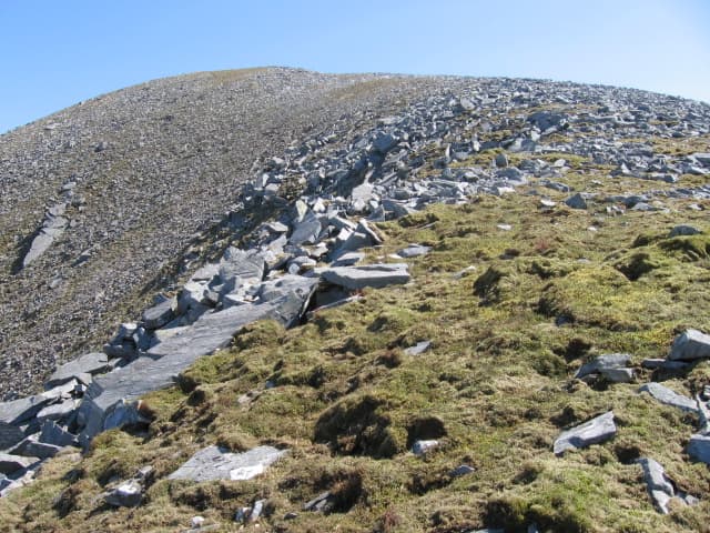
An unofficial route through the wildest landscape in mainland Britain. Passes Suilven, Canisp, Ben More Assynt and the limestone karst of Knockan Crag. No waymarks, no crowds, no safety net. Around 112 km (70 mi) point-to-point and 3,200 m up; allow 6 days. Mostly unwaymarked.
Quick facts
- Distance
- 112 km/ 70 mi
- Typical days
- 6
- Total ascent
- 3200 m
- Difficulty
- challenging
- Start → Finish
- Lochinver → Tongue
- Best direction
- West to East
- Water sources
- Lochinver, Inchnadamph (lodge), Knockdamph (bothy — burn nearby), Crask Inn, Altnaharra, Syre, Tongue — these are the only fill points. The Sutherland landscape has many burns and rivers but they cross trackless ground. Treat everything. Carry 2L on the Crask-to-Altnaharra leg.
- Mobile signal
- EE/Vodafone only at Lochinver, the Crask Inn (intermittent), Altnaharra (Hotel) and Tongue. The interior — Knockdamph, Strathnaver, the Flow Country approach — is entirely out of signal. Carry a satellite messenger.
⚠ Not waymarked — navigation skills required
Approximate profile derived from per-stage ascent — accurate on total climb and pattern, not a pixel-precise GPX trace.
Our take
The Sutherland Trail is for experienced backpackers who want genuine wilderness without the Cape Wrath Trail's length. The mountain scenery is extraordinary — Suilven, Canisp and the Assynt peaks are unlike anything else in Scotland. Navigation skills are essential as the route is unmarked and passes through trackless terrain. Midges in July will test your commitment to outdoor living.
Highlights
- Suilven — the most distinctive mountain in Scotland
- Ben More Assynt
- Knockan Crag geological trail
- Loch Shin and the Flow Country approach
Day-by-day itinerary
A suggested 6-day schedule. Adjust to your fitness and conditions.
1Lochinver to Inchnadamph22km · 600m ascent
East from Lochinver through the Assynt landscape past Suilven — Scotland's most distinctive mountain — to Inchnadamph Lodge on Loch Assynt.
- Terrain
- Rough moorland paths, trackless ground, some river crossings. Navigation essential.
- Overnight
- Inchnadamph Lodge hostel. Wild camping near the loch.
- Stats
- Lochinver → Inchnadamph · 22km · ↑600m
2Inchnadamph to Knockdamph18km · 550m ascent
Past the geological wonder of Knockan Crag and over the hills towards Ben More Assynt. Truly remote terrain with no habitation.
- Terrain
- Hill paths, rough moorland, river crossings. Remote and demanding.
- Overnight
- Knockdamph bothy or wild camping. No other options.
- Stats
- Inchnadamph → Knockdamph Bothy · 18km · ↑550m
3Knockdamph to Crask Inn20km · 550m ascent
Through the empty heart of Sutherland past Loch Shin. The landscape is vast and treeless — the Flow Country begins to dominate.
- Terrain
- Rough paths, moorland, bog. Slow going in wet conditions.
- Overnight
- Crask Inn — one of Britain's most remote pubs. Wild camping.
- Stats
- Knockdamph Bothy → Crask Inn · 20km · ↑550m
4Crask Inn to Altnaharra16km · 400m ascent
Along Loch Shin and over to Loch Naver at Altnaharra. The hamlet holds the UK's cold temperature record and has a genuine end-of-the-world feel.
- Terrain
- Loch-shore paths, moorland tracks, some road walking.
- Overnight
- Altnaharra Hotel. Wild camping by Loch Naver.
- Stats
- Crask Inn → Altnaharra · 16km · ↑400m
5Altnaharra to Syre18km · 500m ascent
Down Strathnaver — the valley of the Highland Clearances. The Clearance memorials and ruined townships are deeply moving.
- Terrain
- Glen paths, riverside tracks, farm roads.
- Overnight
- Syre has very limited options. Wild camping in the glen.
- Stats
- Altnaharra → Syre · 18km · ↑500m
6Syre to Tongue18km · 500m ascent
Over the final hills to the north coast at Tongue, with views to Ben Hope and Ben Loyal. The Kyle of Tongue and Castle Varrich mark the finish.
- Terrain
- Hill paths, moorland, descent to the coast.
- Overnight
- Tongue has the Ben Loyal Hotel and B&Bs. Bus connections east and west along the north coast.
- Stats
- Syre → Tongue · 18km · ↑500m
Hills along the route
Munros, Corbetts, Grahams and Donalds within 5km of the route line — extensions or rest-day options.
Best months
Accommodation
Lochinver, Inchnadamph and Altnaharra have limited B&Bs. Wild camping is the primary option. Inchnadamph Lodge hostel is a welcome mid-route stop. Limited B&Bs at Lochinver, Altnaharra and Tongue; Inchnadamph Lodge hostel and Crask Inn are the only mid-route indoor stops. Wild camping is the primary plan for everyone.
Night-by-night guide: where to stay →Resupply
Lochinver has a good shop. Inchnadamph has nothing. No resupply between Lochinver and Tongue (5 days). Carry all food. Co-op at Lochinver and small shop at Tongue; nothing reliable between (5 days of food). Postal-drop to Inchnadamph Lodge or Crask Inn is possible by arrangement.
Current conditions
Weather at the start point (Lochinver)
Daylight Today
- Sunrise
- 05:09
- Sunset
- 21:46
- Civil dawn
- 04:13
- Civil dusk
- 22:42
NOAA Solar Calculator · 30 July 2026
Share your experience
Walked the Sutherland Trail? Help others plan their trip.
Getting to and from the Sutherland Trail
Train and town anchors at each end of the route — on TripSCOT.