Corbett · Cairngorms
Corryhabbie Hill
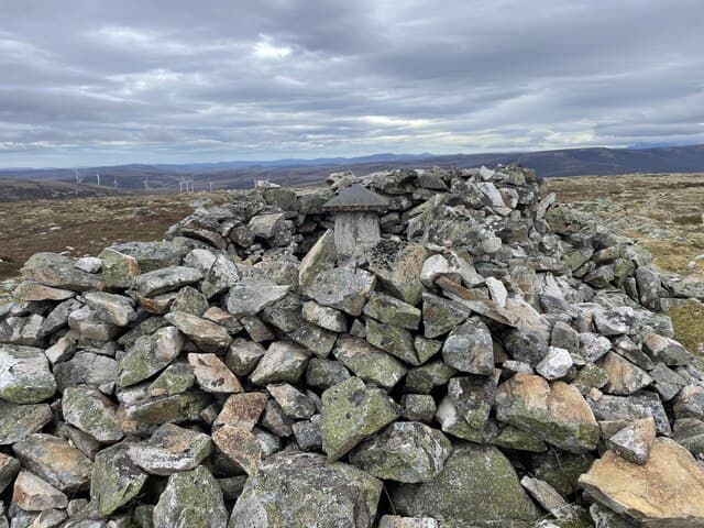
Corryhabbie Hill is a 781m Corbett in the rolling whisky-country uplands east of Tomintoul, between Glenlivet and the Cabrach. A trig pillar inside a stone windshelter marks the summit on a broad heather plateau. The view stretches east to the Moray coast and west to the Cairngorm plateau; on clear days the Inverness firths are visible. Like nearby Ben Rinnes the hill is a popular fitness target for locals from Dufftown and Tomintoul.
Quick facts
- Height
- 781.3m/ 2563ft
- Prominence
- 280 m
- Distance
- 14 km
- Ascent
- 640 m
- Time
- 4–7 hrs
- Grid ref
- NJ280288
- Parking
- NJ218256
- Nearest city
- Inverness· 63km
- Dogs
- Dogs on lead required near livestockDog-friendly guide ↗
Height and prominence cross-checked against the Database of British and Irish Hills (CC BY).
No GPX track yet
Walked this route? Share your track to help other walkers.
Standard route
hill track 35% · open heather 35% · broad plateau 20% · trig shelter 10%
Park at the small lay-by near Tomnavoulin on the B9008 in Glenlivet and follow the public hill track east up Glen Suie. About 4km up the track, leave it and push pathless north through heather to gain the broad south ridge of Corryhabbie Hill. A steady gradient on the ridge brings the summit shelter. Some 14km out-and-back with 640m of climbing. Most parties tackle it on its own — the surrounding country is heathery moorland with no obvious neighbours.
Terrain
The Glen Suie hill track is firm gravel. Beyond the track the surface is short heather mixed with occasional peat hag — easy walking but pathless. The summit plateau is broad heather and short grass with the trig shelter unmistakable. No exposure or scrambling. Stalking activity from August to October — check ahead.
In winter
A reliable winter Corbett — gentle gradients, no avalanche concerns, broad summit plateau picks up significant easterly snowfall. The B9008 is gritted and reliable. The hill track itself ices over in cold snaps. Daylight in midwinter is short but the modest approach keeps a single hill within reach.
This hill is in the Northern Cairngorms SAIS forecast area. Check SAIS forecasts in winter (December–April).
Best time of year
Getting there
- Glasgow3h 24m
- Edinburgh3h 59m
OS maps: OS Landranger 37
Mobile signal: Reasonable signal in Glenlivet; usable on the summit
Current conditions
Daylight Today
- Sunrise
- 04:41
- Sunset
- 21:57
- Civil dawn
- 03:41
- Civil dusk
- 22:57
NOAA Solar Calculator · 17 July 2026
Pair with
Curated multi-hill combinations from Corryhabbie Hill.
Around Corryhabbie Hill on the SCOT network
Getting there, basing yourself, and what to do off the hill.
Getting there: Aviemore station
Cairngorm plateau; Lairig Ghru; Speyside Way; Glenmore
41km from the hill
tripscot.co.uk
On TripSCOTBase yourself in Dufftown
Speyside whisky town in the eastern Cairngorms
12km from the hill
tripscot.co.uk
On TasteSCOTAfter the hill: The Glenlivet
Ballindalloch — the first legal distillery under the 1823 Excise Act
2km from the hill
tastescot.co.uk
Corryhabbie Hill — common questions
- How difficult is Corryhabbie Hill?
- Corryhabbie Hill carries a 2/5 (moderate) grade on the OutdoorSCOT scale. Count on about 14km, 640m of ascent and a 4-7 hour day on the standard route. Underfoot: The Glen Suie hill track is firm gravel.
- What is Corryhabbie Hill's prominence?
- 280m of prominence. That's the vertical drop from the summit to the col that links Corryhabbie Hill to the next higher ground.
- Where do I park for Corryhabbie Hill?
- Most walkers start from NJ218256. Verify the grid reference on an OS map before you set off — space is tight on busy summer weekends.
- When is the best time to climb Corryhabbie Hill?
- April, May, June, July, August, September, October give the most reliable conditions on Corryhabbie Hill. Beyond that window the high ground turns wintry: carry full mountain kit, be confident navigating, and check the SAIS avalanche forecast for the area.
- Is Corryhabbie Hill dog-friendly?
- Yes, but dogs must be kept on a lead — there is livestock or ground-nesting bird interest on the route.
- Is there mobile signal on Corryhabbie Hill?
- Reasonable signal in Glenlivet; usable on the summit
- Is Corryhabbie Hill safe in winter?
- A reliable winter Corbett — gentle gradients, no avalanche concerns, broad summit plateau picks up significant easterly snowfall. The B9008 is gritted and reliable. The hill track itself ices over in cold snaps. Daylight in midwinter is short but the modest approach keeps a single hill within reach.
Get the OutdoorSCOT weekly
One email a week — new route, hill and bothy guides, seasonal conditions and the odd hard-won lesson. No spam, unsubscribe in one click.