Graham · Cairngorms
Carn a' Ghille Chearr
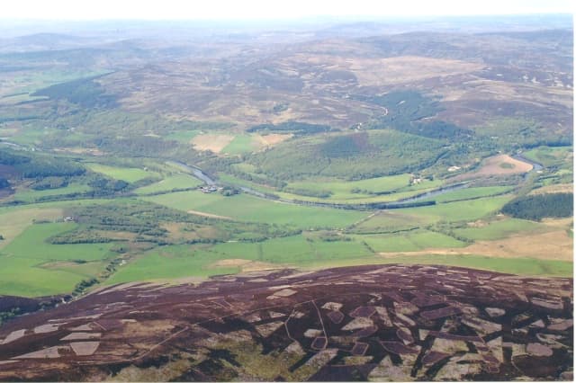
Carn a' Ghille Chearr (710m) — the cairn of the wrong lad — is the high point of the Cromdale Hills at NJ13, a broad granite ridge between Strathspey and Glenlivet. The trig pillar perches on a long whaleback of heather and granite, looking down on the Battle of Cromdale ground of 1690 and across Speyside to Cairn Gorm and Bynack More. The ridge offers some of the loneliest grouse-moor walking outside the central Cairngorms.
Quick facts
- Height
- 710.2m/ 2330ft
- Prominence
- 179 m
- Distance
- 13 km
- Ascent
- 582 m
- Time
- 4–6 hrs
- Grid ref
- NJ139298
- Parking
- NJ121271
- Nearest city
- Inverness· 50km
- Dogs
- Dogs on lead required near livestockDog-friendly guide ↗
Height and prominence cross-checked against the Database of British and Irish Hills (CC BY).
No GPX track yet
Walked this route? Share your track to help other walkers.
Standard route
heather moorland 65% · grass slopes 25% · summit plateau 10%
From the Tomintoul road parking near Bridge of Brown (NJ121271), a long estate track climbs steadily south onto the broad ridge crest. The summit lies near the south end of an undulating roof of heather and bog. 13km return on the standard out-and-back, 582m climbed. A traverse from Cromdale village in Strathspey makes a longer linear option with car-shuttle.
Terrain
Estate landrover tracks reach about 550m on burned-strip heather, then the upper plateau is on bilberry, moss and granite chips. The summit dome carries a small ring of stones around the trig. Bog patches drain slowly between the heather strips — gaiters help year-round.
In winter
Cromdale plateau is fully exposed to easterly winds and accumulates dense windslab during Cairngorm storm cycles — SAIS Northern Cairngorms gives the most relevant snow forecast. The trig is a useful visibility check in cloud, but pacing-and-compass discipline is essential on the broad ridge.
This hill is in the Northern Cairngorms SAIS forecast area. Check SAIS forecasts in winter (December–April).
Best time of year
Getting there
- Glasgow3h 20m
- Edinburgh3h 0m
OS maps: OS Landranger 36
Mobile signal: Mixed. EE unreliable on top; better on west-facing slopes toward Strathspey.
Current conditions
Daylight Today
- Sunrise
- 04:36
- Sunset
- 22:03
- Civil dawn
- 03:33
- Civil dusk
- 23:06
NOAA Solar Calculator · 13 July 2026
Around Carn a' Ghille Chearr on the SCOT network
Getting there, basing yourself, and what to do off the hill.
Getting there: Aviemore station
Cairngorm plateau; Lairig Ghru; Speyside Way; Glenmore
30km from the hill
tripscot.co.uk
On TripSCOTBase yourself in Dufftown
Speyside whisky town in the eastern Cairngorms
21km from the hill
tripscot.co.uk
On TasteSCOTAfter the hill: Cragganmore
Ballindalloch — quietly excellent Speysider; Classic Malts visitor experience
7km from the hill
tastescot.co.uk
Carn a' Ghille Chearr — common questions
- What difficulty is Carn a' Ghille Chearr?
- On the OutdoorSCOT scale, Carn a' Ghille Chearr comes in at 4/5 — challenging. Expect roughly 13km and 582m of ascent on the usual route — 4-6 hours for most parties. Underfoot: Estate landrover tracks reach about 550m on burned-strip heather, then the upper plateau is on bilberry, moss and granite chips.
- What is Carn a' Ghille Chearr's prominence?
- 179m of prominence. That's the vertical drop from the summit to the col that links Carn a' Ghille Chearr to the next higher ground.
- Where do I park for Carn a' Ghille Chearr?
- Most walkers start from NJ121271. Verify the grid reference on an OS map before you set off — space is tight on busy summer weekends.
- When is the best time to climb Carn a' Ghille Chearr?
- April, May, June, July, August, September, October give the most reliable conditions on Carn a' Ghille Chearr. Beyond that window the high ground turns wintry: carry full mountain kit, be confident navigating, and check the SAIS avalanche forecast for the area.
- Is Carn a' Ghille Chearr dog-friendly?
- Yes, but dogs must be kept on a lead — there is livestock or ground-nesting bird interest on the route.
- Is there mobile signal on Carn a' Ghille Chearr?
- Mixed. EE unreliable on top; better on west-facing slopes toward Strathspey.
- Is Carn a' Ghille Chearr safe in winter?
- Cromdale plateau is fully exposed to easterly winds and accumulates dense windslab during Cairngorm storm cycles — SAIS Northern Cairngorms gives the most relevant snow forecast. The trig is a useful visibility check in cloud, but pacing-and-compass discipline is essential on the broad ridge.
Get the OutdoorSCOT weekly
One email a week — new route, hill and bothy guides, seasonal conditions and the odd hard-won lesson. No spam, unsubscribe in one click.