Corbett · Cairngorms
Ben Rinnes
Ben Rinnes is the iconic hill of Speyside — the great heather-clad whaleback rising above the Glenlivet, Aberlour and Knockando distilleries, visible from much of the Moray coast. Standing well apart from the Cairngorms proper to the south, its 840m summit is crowned by a series of weathered granite tors, the largest of which is known locally as the Scurran of Lochterlandoch. The view from the top takes in the Moray Firth, the Cairngorms, the Buck of Cabrach and on a clear day all the way to Caithness.
Quick facts
- Height
- 840.9m/ 2759ft
- Prominence
- 513 m
- Distance
- 15 km
- Ascent
- 739 m
- Time
- 5–7 hrs
- Grid ref
- NJ254354
- Parking
- NJ285354
- Nearest city
- Inverness· 59km
- Dogs
- Dogs on lead required near livestockDog-friendly guide ↗
Height and prominence cross-checked against the Database of British and Irish Hills (CC BY).
No GPX track yet
Walked this route? Share your track to help other walkers.
Standard route
moorland path 30% · heather moorland 40% · stony path 20% · summit rocks 10%
The standard route starts from the Glack Harnes car park on the back road from Dufftown to Glenlivet and follows the well-built path direct up the east ridge — short, steep and unmistakable. The path reaches the summit tors after a 4km, 600m ascent and most parties return the same way for around 8km total. Longer rounds extend over the subsidiary tops Roy's Hill and Round Hill back to the road; total return up to 15km with 739m of ascent depending on the line taken.
Terrain
The main path from Glack Harnes is well used by locals and well maintained, with stone-pitched sections on the steeper pulls. Heather and exposed peat dominate the moorland flanks — the path saves much of the boot-sucking that would otherwise be involved. Around the summit tors, weathered granite gives clean blocky walking with no exposure. Watch for grouse butts and active shooting tracks on the lower slopes in season.
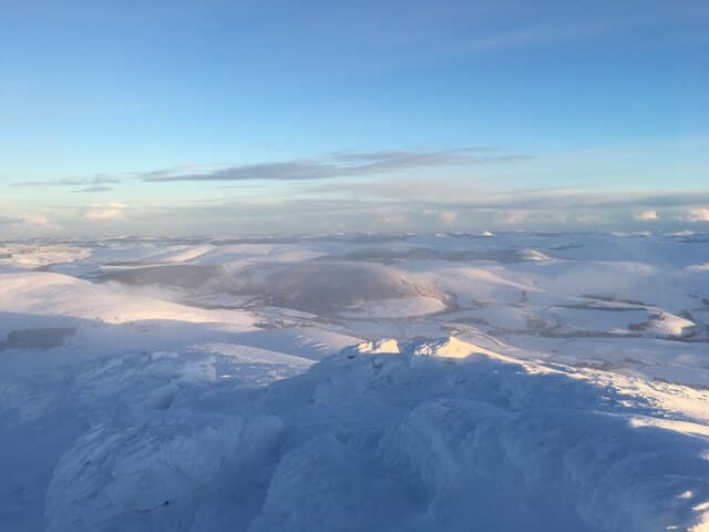
In winter
Ben Rinnes catches more snow than its modest height would suggest — its isolated position above Speyside means it picks up easterly snowfalls that miss the higher hills further west. The summit tors are exposed and rime-encrusted for much of January and February. Snow drifts can hide the path on the upper ridge; ice axe and crampons are useful above 600m in a hard winter. The Glack Harnes road can be closed by drifting snow.
This hill is in the Northern Cairngorms SAIS forecast area. Check SAIS forecasts in winter (December–April).
Best time of year
Getting there
- Glasgow4h 30m
- Edinburgh3h 6m
OS maps: OS Landranger 28
Mobile signal: Good signal on this accessible Speyside hill — 3 bars at the cairn
Current conditions
Daylight Today
- Sunrise
- 04:35
- Sunset
- 22:03
- Civil dawn
- 03:32
- Civil dusk
- 23:06
NOAA Solar Calculator · 13 July 2026
Pair with
Curated multi-hill combinations from Ben Rinnes.
Around Ben Rinnes on the SCOT network
Getting there, basing yourself, and what to do off the hill.
Getting there: Aviemore station
Cairngorm plateau; Lairig Ghru; Speyside Way; Glenmore
42km from the hill
tripscot.co.uk
On TripSCOTBase yourself in Dufftown
Speyside whisky town in the eastern Cairngorms
8km from the hill
tripscot.co.uk
On TasteSCOTAfter the hill: Glenfarclas
Ballindalloch — family-owned Speysider; sherry-cask powerhouse
3km from the hill
tastescot.co.uk
Ben Rinnes — common questions
- Is Ben Rinnes a hard climb?
- Ben Rinnes is rated 3/5 (moderately challenging) on the OutdoorSCOT scale. The standard route covers about 15km with 739m of ascent and takes most walkers 5-7 hours. Ground conditions: The main path from Glack Harnes is well used by locals and well maintained, with stone-pitched sections on the steeper pulls.
- How much drop does Ben Rinnes have?
- The drop is 513m: measured from the summit of Ben Rinnes down to the saddle joining it to higher terrain.
- Where's the parking for Ben Rinnes?
- Park at NJ285354. Double-check the grid reference on an OS map first; informal laybys here fill early in high season.
- What's the best month to climb Ben Rinnes?
- Aim for April, May, June, July, August, September, October on Ben Rinnes. In the remaining months treat it as a winter hill — full kit, solid navigation, and a look at the relevant SAIS avalanche forecast before you go.
- Can dogs go up Ben Rinnes?
- Dogs are fine on a lead. The route passes livestock or ground-nesting bird habitat, so keep them close throughout.
- Will I get phone signal on Ben Rinnes?
- Good signal on this accessible Speyside hill — 3 bars at the cairn
- Is Ben Rinnes safe in winter?
- Ben Rinnes catches more snow than its modest height would suggest — its isolated position above Speyside means it picks up easterly snowfalls that miss the higher hills further west. The summit tors are exposed and rime-encrusted for much of January and February. Snow drifts can hide the path on the upper ridge; ice axe and crampons are useful above 600m in a hard winter. The Glack Harnes road can be closed by drifting snow.
Get the OutdoorSCOT weekly
One email a week — new route, hill and bothy guides, seasonal conditions and the odd hard-won lesson. No spam, unsubscribe in one click.