Munro · Central Highlands
Chno Dearg
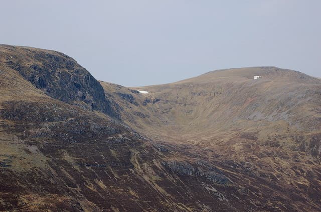
Chno Dearg (1046m) — "red nut" — is the higher of the two Munros above the deep glacial trench of Loch Treig, paired with Stob Coire Sgriodain to the south-west. It is a broad whaleback summit looking out over the West Highland Line as it runs along the shore of Loch Treig to Corrour. Best climbed as a horseshoe of both Munros from the small hamlet of Fersit, which sits at the head of the loch and the start of the rough track south.
Gaelic: “red” · Pronunciation: chno jerr-ak
Quick facts
- Height
- 1046m/ 3432ft
- Prominence
- 644 m
- Distance
- ~18 km
- Ascent
- ~920 m
- Time
- 6–9 hrs
- Grid ref
- NN377741
- Parking
- NN350781
- Nearest city
- Fort William· 27km
- Dogs
- Dogs on lead required near livestockDog-friendly guide ↗
Height and prominence cross-checked against the Database of British and Irish Hills (CC BY).
No GPX track yet
Walked this route? Share your track to help other walkers.
Standard route
Track / open hillside 35% · Open ridge 40% · Summit 25%
Park at Fersit at the end of the side road off the A86 west of Tulloch. Cross the railway via the level crossing and climb the broad north-west ridge of Stob Coire Sgriodain, with views straight down the length of Loch Treig. From Sgriodain drop east-south-east to the col and climb directly onto Chno Dearg via its broad west shoulder. Return north over Meall Garbh and down to Fersit. Around 14km with 1100m of ascent for the pair; Chno Dearg alone is 11km with 850m up.
Terrain
The Fersit approach crosses the railway line — be alert, this is the working West Highland Line. Above the crossing the ground is wet boggy moor with no clear path; pick a line up to the broad north-west ridge of Sgriodain. Higher up the ridges turn to short grass and gravel, easy walking. The bealach between Sgriodain and Chno Dearg is broad and wet. The summit area of Chno Dearg is a large flat top with the cairn marking the modest high point.
In winter
A relatively benign winter Munro pair, but the open whaleback summits are fully exposed to westerly weather coming off Rannoch Moor. The east face of Chno Dearg above Coire an Easain Bhig holds wind-loaded snow. The A86 to Fersit is gritted but the Fersit side road can drift closed. Phone signal is intermittent. SAIS Creag Meagaidh applies to the western corries.
Kit for this: the winter Munro kit list · which boots take crampons
This hill is in the Creag Meagaidh SAIS forecast area. Check SAIS forecasts in winter (December–April).
Best time of year
Getting there
- Glasgow2h 21m
- Edinburgh3h 50m
OS maps: OS Landranger 41
Mobile signal: Nothing above 700m. Fersit village has occasional signal. Download mapping before the run from Tulloch or Spean Bridge.
Current conditions
Daylight Today
- Sunrise
- 08:06
- Sunset
- 18:01
- Civil dawn
- 07:27
- Civil dusk
- 18:40
NOAA Solar Calculator · 22 October 2026
Pair with
Curated multi-hill combinations from Chno Dearg.
Around Chno Dearg on the SCOT network
Getting there, basing yourself, and what to do off the hill.
Chno Dearg — common questions
- What difficulty is Chno Dearg?
- On the OutdoorSCOT scale, Chno Dearg comes in at 3/5 — moderately challenging. Expect roughly 18km and 920m of ascent on the usual route — 6-9 hours for most parties. Terrain: The Fersit approach crosses the railway line — be alert, this is the working West Highland Line.
- How prominent is Chno Dearg?
- Chno Dearg has 644m of topographic prominence — the height of its summit above the highest col connecting it to higher ground.
- Where should I park to climb Chno Dearg?
- Standard parking is at NN350781. Check the parking grid reference on an OS map before travel; informal laybys can fill on summer weekends.
- When should I climb Chno Dearg?
- The standard good-weather months for Chno Dearg are May, June, July, August, September, October. Outside those months, expect winter conditions on the high ground — full mountain kit, navigation skills, and a check of the SAIS avalanche forecast for the relevant region.
- Can I bring my dog up Chno Dearg?
- On a lead only — the route crosses ground with livestock or nesting-bird interest.
- What's mobile reception like on Chno Dearg?
- Nothing above 700m. Fersit village has occasional signal. Download mapping before the run from Tulloch or Spean Bridge.
- Is Chno Dearg safe in winter?
- A relatively benign winter Munro pair, but the open whaleback summits are fully exposed to westerly weather coming off Rannoch Moor. The east face of Chno Dearg above Coire an Easain Bhig holds wind-loaded snow. The A86 to Fersit is gritted but the Fersit side road can drift closed. Phone signal is intermittent. SAIS Creag Meagaidh applies to the western corries.
Get the OutdoorSCOT weekly
One email a week — new route, hill and bothy guides, seasonal conditions and the odd hard-won lesson. No spam, unsubscribe in one click.