Graham · Skye & The Small Isles
Ben Aslak
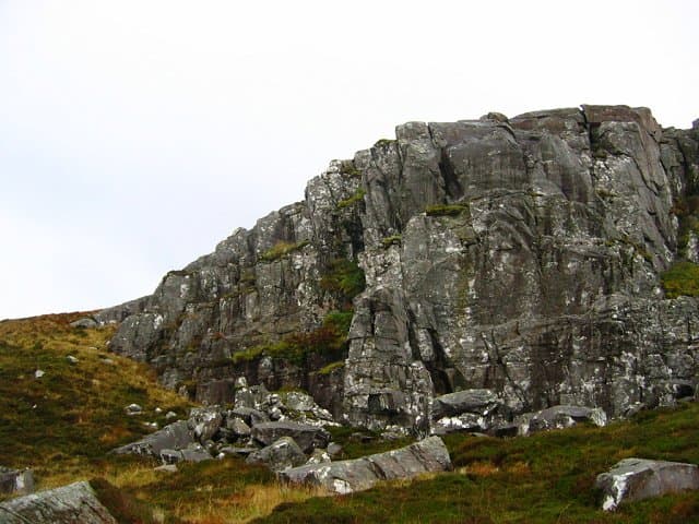
Ben Aslak (609m) is a twin-topped Graham rising directly above the Kylerhea narrows on the southern Skye peninsula. Sitting in the NG75 square, its rocky knoll summit looks across the tidal strait to Glenelg, with the Knoydart peaks filling the southern horizon and the Cuillin visible to the west on clear days. The hill marks the watershed between Loch na Dal and the Kylerhea river, and feels far wilder than its modest height suggests. The nearest settlement is Broadford on Skye.
Quick facts
- Height
- 609m/ 1998ft
- Prominence
- 329 m
- Distance
- 12 km
- Ascent
- 457 m
- Time
- 3–6 hrs
- Grid ref
- NG750191
- Parking
- NG753206
- Nearest
- Fort William· Inverness 95km
- Dogs
- Dogs on lead required near livestockDog-friendly guide ↗
Height and prominence cross-checked against the Database of British and Irish Hills (CC BY).
No GPX track yet
Walked this route? Share your track to help other walkers.
Standard route
heather moorland 55% · rocky hillside 30% · grass and bog 15%
Most parties start from the small layby on the Kylerhea road near NG753206, climbing northwest onto the broad heather-clad shoulder before working southwest toward the twin summit knolls. The route covers around 12km with 457m of ascent and is best done as an out-and-back along the same line — the south-west top is the true summit. Expect tussocky going underfoot for the first kilometre, with bare gneiss slabs emerging higher up and a final scramble onto the rocky crown.
Terrain
Almost entirely pathless — a couple of faint trods peter out in the heather, and you navigate by the lie of the ground. The bealach between the two summit knolls is broken by small crags and short slabby steps that can be passed on either side. In poor visibility the twin tops can be confusing; carry a compass and trust the bearing rather than the ground.
In winter
Snow lies only briefly on the Kylerhea hills, but when it does the deer-grass slopes turn glassy and the small crags around the bealach hold verglas long after the air has warmed. A south-westerly gale here funnels straight off the Sound of Sleat with little to break it. Pick a settled high-pressure window in February or March and you can have the twin tops to yourself.
Best time of year
Getting there
- Glasgow3h 22m
- Edinburgh4h 1m
OS maps: OS Landranger 33
Mobile signal: Poor. Remote Knoydart/Glenelg area; very limited coverage.
Current conditions
Daylight Today
- Sunrise
- 04:46
- Sunset
- 22:11
- Civil dawn
- 03:44
- Civil dusk
- 23:13
NOAA Solar Calculator · 13 July 2026
Around Ben Aslak on the SCOT network
Getting there, basing yourself, and what to do off the hill.
Getting there: Kyle of Lochalsh station
Skye Bridge; Five Sisters of Kintail; Glen Shiel; Plockton
8km from the hill
tripscot.co.uk
On TripSCOTBase yourself in Mallaig
Ferry port for Skye and the Small Isles; CWT finish supply
23km from the hill
tripscot.co.uk
On TasteSCOTAfter the hill: Isle of Raasay Distillery
Raasay — new island distillery with rooms; Dun Caan walks from the door
27km from the hill
tastescot.co.uk
Ben Aslak — common questions
- What difficulty is Ben Aslak?
- On the OutdoorSCOT scale, Ben Aslak comes in at 4/5 — challenging. Expect roughly 12km and 457m of ascent on the usual route — 3-6 hours for most parties. Underfoot: Almost entirely pathless — a couple of faint trods peter out in the heather, and you navigate by the lie of the ground.
- What is Ben Aslak's prominence?
- 329m of prominence. That's the vertical drop from the summit to the col that links Ben Aslak to the next higher ground.
- Where do I park for Ben Aslak?
- Most walkers start from NG753206 near Fort William. Verify the grid reference on an OS map before you set off — space is tight on busy summer weekends.
- When is the best time to climb Ben Aslak?
- May, June, July, August, September give the most reliable conditions on Ben Aslak. Beyond that window the high ground turns wintry: carry full mountain kit, be confident navigating, and check the SAIS avalanche forecast for the area.
- Is Ben Aslak dog-friendly?
- Yes, but dogs must be kept on a lead — there is livestock or ground-nesting bird interest on the route.
- Is there mobile signal on Ben Aslak?
- Poor. Remote Knoydart/Glenelg area; very limited coverage.
- Is Ben Aslak safe in winter?
- Snow lies only briefly on the Kylerhea hills, but when it does the deer-grass slopes turn glassy and the small crags around the bealach hold verglas long after the air has warmed. A south-westerly gale here funnels straight off the Sound of Sleat with little to break it. Pick a settled high-pressure window in February or March and you can have the twin tops to yourself.
Get the OutdoorSCOT weekly
One email a week — new route, hill and bothy guides, seasonal conditions and the odd hard-won lesson. No spam, unsubscribe in one click.