Graham · Skye & The Small Isles
Beinn na Caillich
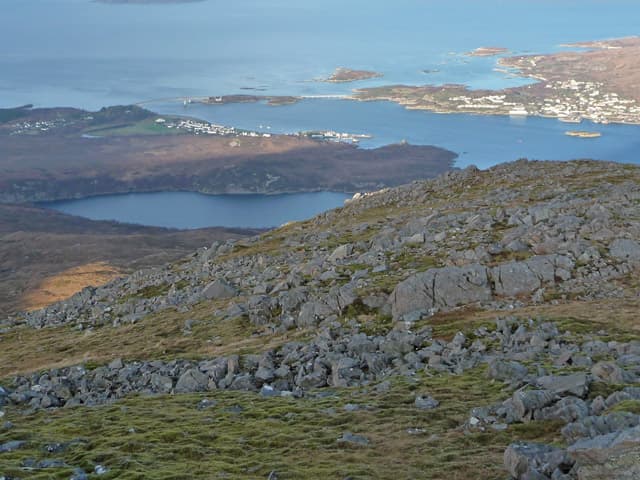
The other half of the Kyle Rhea Graham pair, sitting east of Sgurr na Coinnich above the Glenelg-Kylerhea narrows. A short, sharp grassy cone with a fine outlook over the Sound of Sleat to Knoydart.
Quick facts
- Height
- 731.4m/ 2400ft
- Prominence
- 153 m
- Distance
- 13 km
- Ascent
- 599 m
- Time
- 4–6 hrs
- Grid ref
- NG770229
- Parking
- NG767224
- Nearest
- Fort William· Inverness 92km
- Dogs
- Dogs on lead required near livestockDog-friendly guide ↗
Height and prominence cross-checked against the Database of British and Irish Hills (CC BY).
No GPX track yet
Walked this route? Share your track to help other walkers.
Standard route
island path 25% · heather hillside 45% · rocky upper slopes 20% · summit area 10%
From the Bealach Udal high point on the single-track Kylerhea road, cross the bealach eastwards and follow the broad ridge to the summit. Usually done as a there-and-back from the bealach, or linked with Sgurr na Coinnich opposite.
Terrain
Heather, grass and a few small outcrops. The bealach ground is boggy after rain but the upper slopes drain quickly. No path of any kind.
In winter
Maritime and exposed — wet snow and gale-force westerlies are the norm. The drive to the bealach is the main concern in winter as Kylerhea council road is not a priority for gritting.
Best time of year
Getting there
- Glasgow3h 25m
- Edinburgh4h 2m
OS maps: OS Landranger 33
Mobile signal: Weak at Bealach Udal; signal returns on the descent to Kylerhea
Current conditions
Daylight Today
- Sunrise
- 04:52
- Sunset
- 22:06
- Civil dawn
- 03:52
- Civil dusk
- 23:06
NOAA Solar Calculator · 17 July 2026
Around Beinn na Caillich on the SCOT network
Getting there, basing yourself, and what to do off the hill.
Getting there: Kyle of Lochalsh station
Skye Bridge; Five Sisters of Kintail; Glen Shiel; Plockton
4km from the hill
tripscot.co.uk
On TripSCOTBase yourself in Mallaig
Ferry port for Skye and the Small Isles; CWT finish supply
28km from the hill
tripscot.co.uk
On TasteSCOTAfter the hill: Isle of Raasay Distillery
Raasay — new island distillery with rooms; Dun Caan walks from the door
26km from the hill
tastescot.co.uk
Beinn na Caillich — common questions
- How difficult is Beinn na Caillich?
- Beinn na Caillich carries a 4/5 (challenging) grade on the OutdoorSCOT scale. Count on about 13km, 599m of ascent and a 4-6 hour day on the standard route. Ground conditions: Heather, grass and a few small outcrops.
- How much drop does Beinn na Caillich have?
- The drop is 153m: measured from the summit of Beinn na Caillich down to the saddle joining it to higher terrain.
- Where's the parking for Beinn na Caillich?
- Park at NG767224 near Fort William. Double-check the grid reference on an OS map first; informal laybys here fill early in high season.
- What's the best month to climb Beinn na Caillich?
- Aim for May, June, July, August, September on Beinn na Caillich. In the remaining months treat it as a winter hill — full kit, solid navigation, and a look at the relevant SAIS avalanche forecast before you go.
- Can dogs go up Beinn na Caillich?
- Dogs are fine on a lead. The route passes livestock or ground-nesting bird habitat, so keep them close throughout.
- Will I get phone signal on Beinn na Caillich?
- Weak at Bealach Udal; signal returns on the descent to Kylerhea
- Is Beinn na Caillich safe in winter?
- Maritime and exposed — wet snow and gale-force westerlies are the norm. The drive to the bealach is the main concern in winter as Kylerhea council road is not a priority for gritting.
Get the OutdoorSCOT weekly
One email a week — new route, hill and bothy guides, seasonal conditions and the odd hard-won lesson. No spam, unsubscribe in one click.