Donald · Borders
Pykestone Hill
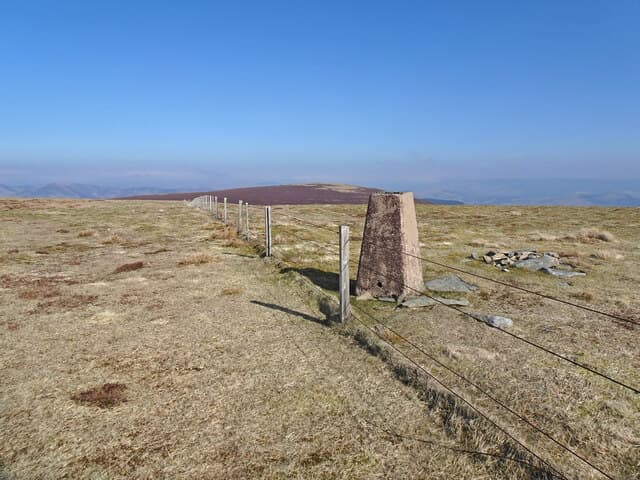
Pykestone is the next summit along the Manor ridge north of Dollar Law, marked by a small cairn beside a weathered concrete trig pillar. Its name probably derives from the pike-shaped boundary stone nearby — a marker for the old shire boundary that still runs along the watershed.
Quick facts
- Height
- 737m/ 2418ft
- Prominence
- 131 m
- Distance
- 14 km
- Ascent
- 604 m
- Time
- 4–6 hrs
- Grid ref
- NT173312
- Parking
- NT168288
- Nearest city
- Edinburgh· 44km
- Dogs
- Dogs on lead required near livestockDog-friendly guide ↗
Height and prominence cross-checked against the Database of British and Irish Hills (CC BY).
No GPX track yet
Walked this route? Share your track to help other walkers.
Standard route
grass moorland 80% · heather patches 15% · summit area 5%
Best joined to Dollar Law and the Manor Hills horseshoe from Glenrath; a slightly shorter line drops into the Stanhope Burn at the col with Drumelzier Law. The cairn is easily walked past on autopilot in mist.
Terrain
Springy mat-grass and the occasional cropped molinia bog along the watershed. The county march fence stays close on the eastern side and is the safest reference in cloud.
In winter
A wind-flayed top that strips the snow into hard sastrugi ridges. Cornicing is rare here as the contours are too gentle. The colder months can offer some of the best walking conditions when frost has set the boggy cols.
Best time of year
Getting there
- Glasgow2h 36m
- Edinburgh1h 2m
OS maps: OS Landranger 72
Mobile signal: Solid summit coverage; EE behaves well. Part of the Manor Hills ridge.
Current conditions
Daylight Today
- Sunrise
- 04:48
- Sunset
- 21:50
- Civil dawn
- 03:52
- Civil dusk
- 22:46
NOAA Solar Calculator · 13 July 2026
Pair with
Curated multi-hill combinations from Pykestone Hill.
On a long-distance route
Pykestone Hill sits within 5km of these named long-distance walks — useful for trail-pack rest days or section extensions.
Around Pykestone Hill on the SCOT network
Getting there, basing yourself, and what to do off the hill.
Pykestone Hill — common questions
- How difficult is Pykestone Hill?
- Pykestone Hill carries a 3/5 (moderately challenging) grade on the OutdoorSCOT scale. Count on about 14km, 604m of ascent and a 4-6 hour day on the standard route. Ground conditions: Springy mat-grass and the occasional cropped molinia bog along the watershed.
- How much drop does Pykestone Hill have?
- The drop is 131m: measured from the summit of Pykestone Hill down to the saddle joining it to higher terrain.
- Where's the parking for Pykestone Hill?
- Park at NT168288. Double-check the grid reference on an OS map first; informal laybys here fill early in high season.
- What's the best month to climb Pykestone Hill?
- Aim for April, May, June, July, August, September, October on Pykestone Hill. In the remaining months treat it as a winter hill — full kit, solid navigation, and a look at the relevant SAIS avalanche forecast before you go.
- Can dogs go up Pykestone Hill?
- Dogs are fine on a lead. The route passes livestock or ground-nesting bird habitat, so keep them close throughout.
- Will I get phone signal on Pykestone Hill?
- Solid summit coverage; EE behaves well. Part of the Manor Hills ridge.
- Is Pykestone Hill safe in winter?
- A wind-flayed top that strips the snow into hard sastrugi ridges. Cornicing is rare here as the contours are too gentle. The colder months can offer some of the best walking conditions when frost has set the boggy cols.
Get the OutdoorSCOT weekly
One email a week — new route, hill and bothy guides, seasonal conditions and the odd hard-won lesson. No spam, unsubscribe in one click.