Donald · Borders
Middle Hill
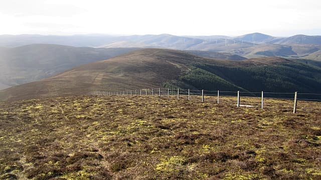
Middle Hill sits — as the name suggests — in the middle of the broad Tweedsmuir watershed between Pykestone and Drumelzier Law. There is no cairn, no fence corner, just an indistinguishable rise on a vast grassy roof. A purely cartographic summit, but a quiet companion on the longer round.
Quick facts
- Height
- 717.2m/ 2353ft
- Prominence
- 42 m
- Distance
- 13 km
- Ascent
- 588 m
- Time
- 3–6 hrs
- Grid ref
- NT159294
- Parking
- NT171308
- Nearest city
- Edinburgh· 46km
- Dogs
- Dogs on lead required near livestockDog-friendly guide ↗
Height and prominence cross-checked against the Database of British and Irish Hills (CC BY).
No GPX track yet
Walked this route? Share your track to help other walkers.
Standard route
grass moorland 85% · heather patches 10% · summit area 5%
Tagged on a Manor Hills ridge walk from Glenrath or from Drumelzier in the Tweed. Best reached by walking through from Pykestone Hill since the navigation from below is almost impossible to pinpoint without GPS.
Terrain
A bowling green of dry moorland turf — fast going in any direction with no obstacles bar the occasional peat hag. The watershed fence is the only landmark for a kilometre in every direction.
In winter
A whiteout death-trap in cloud and snow. The plateau is so flat that even GPS can take time to settle on the high point. Bearings off the watershed fence are the safest method; do not push on if you lose sight of it.
Best time of year
Getting there
- Glasgow2h 36m
- Edinburgh1h 5m
OS maps: OS Landranger 72
Mobile signal: Decent up top; count on EE. Smooth Tweedsmuir Hills plateau.
Current conditions
Daylight Today
- Sunrise
- 04:48
- Sunset
- 21:50
- Civil dawn
- 03:53
- Civil dusk
- 22:45
NOAA Solar Calculator · 13 July 2026
On a long-distance route
Middle Hill sits within 5km of these named long-distance walks — useful for trail-pack rest days or section extensions.
Around Middle Hill on the SCOT network
Getting there, basing yourself, and what to do off the hill.
Middle Hill — common questions
- Is Middle Hill a hard climb?
- Middle Hill is rated 3/5 (moderately challenging) on the OutdoorSCOT scale. The standard route covers about 13km with 588m of ascent and takes most walkers 3-6 hours. Ground conditions: A bowling green of dry moorland turf — fast going in any direction with no obstacles bar the occasional peat hag.
- How much drop does Middle Hill have?
- The drop is 42m: measured from the summit of Middle Hill down to the saddle joining it to higher terrain.
- Where's the parking for Middle Hill?
- Park at NT171308. Double-check the grid reference on an OS map first; informal laybys here fill early in high season.
- What's the best month to climb Middle Hill?
- Aim for April, May, June, July, August, September, October on Middle Hill. In the remaining months treat it as a winter hill — full kit, solid navigation, and a look at the relevant SAIS avalanche forecast before you go.
- Can dogs go up Middle Hill?
- Dogs are fine on a lead. The route passes livestock or ground-nesting bird habitat, so keep them close throughout.
- Will I get phone signal on Middle Hill?
- Decent up top; count on EE. Smooth Tweedsmuir Hills plateau.
- Is Middle Hill safe in winter?
- A whiteout death-trap in cloud and snow. The plateau is so flat that even GPS can take time to settle on the high point. Bearings off the watershed fence are the safest method; do not push on if you lose sight of it.
Get the OutdoorSCOT weekly
One email a week — new route, hill and bothy guides, seasonal conditions and the odd hard-won lesson. No spam, unsubscribe in one click.